There's a brand-new map of Denver's old streetcar lines.
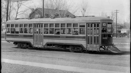
University of Denver graduate student in the Department of Geography and the Environment, Ryan Keeney, created an interactive map for his master's capstone project - showing the history of streetcars in the city.
He spent months going through historic maps then used mapping software to create every street car line that existed between 1872 and 1950.
"What really surprised me was the extent of the street car system. How densely it covered the central part of the city, and how dynamic it was, and how frequently it changed over time," Keeney said.
Keeney's online map provides aerial views from current time and back in 1933. It also includes a slider that allows viewers to take a look at streetcar tracks for certain years.
You can also play the map at different speeds to see how the lines changed over the years, and were eventually phased out by cars.
"The automobile came on scene and became more competitive than the street car," Keeney said. "Denver just became a more car-oriented city and the train way company wasn't able to compete with that in the long-term. By 1950 all the lines were torn out, but these commercial districts most of them remained intact and are still here to this day."
Some of those commercial districts include Colfax, Broadway and South Pearl. Keeney hopes the city will use his research.
"I hope it influences city policy to make Denver a better place for the future that's less car-dependent and more transit, and walk, and bike-friendly that would be an amazing long-term impact," he said.
Keeney hopes more transit options will lead to more commercial development like it did back then.
"Most people used transit to get around the city," Keeney said. "When they were going home they would disembark from the street cars at the stop closest to their homes, and at these stops, commercial districts would form. People who were getting off the streetcars would patronize the businesses to get their groceries, before walking home that's how they kind of developed in tandem."