

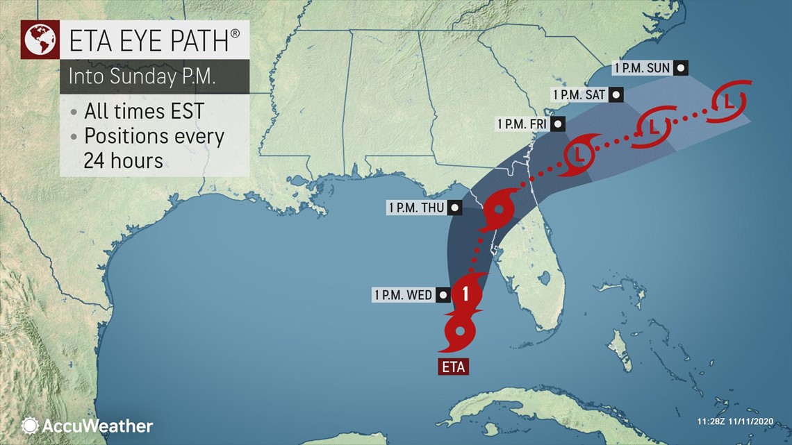
Eta restrengthened into a hurricane Wednesday in the Gulf of Mexico, less than 200 miles south of Tampa, with maximum sustained winds of 75 mph. The Category 1 storm had been growing stronger throughout the overnight hours and forecasters now expect it to make a second landfall in the state only days after striking the Florida Keys.
Hurricane watches, tropical storm warnings and storm surge watches were in effect for parts of Florida's west coast as the storm strengthened. It was moving to the north-northeast at a speed of 15 mph, the National Hurricane Center said, and tropical-storm-force winds extend outward up to 115 miles (185 km) from the center of Eta.

Eta stalled just off the western tip of Cuba on Tuesday, where it continued to pose flooding threats to South Florida and Cuba. Eta moved southwestward over the Gulf after striking the Florida Keys late Sunday, when it became the first named storm to make landfall in Florida this hurricane season.
As a strong tropical storm, Eta unloaded torrential rain -- up to nearly 18 inches -- in South Florida Sunday into Monday, causing widespread flooding of streets and low-lying areas in the Miami and Fort Lauderdale, Florida, areas.

For Cuba, this was the second round of torrential rain from Eta, which cut through the central part of the island during Saturday night and early Sunday.
Eta is more than a week removed from its calamitous impacts in Central America where it produced devastating flooding and mudslides, killing over 50 people in Guatemala alone. Eta was most recently a hurricane on Nov. 4, when it moved inland over Nicaragua.
Satellite images on Tuesday showed potent thunderstorms erupting near the center of the storm. Because of that, forecasters said the storm appeared to be overcoming dry air in the region, which they said points to further strengthening of the system being likely.
Eta had weakened to a 50-mph tropical storm late Monday and remained in status quo as it drifted southwestward over the Gulf of Mexico during Monday night as dry air had encircled the storm and invaded its core. However, maximum sustained winds had increased to 60 mph early Tuesday, and additional strengthening is likely into Wednesday. Eta was nearly stationary at midday Tuesday, but then accelerated northward later Tuesday night.
"Eta should remain over very warm water and within an environment of low wind shear, both of which favor strengthening [through the middle of the week]," according to AccuWeather's top hurricane expert Dan Kottlowski.
"If the core circulation remains intact and if Eta can manage to divorce itself from the dry air on its periphery, it should continue to intensify," Kottlowski explained.
Due to weak steering breezes, Eta will be a slow mover as it continues to churn over Gulf waters.
The stronger Eta becomes and the longer it remains a strong tropical storm or even a hurricane, the more likely its forward motion will be controlled by southwesterly upper-level winds, which could take it closer to the west coast of Florida. In this case, the storm would be taller and extend higher into the atmosphere, compared to a weak or shallow system.
"The projected complex wind pattern over the storm suggests that an increase in shear will cause the storm to weaken and become more shallow in nature over the northern Gulf of Mexico, and thus be more under the influence of the lower-level winds around the western periphery of the Bermuda Azores high pressure area," Kottlowski explained.
Based on the anticipated weakening of Eta, AccuWeather's current forecast has the system moving northward toward the northwestern Florida Peninsula and is expected to make landfall on Thursday as a weakening tropical storm or eventual tropical depression over land in northern Florida.
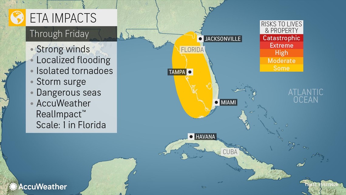
AccuWeather meteorologists predict that the biggest threat Eta will pose to the U.S. as it makes a second landfall will be from heavy rainfall and potential flooding. Eta may soak areas that will first pick up rainfall from a non-tropical storm system that will tap into tropical moisture. That weather maker will unload drenching rain from northern Florida to southern Maine on Wednesday into Thursday and could leave the ground saturated in this corridor.

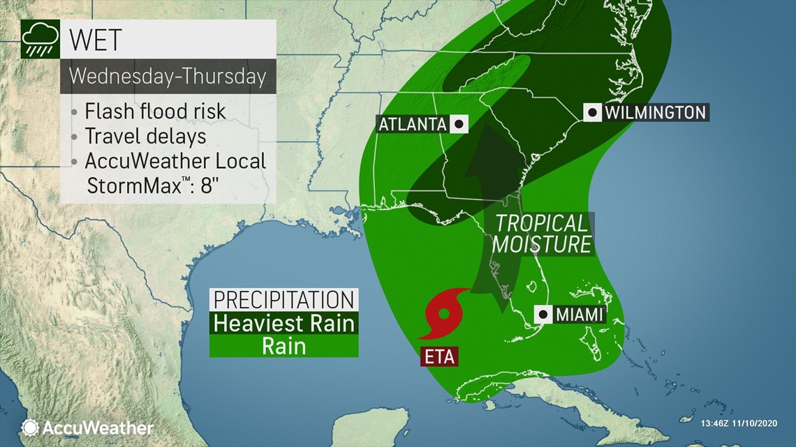
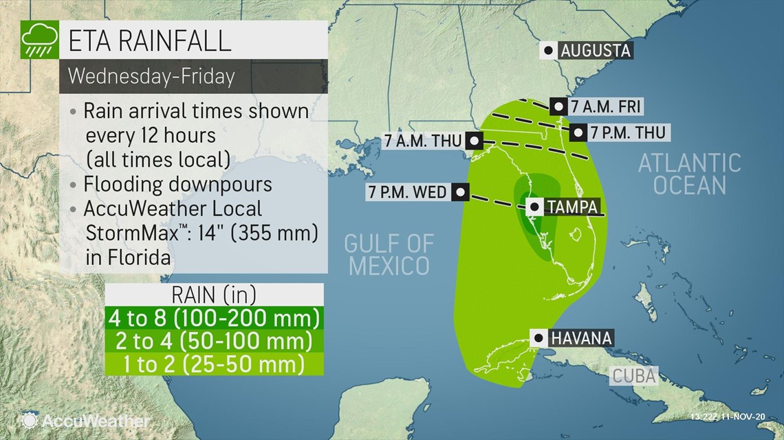
Rain directly associated with Eta is forecast to spread northward by this weekend into parts of the Florida Panhandle, Georgia and perhaps part of Alabama. However, rainfall amounts in these areas of the U.S. will be highly dependent on Eta's strength. With an expected landfall, rainfall amounts could range from 4-8 inches with an AccuWeather Local StormMax™ of 14 inches.
"If Eta becomes a weak storm, a depression or falls apart, it won't have the ability to produce any significant rainfall," Kottlowski explained. "However, if Eta were to maintain a strong circulation, it could bring a few inches and possible flooding to parts of the southeastern U.S."

Eta could interact with a cold front that is forecast to dip into the region at the end of the week, potentially enhancing rainfall, according to Kottlowski.
The system's strength will also determine the extent and intensity of winds and storm surge as the system nears the coastline and pushes ashore.

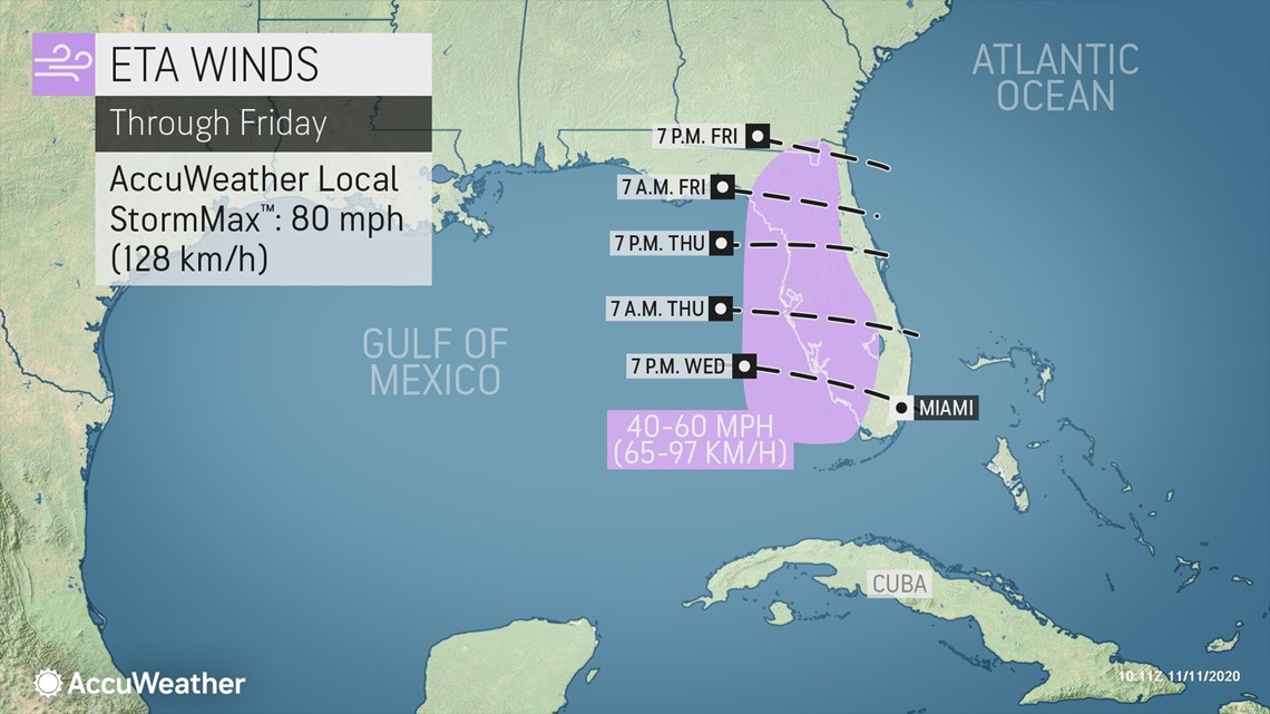
Forecasters are urging residents in the U.S. who live along Florida's west coast to southeastern Louisiana to monitor the progress of Eta due to the potential for flooding rain, strong winds and storm surge late this week and into this weekend.
Record-tying Eta, the 28th named storm of the season, is no longer alone in the basin. Subtropical Storm Theta formed over the central Atlantic late Monday evening, setting a new record for the Atlantic. Theta became the 29th named storm of the 2020 Atlantic hurricane season, beating out 2005 for the most storms to ever develop in a single season. And the two storms together -- Eta and Theta -- became the latest storm duo to churn in the Atlantic since Nov. 10, 1932, according to Philip Klotzbach, a Colorado State meteorologist.
The Atlantic may not stop with Theta as AccuWeather meteorologists are monitoring the Caribbean for more tropical activity late this week and this weekend. Should an area of disturbed weather entering the Caribbean reach tropical storm status and become the 30th such storm of 2020, it would be named Iota.
AccuWeather meteorologists believe the tropical Atlantic may remain active through the official end of hurricane season, which is Nov. 30, and there is even the possibility of tropical activity in the basin during December.