DENVER, Colorado — The average date for Denver to get its first snow of the fall is Oct. 18.
We beat that date the last couple of years. It came on Oct. 6 in 2018 — 1/2 inch at DIA. Most areas in the metro saw little more than some slush. The first decent accumulation came on Oct. 14.
In 2017, it came Oct. 9. That time it was a nice 2.8 inches. We had to wait until November in 2016, 2015 and 2014.
There is rarely any real impact with the first few snows, but it is fun to keep an eye on. The first snow can be highly anticipated, while each storm after than loses it's luster — unless it is forecast to be big.
And by the way, "big" for Denver nowadays is anything more than 6 inches. Most storms here are much less than that.
We do have a few storm systems forecast to swipe Colorado in the next 10 days, so lets keep an eye on 'em. I will post an update every day after the 12z model runs, until the first measurable snow comes to DIA.
Tuesday Update
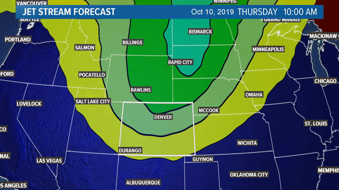
Mid-Week Storm (Oct. 9-11)
Still little has changed with the approaching storm system. Computer models remain consistent and in unison for the most part. That first snow of the season is very likely for most of us on the Front Range, including DIA.
A fast moving and powerful cold front will be felt cruising thourgh the Denver area by about 6 or 7 pm on Wednesday. Its arrival will likely be very noticeable. The abrupt temperature drop will be from the upper 70's at 4pm, to middle 40's by 9pm.
By about 10pm Wednesday night, the precip should start falling around the Front Range. Could be a rain snow sleet mix until about midnight. Then switching to snow. Shouldn't be too heavy in the overnight hours. Could even stop in some places. City streets will likely just be wet during the morning commute on Thursday but likely still slow due to some falling snow at the time.
The heaviest snowfall will probably come in a surge of about 6 hours. The NAM shows this wave of snow from about 8am to 2pm in the metro. Resulting in accumulation of about a half inch to 3 inches in areas. The projected accumulation at DIA from the NAM is .7". The Euro 1.5, and GFS 2.5.
Temperatures then continue to drop in to Friday morning. Both the GFS and the Euro show temps bottoming out in the upper teens. The NAM is still not in range of Friday morning.
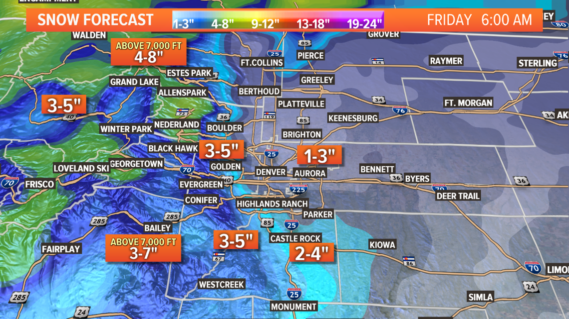
The chance of that first snow accumulation has gone up, but the total has gone down a bit. Mainly due to the NAM's influence. It handled last winters events well, but is know for being a little on the dry side.
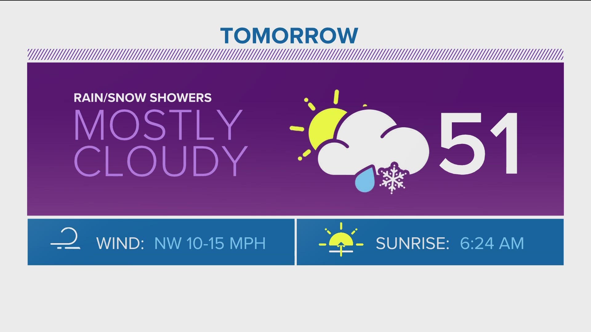
Chance of snow at DIA = 75% (estimated total: 1.5 inches)
October 20 Storm
The modeling is still hinting of another storm impacting Colorado around October 20, but the solutions are still not consistent enough for any mention.
Just a little more than two days now until the storm's arrival, and the computer models have still not wavered. There's a high chance of the first snow accumulation in Denver on Thursday morning.
The cold front is now in range on the NAM up to midnight Wednesday. It shows the front crashing into the Denver metro at 6 p.m. shortly after hitting a daytime high temperature of 77 degrees. It shows the temp getting down to 32 degrees at DIA right at midnight.
With the precipitation starting at about 9 p.m., initially as a mix of rain, sleet and snow. Snow accumulation before midnight seems possible, but unlikely.
The GFS has not changed much. It shows the cold front arriving at 7 p.m., with the temperature still 39 degrees at midnight. It has sub-freezing temps starting between 2 a.m. and 3 a.m. on Thursday morning, then reaching a low of 22 that night, and never reaching back above 30 for the day, then into the teens on Friday morning.
It shows it snowing from 4 a.m. to 4 p.m. with a total accumulation of 2.2 inches at DIA.
The Euro also shows the cold front arriving in Denver at 7 p.m., with a midnight temp of 35 degrees. It has a low of 22 Thursday night, then drops a bit more to 19 on Friday morning.
The precipitation starts out between 9 p.m. and midnight, also showing the possibility of a mix at first. It shows snow from midnight to 9 p.m., with a total accumulation at DIA of 1.9 inches.
Chance of Snow at DIA = 60% (estimated total: 2.0 inches)
Still nothing consistent beyond Oct 11
Monday Update
Mid-Week Storm (Oct. 9-11)
Just a little more than two days now until the storm's arrival, and the computer models have still not wavered. There's a high chance of the first snow accumulation in Denver on Thursday morning.
The cold front is now in range on the NAM up to midnight Wednesday. It shows the front crashing into the Denver metro at 6 p.m. shortly after hitting a daytime high temperature of 77 degrees. It shows the temp getting down to 32 degrees at DIA right at midnight.
With the precipitation starting at about 9 p.m., initially as a mix of rain, sleet and snow. Snow accumulation before midnight seems possible, but unlikely.
The GFS has not changed much. It shows the cold front arriving at 7 p.m., with the temperature still 39 degrees at midnight. It has sub-freezing temps starting between 2 a.m. and 3 a.m. on Thursday morning, then reaching a low of 22 that night, and never reaching back above 30 for the day, then into the teens on Friday morning.
It shows it snowing from 4 a.m. to 4 p.m. with a total accumulation of 2.2 inches at DIA.
The Euro also shows the cold front arriving in Denver at 7 p.m., with a midnight temp of 35 degrees. It has a low of 22 Thursday night, then drops a bit more to 19 on Friday morning.
The precipitation starts out between 9 p.m. and midnight, also showing the possibility of a mix at first. It shows snow from midnight to 9 p.m., with a total accumulation at DIA of 1.9 inches.
Chance of Snow at DIA = 60% (estimated total: 2.0 inches)
Still nothing consistent beyond Oct 11
Sunday Update
Mid-Week Storm (Oct. 9-11)
This morning's model runs show more consistency, other than a little slow down in the movement of the system. This raises confidence even higher of Denver's first snow accumulation of the season happening this Thursday.
The GFS still shows a powerful cold front with a little longer duration. Accumulation at DIA would be 2.9 inches with this current solution. The timing of the bulk of the storm would be from 6 a.m. to 6 p.m. Thursday, which is a little later than previous runs.
This storm could be a little shocking to the system, with near 80-degree temps on Wednesday afternoon dropping into the 20s by Thursday morning. The snow could be heavy at times as well, even though accumulation isn't forecast to be too impressive, mostly less than 3 inches. The 27-degrees temperatures with snow and ice on Thursday morning is sure to slow down the commute.
The Euro remains consistent with snow and cold, 1-3 inches of accumulation. DIA would get 1.5 inches with the current solution, which would be plenty more than the 1/10 inch necessary to qualify for the first snow of the season.
This model is a little more consistent with its timing, showing the bulk of the storm from midnight to 9 p.m. Thursday.
The mesoscale models will start picking up on the storm tomorrow. That will increase the amount of information with this forecast.
Chance of snow at DIA = 45%
Mid-Week Storm (Oct. 16)
Models have been on and off showing a storm system around Oct 16. When it's there, it shows some snow for the mountains. No consistency there yet though.
Saturday Update
As expected, Saturday's front had little impact. Another front moves through on Sunday morning. That should be a little colder and may deliver some light snow to the high mountain peaks, but there will not be much precipitation with it, especially down low.
Chance of snow at DIA = 0%
Mid-Week Storm (Oct. 9-11)
Not much has changed over the last 24 hours of computer modeling. That will boost the confidence of metro impacts just a bit.
The GFS has held steady with its solution of a fast-moving and powerful cold front moving through the metro late Wednesday night (around midnight). It drops temperatures down into the 20s before sunrise and brings snow to Denver between midnight and 4 a.m. on Thursday morning, with accumulation just under 1 inch.
The Euro has brought back its cold and snowy solution over the past two runs. It also shows the front coming in late Wednesday night, and drops temps into the 20s, but it has a longer-lasting snow event with snow totals in the 1-3 inches range.
It's just five days away from this cold front now, and the computer modeling is holding with good consistency. That increases the confidence in this being a powerful cold event with temperatures dropping below freezing in Denver.
It also increases the confidence in timing with both models having an arrival of late Wednesday night. The cold air should stick around until Friday afternoon.
I would say it boosts confidence in measurable snow occurring at DIA as well. Snow accumulation is not really too reliable this far out though. Because we are still five days away, I won't raise the probability too high, but due to the consistency we are seeing, the chances will go up.
Chance of snow at DIA = 30%
Friday Update
This Weekend (Oct. 5-6)


A trough in the jet stream will just scrape by to the north of the state this weekend, but it will only bring some breezy and slightly cooler air to the state, likely only resulting in a bit of a dusting on the high mountain peaks.
Chance of snow at DIA = 0%
Mid-Week next week (Oct. 9-11)
A better opportunity comes mid-week next week. There are certainly things to like about the current forecast with this system if you like cold and snow, but in general there is not a high chance of there being snow in the Denver area.
The likable part for snow lovers is that there has been some consistency in the computer modeling inside of day 7 now. All of Thursdays GFS runs showed the storm moving right into northeast Colorado and also showed snow accumulation possible in Denver.
The 00z run of the Euro even joined in on the fun.
However the 12z Euro has dropped its cold and snowy solution a bit, while the 12z GFS has dropped it altogether.
The problem with this system is that it might end up being a broken off piece of the main jet stream flow, which is forecast to stay well to the north, even as far north as Canada. When the energy gets cut-off, it becomes much more unpredictable.
The chances of our northern mountains getting their first respectable snow of the season are increasing, but not certain yet.
The chances of the metro areas getting the coldest air of the season so far is increasing. It could even drop below freezing for a few hours — not a blow-your-sprinklers-out kind of cold yet, but certainly a good chance for the first freeze in Denver.
Some consistency in the models is there, however they're trending down at the moment. Add in the fact it could be a cut-off low, add in the fact that the modeling has shown systems in the 7-10 day period that have not verified, and you get the current odds.
Chance of snow in Denver = 15% (can't go a full 20 here yet).
SUGGESTED VIDEOS | Science is cool