

Less than one week after record-setting Hanna strengthened into a hurricane and crashed into the Texas coast, another budding tropical system was dubbed Potential Tropical Cyclone Nine by the National Hurricane Center (NHC) at 11 a.m. EDT Tuesday and maintained that status through Wednesday afternoon. On Wednesday evening, this system developed a single well-defined center and was upgraded to Tropical Storm Isaias (pronounced ees-ah-ee-ahs).
This makes it the earliest "I-storm" on record in the Tropical Atlantic, breaking the record previously held by Irene, which formed on Aug. 7, 2005.
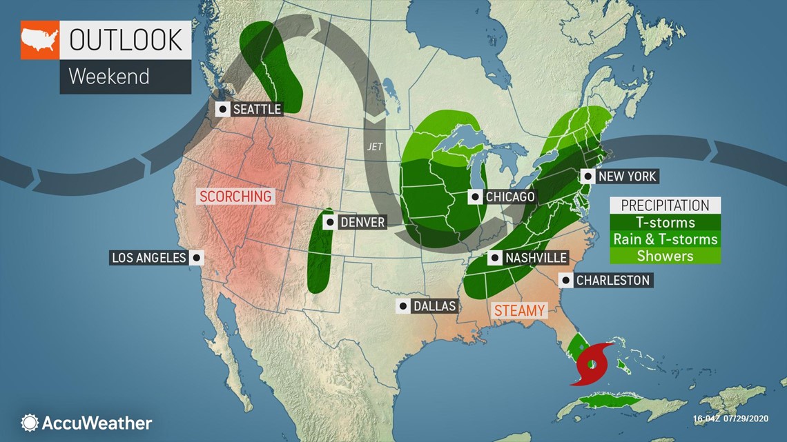
This tropical storm threatens another potential impact to the United States.
The system is forecast to blast the islands of the northern Caribbean with heavy rain, gusty winds and building seas this week, prior to aiming toward the southeastern U.S. later this weekend to early next week.

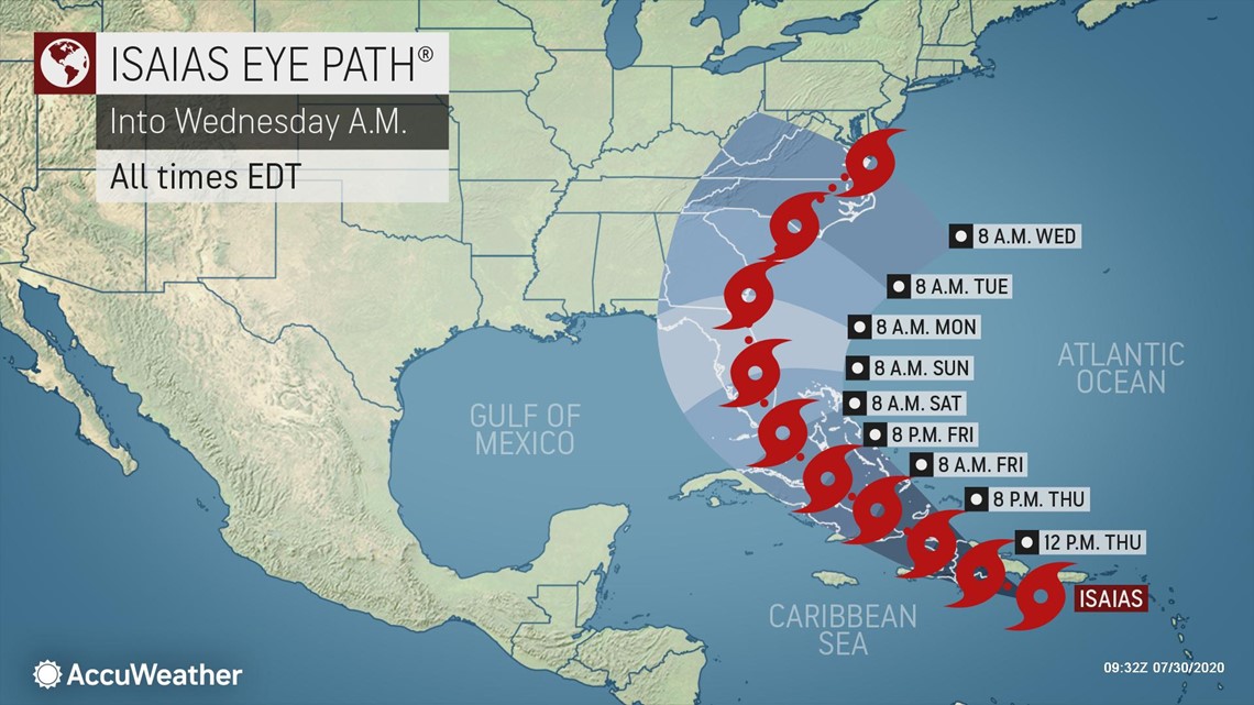
Isaias was churning south of Puerto Rico with maximum sustained winds of 60 mph early Thursday morning and was racing west-northwestward at 21 mph. The tropical storm was less than 150 miles away from Santo Domingo, Dominican Republic. The center is forecast to cross the island of Hispaniola (which consists of the countries of Haiti and the Dominican Republic) on Thursday.
Tropical storm warnings were in effect for Puerto Rico and the U.S. Virgin Islands, as well as all of the Leeward Islands and portions of the Dominican Republic and Haiti on Wednesday. The government of the Bahamas issued a tropical storm warning for the Turks and Caicos Islands and the southeastern Bahamas and a tropical storm watch for the central Bahamas.
On Wednesday evening, the tropical storm watch for the central Bahamas was upgraded to a tropical storm warning and a tropical storm watch was issued for the northwestern Bahamas.
By Thursday morning, the tropical storm warnings for the Leeward Islands were discontinued as Isaias moved westward away from that area.
Impacts from localized torrential rain and tropical-storm-force winds extend outward from the system's center up to 415 miles, mainly on the northern and eastern side, so people in the northern Caribbean are urged to stay aware of dangers, including rough seas, even well away from the center and eye track. Conditions can deteriorate 12 to 24 hours ahead of the fast-moving system, which is traveling at about twice the average speed of tropical systems in this part of the Atlantic.
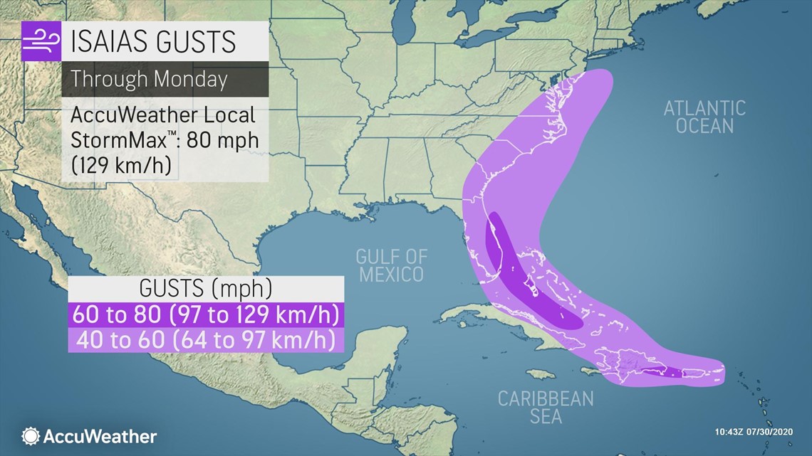
The Luis Munoz Marin International Airport in San Juan recorded a wind gust of 44 mph on Wednesday, the NHC reported. St. Thomas in the U.S. Virgin Islands also had a wind gust to 52 mph early Wednesday afternoon. A wind gust of 51 mph was observed earlier Wednesday in St. Maarten.
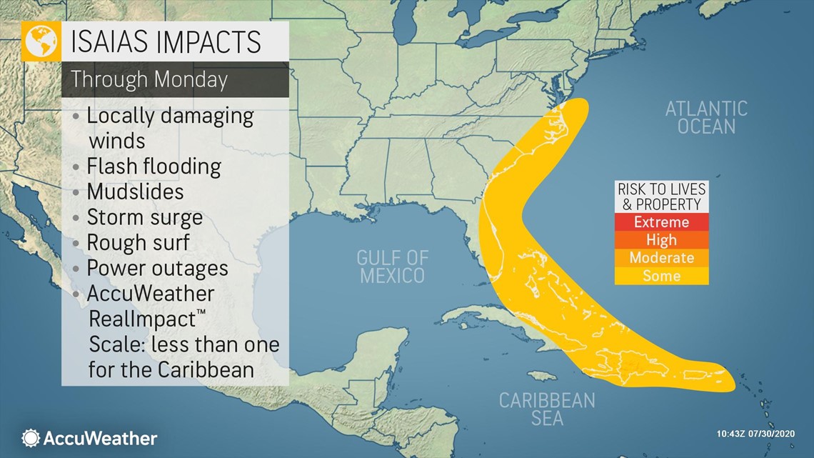
Isaias is forecast to be less-than-one on the AccuWeather RealImpact™ Scale for Hurricanes across the northern Caribbean into Friday.

Unlike Gonzalo, which was a very compact storm that developed in a similar area, the tropical-storm-force winds associated with this system are sprawled out over an area of approximately 830 miles. In comparison, Gonzalo's tropical-storm-force winds extended across a distance of only 50 miles.
"The most substantial impacts moved through the Windward Islands Wednesday before passing through Puerto Rico Wednesday night and will arrive in Hispaniola on Thursday," AccuWeather Senior Meteorologist Rob Miller said.
Winds on some of the islands will get strong enough to cause property damage, knock over trees and lead to power outages, including on Puerto Rico, the U.S. Virgin Islands, the Dominican Republic, Haiti, the Turks and Caicos, part of the northern coast of Cuba and the southern Bahamas into Friday.
"Some intensification is expected prior to the storm crossing Hispaniola Thursday with damaging wind gusts of 60-70 mph with an AccuWeather Local StormMax™ of 80 mph possible over Hispaniola," Miller stated.

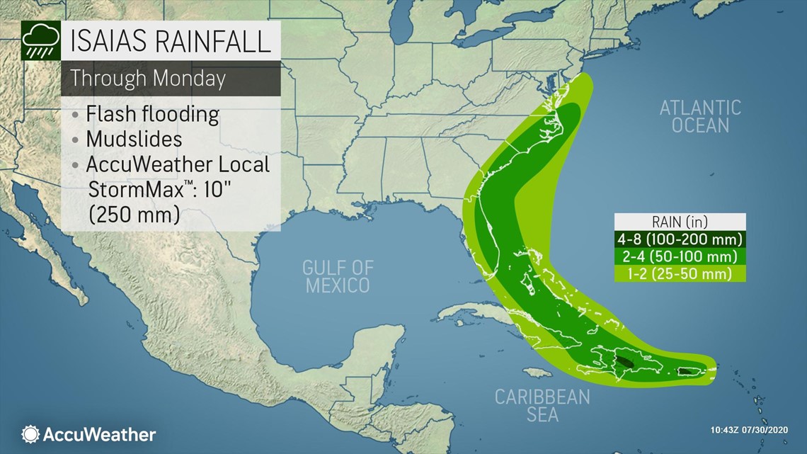
Even though the storm will bring needed rain to the islands, too much rain will fall too quickly in a number of instances, leading to flash flooding and mudslides.
"Rainfall amounts of 2-4 inches can be expected with 4-8 inches and an AccuWeather Local StormMax™ of 10 inches possible over any higher terrain," Miller added.

The name Isaias was added to the Atlantic list after Ike caused destruction in Texas in 2008 and was retired in 2009. It has not yet been used. Should the tropical storm form prior to Aug. 7, it would set another early-formation record for the season. Irene from 2005 currently holds the title for the earliest ever "I-storm" in the basin.
Interaction with the islands in the northern Caribbean, especially the mountainous terrain of the larger islands, is expected to exert a drag on the feature and should take the edge off the overall strength. Such a close track over the islands of the northern Caribbean would also raise the risk to lives and property from flooding rain, mudslides and strong winds.
The high mountains on Hispaniola, and to some extent Puerto Rico and Cuba, act as a natural barrier to the path of the storm. Tropical systems generally avoid tracking over the heart of these islands as a result, but there have been some exceptions. The mountains tend to cause the center of an approaching tropical storm or hurricane to jump from one coast to the other and re-form in the process.
The overall strength of the system may also determine its fate as far as a track is concerned. Early on, a well-organized, stronger system is more likely to curve northwestward and northward faster than one which remains poorly organized and stays weak. Since the more northern disturbance associated with the system developed during Wednesday night, the forecast track has shifted farther north accordingly. There were at least two weak circulation centers competing on Wednesday.
Will the system strike the US?
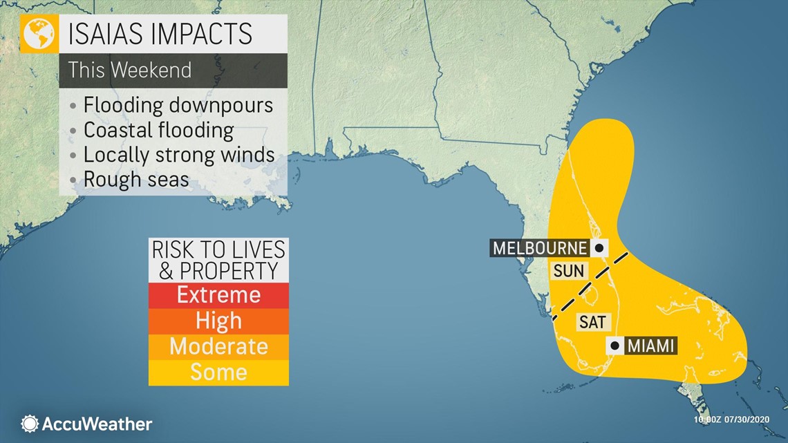
Landfall in Florida is not absolute at this point. There is still room for the storm to turn east of Florida and the Carolinas, or even travel farther west over the Gulf of Mexico.
Florida is one of the states that has been experiencing a tremendous surge in coronavirus cases over the last month. On Tuesday, the state recorded 191 COVID-19-related fatalities, the most there since the outbreak began, according to Reuters.
With the potential for a strike by a tropical storm looming, health officials in Collier County, which encompasses Naples on the state's Gulf Coast, announced Tuesday that two testing clinics would be shut down ahead of any storm that may arrive. A walk-up testing site in Immokalee will close down on Thursday and one in Naples will be shuttered on Friday, officials said on Twitter. Late on Wednesday afternoon, it was announced that state-run testing sites would be closing on Thursday and remain closed through Sunday across the entire state. Meanwhile, Florida Gov. Ron DeSantis on Wednesday urged Floridians to "prepare now by having at least 7 days of disaster supplies" on hand.
"At this juncture, the realm of possibilities of potential tracks for this system still range from the Gulf of Mexico to waters east of the United States and Canada and includes all areas in between," Miller said on Wednesday.

How Isaias survives the big island Hispaniola may determine its future strength farther to the north this weekend to early next week.
AccuWeather Chief Broadcast Meteorologist Bernie Rayno said that whether or not Florida experiences major impacts depends on if the storm moves over Hispaniola, where he said it could fall apart. If it stays north of the island and maintains a circulation over water, however, "There could be some re-development or certainly moisture approaching Florida, or even [elsewhere on] the southeast coast of the United States," he said.
The amount of wind shear near North America, which is never in a steady state, could also play a role in the system's strength upon its approach. Strong wind shear, or the changing of winds with altitude, can limit tropical development and even tear apart organized systems, causing them to weaken.
The non-tropical system over the U.S., associated with a dip in the jet stream, may also help to steer the system to the north and northeast once it nears the U.S.
The overall large size of the storm is likely to at the very least spread some downpours, gusty thunderstorms and rough surf conditions around the Florida Peninsula and perhaps the Keys and northwestern Bahamas this weekend. The overall coverage and intensity of these conditions will depend on the storm's track as well as its ability to rebound after it crosses the Greater Antilles.

Waters in the northern Caribbean Sea, western Atlantic Ocean and the Gulf of Mexico are sufficiently warm enough to not only sustain a tropical system but also potentially add to its strength.
"Assuming the storm survives an encounter with Hispaniola or Cuba, some renewed strengthening of wind intensity is expected north of the islands," Miller said.
Exactly how much, if any, strengthening occurs north of the large Caribbean islands is unclear at this point.
"Water temperatures are near 90 F in the Gulf Stream east and south of Florida," according to AccuWeather Senior Meteorologist Paul Walker.
Walker added that he has seen a great many systems intensify over the Gulf Stream in his more than four decades of studying the tropics and weather conditions over the Southern states.
There is a chance Isaias becomes a hurricane after it pulls away from Hispaniola and Cuba late this week and this weekend.
All interests from the northern Caribbean to the Bahamas, Bermuda, the U.S. and northeastern Mexico are urged to monitor the progress of this feature, which is destined to become the next named tropical system and perhaps the next hurricane in the Atlantic for 2020.
AccuWeather's top hurricane expert Dan Kottlowski, assisted by Lead Long-Range Meteorologist Paul Pastelok and other team members, has been studying the anticipated weather conditions for the months ahead and will be issuing an update to the numbers of tropical storms, hurricanes, major hurricanes and direct impacts to the United States for the Atlantic season this week.
Thus far, the 2020 season has outpaced the formation speed of the 2005 season, but not so much in terms of the number of hurricanes. Hanna became the first hurricane of the Atlantic season early on July 25 and also became the first hurricane to strike the U.S. later that day. By the time Hanna became a hurricane, the 2005 season had already spawned three hurricanes: Cindy, Dennis and Emily.
Both Dennis and Emily became major hurricanes with peak winds of 150 and 160 mph respectively. Hurricane Irene, packing peak maximum sustained winds of 105 mph, would follow in August of 2005. Irene was classified as a Category 2 hurricane at its strongest.

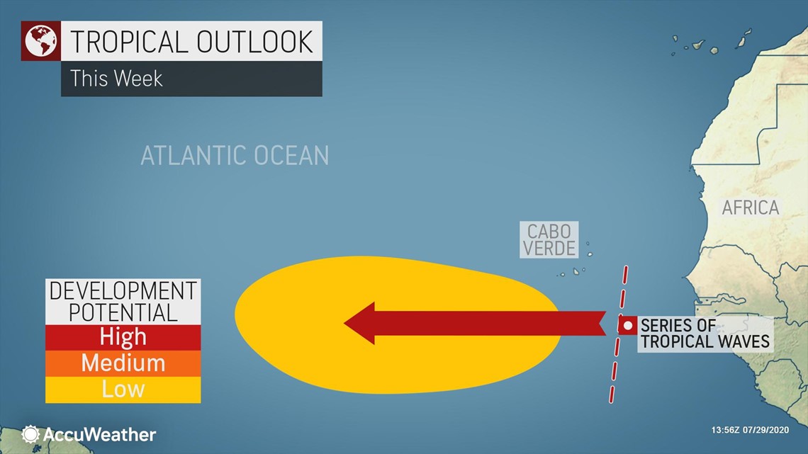
With a couple of weeks to go until the peak of hurricane season begins in the middle of August, disturbances are lining up over Africa and moving westward with each feature every one to three days apart. This series of disturbances is known as the Cabo Verde part of the hurricane season, and it is just beginning to ramp up.

Most likely, more early-season formation records will be set in the coming weeks with 2005's holdings being swapped with 2020's newcomers. The "J-storm" record is currently held by Jose on Aug. 22, 2005, with the "K-storm" record held by the infamous Katrina, which formed on Aug. 24, 2005.