COLORADO, USA — This blog watches winter storms develop in computer forecast modeling. It will be updated once a day until the next storm hits the Denver metro area.
Dec. 1 is the first day of winter -- meteorologically speaking anyway. The winter forecasts that came out at the end of summer, where for the time period of Dec.1 - Feb. 29.
The NOAA forecast called for a warmer winter, which means warmer than the average temperature. For example, in Denver that is 31.1 degrees in December, so a freezing average would be a warm December.
The NOAA forecast for precipitation said there was just as good a chance for getting more snow in Colorado as getting less snow.
The Farmers Almanac called for a cold and snowy Polar Coaster of a winter. The fall weather pattern would certainly be classified as erratic, we'll see if it keeps up.
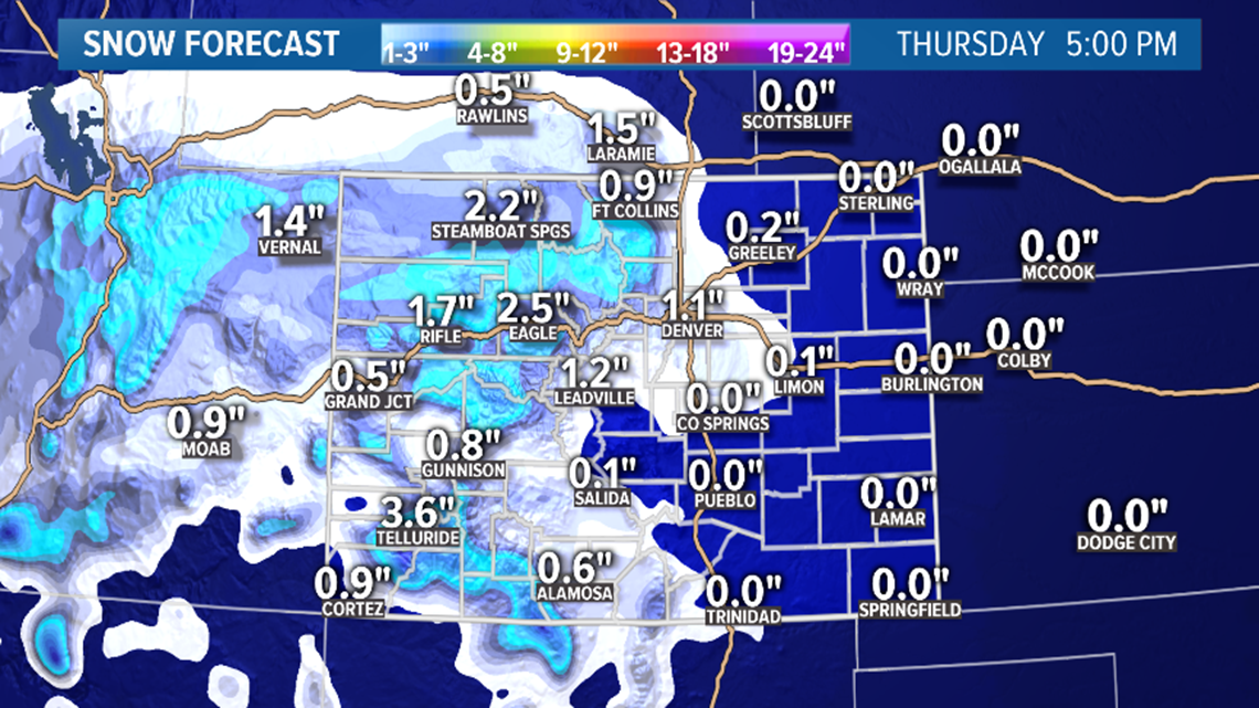
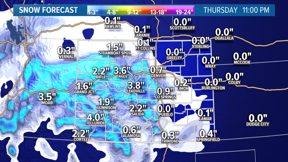
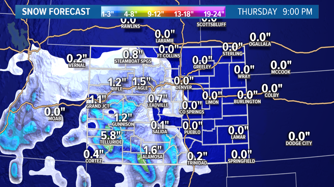
Wednesday Update:
Dec. 5
Storm system is finally moving through California and into Nevada. It will be a fast mover, so radar should start to light up in the mountains soon.
This will still mostly impact the San Juans, but with just about all southern storm tracks, there will also be a brief bout of upslope winds on the Front Range. That will start Thursday morning.

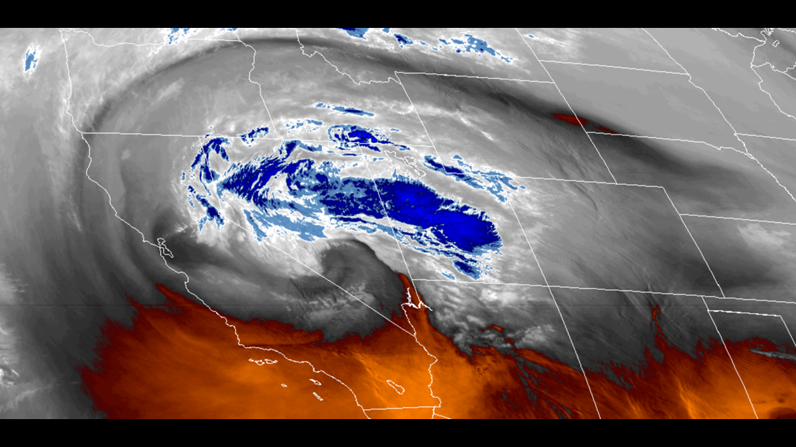
For the San Juans, there is a Winter Weather Advisory out for 6-12 inches of snow by Thursday night. Southwest Colorado could get a pretty wild wave of weather initially around midnight, with thunder, lightning, hail, and then thundersnow.
The snow should reach Vail Pass and Summit County by about 2am. Only 1-3" expected there.
This will be a pretty sloppy storm on the Front Range. The upslope should kick in by about 6 or 7am. Most likely there will be a wave of rain, maybe even heavy rain. I know it seems our storms still go directly to snow, but the chances are much higher for it to start as rain.
If by chance it goes straight to snow, I still would not expect accumulation on the roads with temps right at 32 or 33 degrees, but visibility could be an issue during the commute.

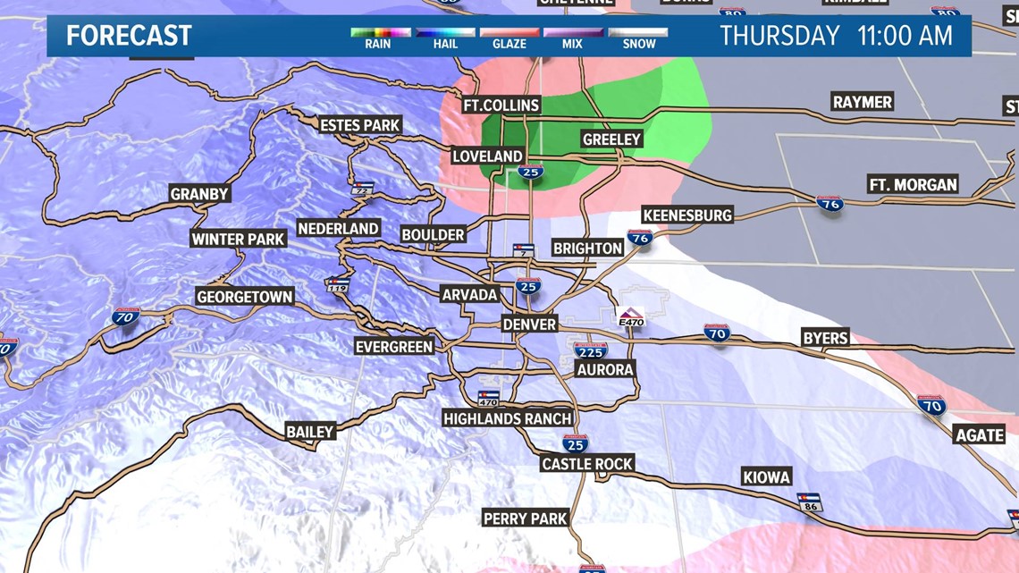
That also means the ground will be too warm for rain or drizzle to freeze on contact, so not much of a freezing rain threat.
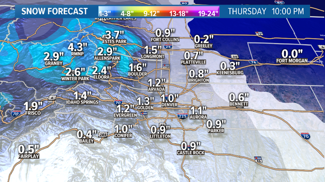
At some point the cold column will win out, and the rain will turn to snow. Hard to say when this will happen, but somewhere between 8 and 10am is most likely.
I think people will be surprised about just how heavy this snowfall will be once it turns. Between 10am and 3pm there is a chance for some good snow and this will most likely be focused in and around the Denver metro.
Snow totals will likely be in the 1-2" range for most of us. Some foothills and Palmer Divide locations could go over 2 inches of accumulation.
It is very possible that the north I-25 corridor between Thornton and Ft. Collins stays to warm for any accumulation. Likely no accumulation on the eastern plains either.
El Paso County could get the cold air and end up with an inch or two of snow. Better chance in Teller County though.
Even with some brief heavy snowfall, I wouldn't expect there to be any advisories issued.
Light snow could continue on and off on the Front Range until about 6 or 7pm before completely exiting the state.
Chance of snow in Denver: 95%
Dec. 7-9
This one still looks like mostly a mountain storm, but holding on to a slight chance for a little snow on the plains.
The latest runs of the GFS and Euro do not show snow accumulation on the Front Range, but they show a significant hit on our mountains with 6-12" of snow. That includes the I-70 mountain corridor so there's a good chance we'll see some Winter Storm Warmings in our part of the high country.
Looks like the majority of that snow will come on Sunday night and Monday morning. If the Front Range does get a chance at some snow, it will likely come on Monday morning.
Chance of snow in Denver: 0%
Dec. 13-15
This storm has been trending further and further northeast of Colorado, and it is possible this one will have no real impact on the state of Colorado.
Chance of snow in Denver: 0%
Dec. 16-20
GFS is showing several storms during this time period, but none of them close enough to have much of an impact on Colorado. The GFS on it's last 2 runs is showing only the snow we get Thursday morning all the way through December 14.
---
Tuesday Update:
Dec. 4-5
Still waiting for the Pacific Ocean to throw a fast moving southern storm at Colorado. Timing has changed back and forth a few times over today's model runs. It should move into Colorado by tomorrow morning.
This storm will have most of it's impact on southwestern Colorado.
Snow showers will start in the San Juans and slowly spread to the rest of the Western Slope throughout the day Wednesday. Not too much to the east of the Continental Divide.

Then by Thursday morning, the precip will spread to the Front Range. Probably a mix during the morning drive. Some rain, sleet, and maybe snow. Could turn to all snow at some point during the later part of the morning commute or just after.
Snow could be briefly heavy on the Front Range but doubt it will last long. Storm should be gone by 5pm. Could still get accumulation of an inch or two, especially in spots where there is already snow on the ground.
The GFS continues to show no accumulation other than the foothills south of I-70.

There might not be any advisories issued for this little storm, but I wouldn't be surprised to see a few pop up tomorrow. Could see 3-6" on the passes in the San Juans, and 2-4" in the central mountains.
Mostly 0-2" on the I-25 corridor between Colorado Springs and Cheyenne, and nothing for the eastern plains. A few foothills locations could get up to 2 inches. There does not appear to be much of a freezing rain threat, although the simulated radar products are still showing some of that on Thursday morning.
Chance of snow in Denver: 55%
Dec. 7-9
This storm still looks like a decent mountain storm bringing 5-10 inches to some spots. There should also be some snow on the plains where the GFS is still showing between 0-2"
So far the timing looks like it will start snowing in the mountains late Saturday night and continue to snow into Monday afternoon. It's not favoring any region over others at this time.
And the timing on the plains so far shows snow possible between 6am and 2pm.
Chance of snow in Denver: 0%
Dec. 13-14
This storm is still in the modeling but has been trending later. Looks like just some light mountain impacts so far.
Dec. 15-19
No strong signal in here yet.
--
Monday Update:
Dec. 3
Snow is starting to move into the northern mountains Monday night, but it looks like it will be very light in nature through the night, and into Tuesday morning. Probably be hard pressed to find a place with more than 3 inches of accumulation on the high mountain passes.
There is a slight chance of some freezing fog and drizzle on the northeast plains late tonight and tomorrow morning.
For the Denver area, we will likely wake up to full sunshine immediately in the morning.
Chance of snow in Denver: 0%
Dec. 4-5
Another storm will move in off the coast of Southern California on Wednesday and head towards southern Colorado. This one will also have some minor impacts to the Denver area.
Snow moves into the San Juans on Wednesday morning but should stay pretty light until the evening wave. There is not an advisory out for this storm yet, but it is possible as 4-8" are possible on the mountain passes in southwestern Colorado.
Precipitation moves onto the Front Range by Thursday morning. This could be a mix, before it has a chance to turn over to snow. Best chance to get some accumulation around Denver will probably be the south and southwest metro.

The GFS shows between 0-1" and the Euro shows between .5-2".
Better chance of getting more than 2 inches might be in the south Jefferson, Douglas, El Paso, and Teller County foothills.

Overall pretty low impact. I don't expect any advisories in the Denver area, unless a freezing drizzle threat emerges. Or possibly around Summit County because the Euro is showing a chance for 3-6".
Storm moves out Thursday evening.
Chance of snow in Denver: 25%
Dec. 7-9
This storm is still showing up in the modeling. It will most likely be a mountain event with little impacts to the plains.
Models show a few inches throughout the Rockies, but only scattered snow accumulation in the metro areas, and the eastern plains. Advisories will be possibly with this one, but not likely on the plains.
Chance of snow in Denver: 0%
Dec. 12-13
Models have been showing another possible southern storm. No consistency with any impacts to the Denver area.
--
Dec. 2-3
The first snowstorm of the winter will arrive Monday night. This will pretty much be a light mountain storm. No snow for the Denver metro area.

The bulk of this storm will miss Colorado well to the northeast, but we'll still get a little action. Snow will start in the northern mountains Monday afternoon, and they could end up with 1-4" in places like the Park Range, Rabbit Ears Pass, Rocky Mountain National Park, and maybe parts of the Indian Peaks, by Tuesday evening.
There will be less snow in the Central Mountains but places like Loveland Pass, Vail Pass, and Berthoud Pass could get a couple inches.
There won't be much impact to the southern mountains.
The northeast plains should be on the lookout for the possibilty of some freezing fog and freezing drizzle late Monday night and early Tuesday morning. This is very unlikely near the Interstate 25 metro corridor.
With gusty winds, ground blizzards are possible as well. The winds are not expected to reach thresholds that would require an advisory though, except maybe in southeastern Wyoming where a Warning is currently in place for this upcoming storm.
Denver could get a brief shallow layer of fog which sometimes results in flakes, but that is quite unlikely.
Chance of snow in Denver: 1%
Dec. 5
There is another winter storm loading up off the coast of California. That one is forecast to move across southern Colorado on Thursday. This one will probably have not have too much impact on the Denver area, but could bring 3-6" of snow to the San Juans.
Timing for most of the snow will be Thursday morning. Light snow will also be possible in the central mountains.
For the metro, the GFS is showing temps too warm for snow, but the Euro does show some light snow accumulation Thursday morning.
Chance of snow in Denver: 5%
Dec. 7-9
This storm is likely to be the next significant storm for the Colorado mountains, and will also bring a chance for some snow in the Denver metro.
The GFS solution is a little funky showing a split jet stream so this forecast could chance often over the next week.
It currently shows some mountain snow on Saturday, with some light snow spreading down to the plains by Sunday night. So far most of the solutions on this storm only show 0-2" in Denver, but it is signalling snow totals in the mountains over a foot.
With the storm still 6 days away, and some runs showing no snow in the metro, the chances remain low for now.
Chance of snow in Denver: 0%
Dec. 11-13
Models have been showing a storm in this time frame that would have more potential to impact the Denver area with more than 2 inches of snow.
Dec. 14-17
Only weak signals showing for this window at the moment.
SUGGESTED VIDEOS | Science is cool