
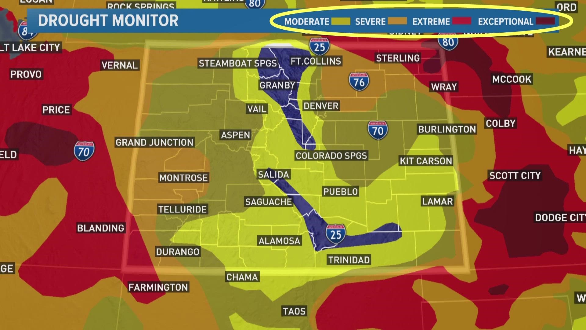
DENVER — This Thursday’s update to the U.S. Drought Monitor (USDM) showed two areas of slight improvement in Colorado. Both spots were in the northeast part of the state including almost all of Arapahoe County and part of the southwest Denver metro.
That was a reflection of the heavy rain that fell on Sunday and Monday.
Extremely heavy rain also fell on part of the northwest Denver metro this week but there was no change in drought conditions there. That's because this week’s drought update was already getting processed at that time.
There is a new drought update published every Thursday, which uses the data from the previous Monday through the current Monday. So the impact of Tuesday morning's rainfall will be reflected in next Thursday's update.
The USDM takes two days to draw up the map because it actually gets authored by a human scientist that makes a judgment by weighing several different factors.
The map does not come from a physical measurement from something like a drought sensor, or even from a computer model that just simply crunches data.
The author is either a climatologist or a meteorologist from the National Drought Mitigation Center at the University of Nebraska-Lincoln (the academic partner and web host of the USDM), the National Oceanic and Atmospheric Administration (NOAA), or the U.S. Department of Agriculture (USDA).
They usually take turns authoring two consecutive weeks of monitoring before handing it over to another author.
Precipitation is one major factor they consider but it's not everything.
They also consider temperatures, evaporation rates, soil moisture, streamflow, reservoir levels, and vegetation health to name a few.
Altogether they use more than 30 different indicators, but instead of publishing 30 different maps, they do their best to weigh all the factors and draw one single map that represents drought conditions in a way that’s easy to digest.
They put those drought conditions into 5 different classifications. Four different levels of drought severity and one near-drought condition they call Abnormally Dry.
They also have to consider both short-term and long-term drought conditions. The more time we spend in drought, the longer it typically takes to break it. So the improvements can seem slow compared to our perception of recent weather.
Feedback Welcome
The authors of the USDM welcome your input and observations. Here are four ways you can contribute to the way the weekly drought update is shaped.
1. Talk to your state climatologist - Colorado's is Russ Schumacher russ.schumacher@colostate.edu
2. Email the USDM authors at droughtmonitor@unl.edu
3. Become a CoCoRaHS observer - Submit drought reports along with daily precipitation observations to the Community Collaborative Rain, Hail & Snow Network.
4. Submit Condition Monitoring Observer Reports for the USDM authors to use.
SUGGESTED VIDEOS: Latest from 9NEWS