COLORADO, USA — So far only a trace amount of snow has been measured at DIA through Monday evening, but there are still a few more chances to get enough to measure. Even if it does't happen, I will probably start a new blog feed on Friday.
This will be updated once a day.
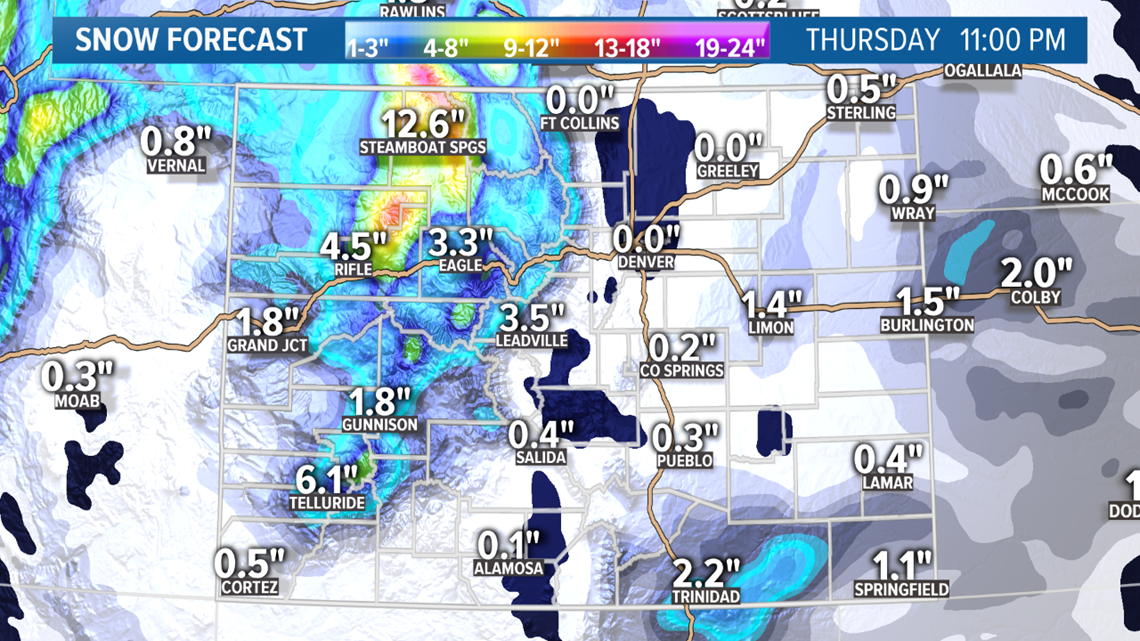
Sunday Update:
Jan. 28
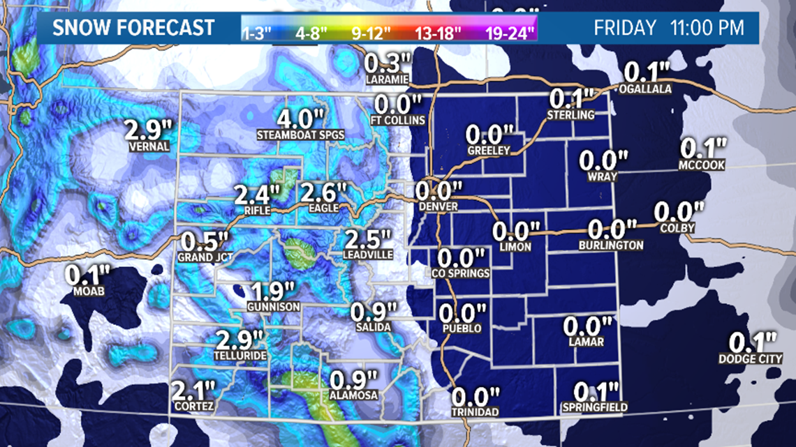
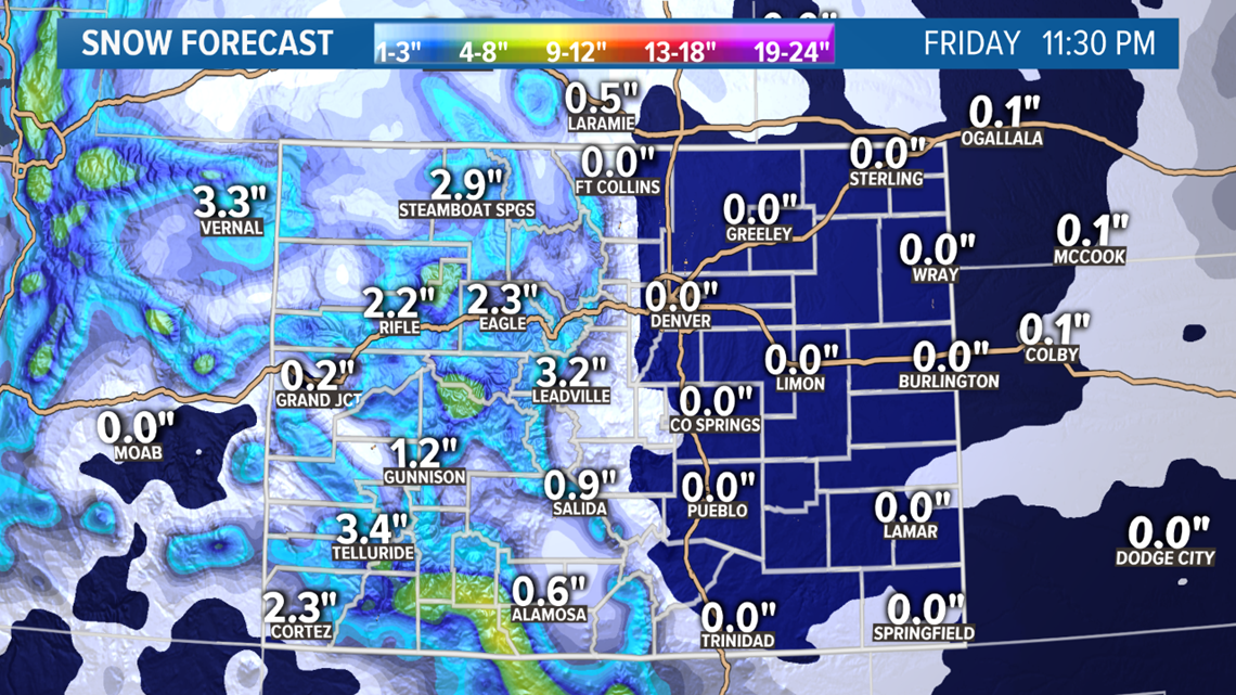
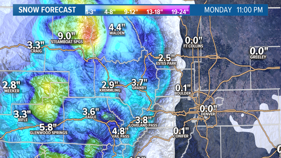
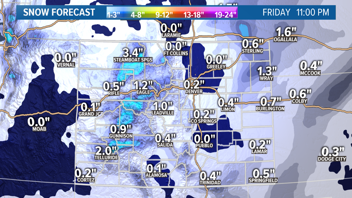
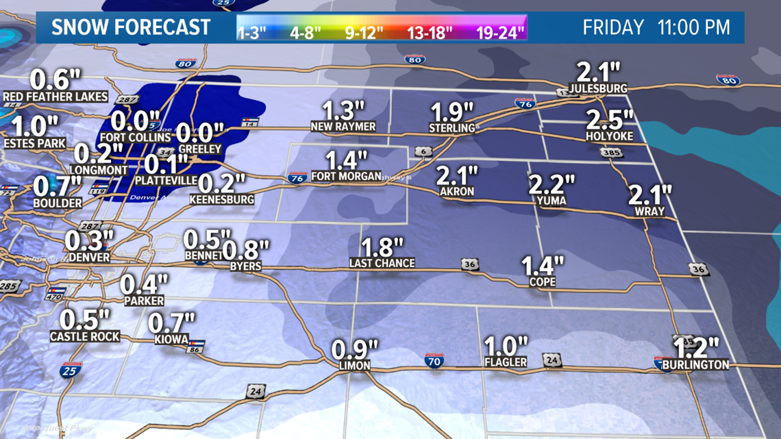
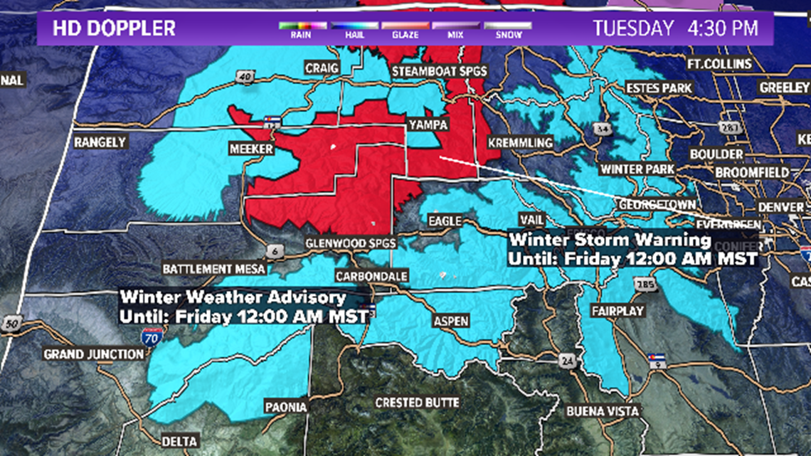
At the time of this post on Monday evening, DIA had measured .13" of melted snow, but not enough snow to get a measurement. So officially it still stands as a snowless January in Denver. There was however some measurable snow on in the surrounding areas of the metro, mostly to the south.
The system is moving out of the metro, but there is still some snow falling out near DIA, so we could hear about an actual snow measurement sometime tonight.
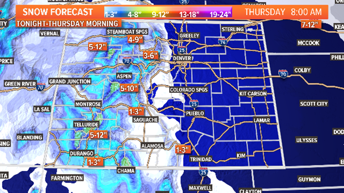
The storm will continue to drop snow on the eastern plains as it moves to the southeast though. Mostly between 1-3 inches of snow accumulation is likely going into Tuesday morning. Should exit by about 9am.
Some origraphic flurries will remain possible in the mountains tonight and into tomorrow as well. Maybe another inch or two up there.
Jan. 29-30
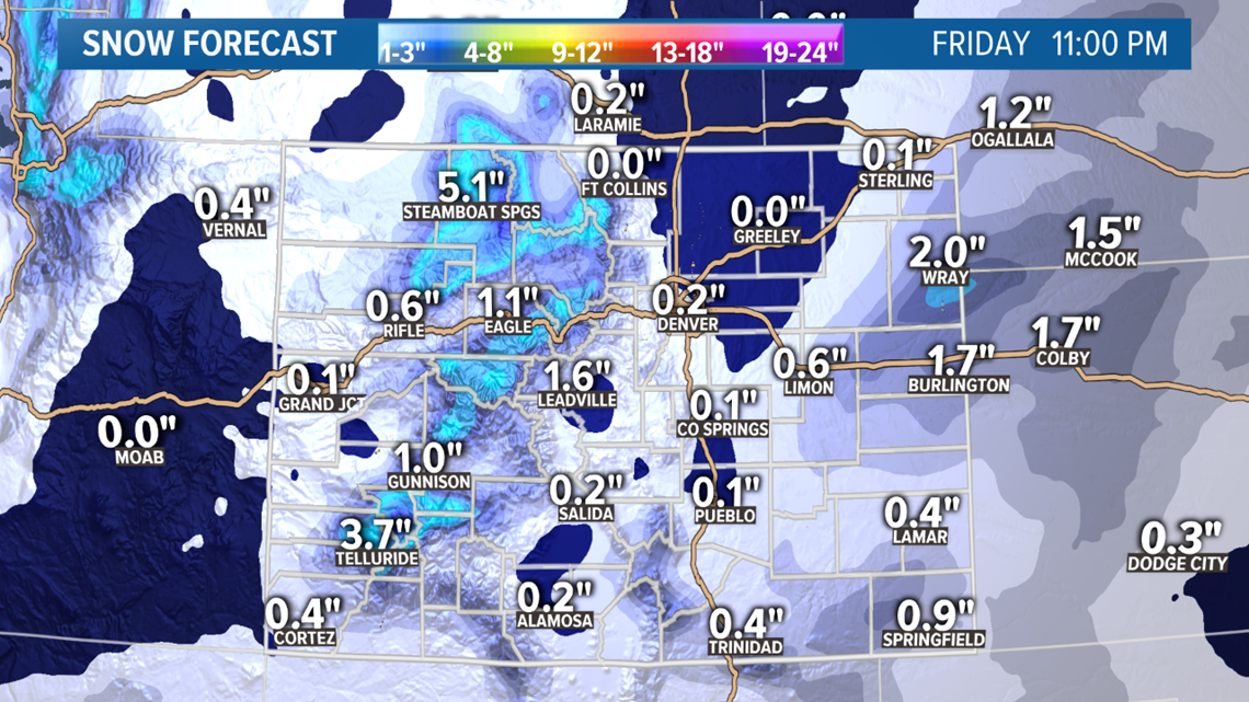
The next storm is moving in quickly behind this one. Snow will likely start back up in the mountains and Western Slope tomorrow night after just a short break.
Mostly just 1-3 inches up there except for maybe some of the southern peaks that could get 4 or 5 inches.

This storm will also bring the Denver area two more chances at some snow accumulation.
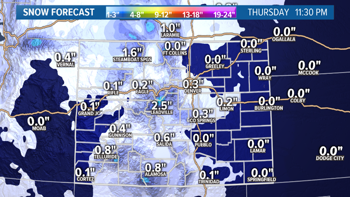
First on Wednesday morning. Snow showers will be pretty scattered so no too many places will see the snow in this first wave, but Denver could get scraped with a quick dusting of just under a quarter of an inch.
The the upslope winds fill in a little bit better just after sunset. That will give Denver another shot at some snow. I would say up to an inch is possible as the snow will be possible into the early morning hours on Thursday . Some parts of the foothills could get more than an inch and up to 3 inches.
Not much on the eastern plains with this one.

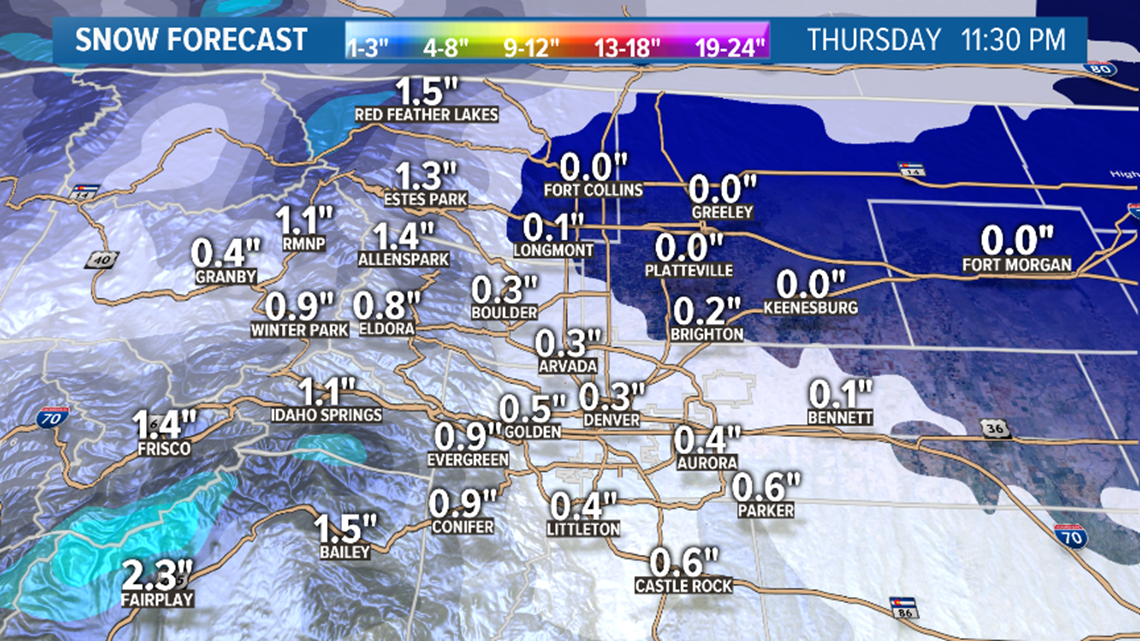
Then yet another fast moving system rushes through on Thursday night bringing an inch or so to the mountains and another shot for some light snow in the metro.
Chance of snow in Denver: 65%
Chance of accumulation in Denver: 30% (likely less than an inch)
Feb. 3-4
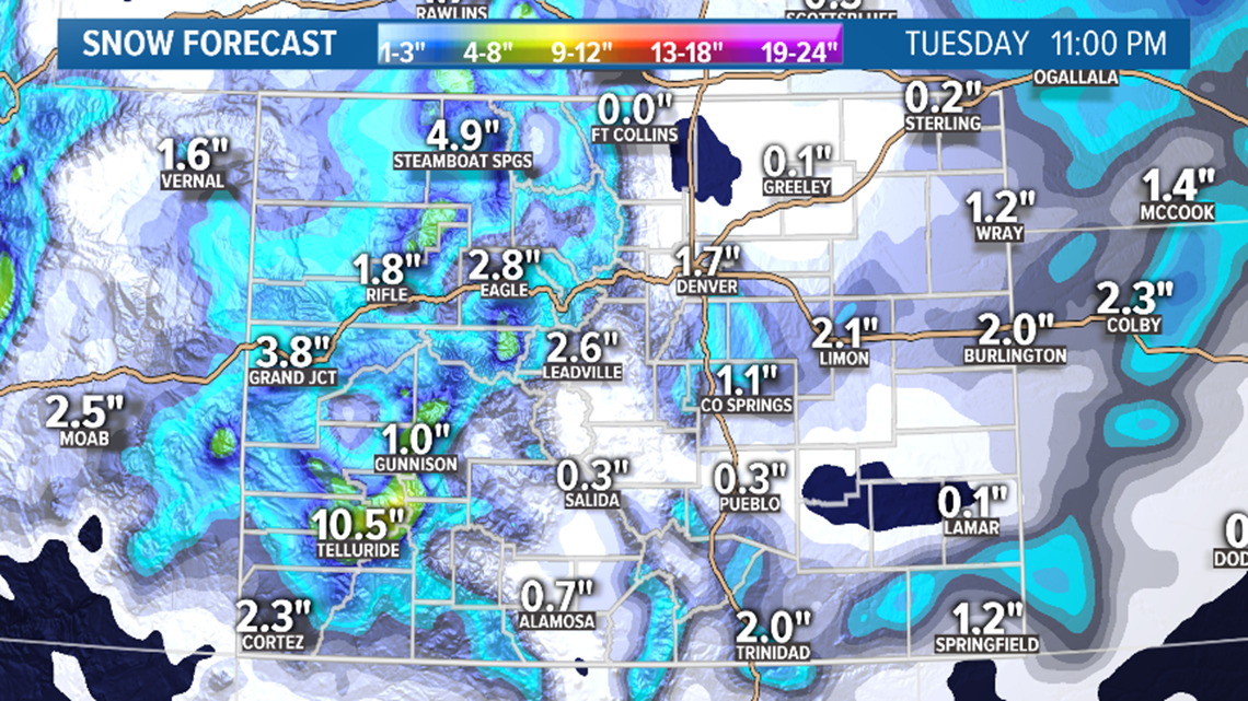
Coming off an unseasonably warm weekend on Superbowl Sunday where Denver might be chasing the first 70 degree reading of the year, the first storm of February moves into the state.
The signal is growing stronger at the moment for snow in the Denver area. So far the models area showing 1-3 inches on Monday Feb. 3.
It's showing roughly 3-6 inches in the mountains, with the San Juans getting the most, closer to 8 inches.
Chance of snow in Denver: 10%
Feb. 6-8
Models are showing a little clearer solution on this northern storm track brushing the state now. This could have some impact on the Denver area.
Feb. 9-12
Models are showing 2 weak systems in the window but no impact to the Front Range yet.
-------
Saturday Update:
Jan. 27-28
Looks like this storm will finally deliver some precipitation for us on the Front Range. We are an arid region but rarely do we have to wait 30 days in between waterings.
It is quite possible that many of us won't get any actual snow accumulation, but at least we'll see some snow falling out of the sky at times. The temperatures in the Denver metro may not drop below freezing the whole day so if the precip is snow it will likely melt fast, even on the grass.
Models are showing as much as a tenth of an inch of water available, so it is possible parts of the metro could get up to an inch of snow if local conditions are just right.
I would say the city of Denver will get zero accumulation, but DIA has a chance to get a tenth of an inch to maybe as much as a half inch of snow. If anybody in our region has a chance to get up to 2 inches, it would be somewhere on the Palmer Divide from Franktown to Limon, or Ute Pass between Manitou Springs and Woodland Park.
Timing will be everything to capitalize on the coldest temps. So there will be a few hours just after sunrise Monday to get some snow, then again in the evening after sunset. If the bulk of the precipitation arrives during the day, then all we will get is some light rain.
So far the models do show snow around 7am lasting to about 10am. Then they show snow from 6pm to 10pm.
Mountains are not expecting much out of this. Maybe 3-5 inches in select areas. There will probably be light snow falling in the high country Tuesday, but nothing down low.
Chance of snow in Denver: 65%
Jan. 29-31
Looks like there will be two training systems right behind the first one. That will give the Denver metro two more chances for snow.
Wednesday looks like enough for accumulation. Probably about a half and inch to an inch. Foothills could get a couple more.
Thursday looks more scattered and light, so snow accumulation will be more difficult.
Light snow possible in the mountains Friday.
Chance of snow in Denver: 45%
Feb. 3-4
After maybe chasing a 70 degree day in the Metro on Superbowl Sunday, a quick scraping system comes in with little impact.
Feb. 5-10
A little different solution by the GFS today showing several storm systems in and around the state in this window. Because it's a completely different look than 24 hours ago, we'll just have to table this and maybe start fresh if there is any consistency with it tomorrow.
-------
Friday Update:
Jan. 25
The bulk of this storm will be wrapped up by about noon Saturday. Mostly 1-3 more inches of snow in the mountains, with maybe 4-6 up on some of the high peaks.
Very low chance at a shower making it to the lower elevations. If that happens, it will just be a dusting of less than a half inch. Nothing for the Denver metro.
Chance of snow in Denver: 1%
Jan. 27-28
The models have held together for another day with this storm. Looks like a great chance to break our dry spell, although I don't think anyone will actually be impressed by this storm.
Still looks like mostly near 1 inch or less in the Denver metro area. A little less to the north and northeast of Denver. The south metro and Palmer Divide could get more than 2 inches but models do not show that to be very widespread.
Temps will be pretty warm in the metro area so the snow could be pretty wet. Look for accumulation to start just after sunrise on Monday morning as per current model guidance.
The northern foothills could get an inch, but maybe a little more in the southern foothills like Ute Pass and Teller County. Could get a couple inches there.
The most snow will likely be in the Sangres and Wet mountains where there could be 3-6.
Doesn't look like anything too great for the mountains but a few spots could get 3-6"
Chance of snow in Denver: 55%
Jan. 29-31
A trailing system following close behind will also bring a chance at some snow in the metro. It will probably be less than the first one if it happens though. So far models show snow .
Chance of snow in Denver: 15%
Feb. 2-3
This system is still in the modeling today. Showing as a quick and weak one with little impact.
Feb. 5
Another quick a weak system showing here with little impact to Colorado.
Feb. 7-9
GFS showing two systems in this window. Nothing interesting yet.
--------
Thursday Update:
Jan. 24-25
The next storm will move into the Colorado high country on Friday evening, and last into Saturday morning. Looks like about 1-3 inches of snow possible favoring the northern mountains. Probably no alerts will be issued by the National Weather Service for this storm.
Very low chance of snow at the lower elevations. A couple models show some snow accumulation in the Teller, Douglas, and El Paso County foothills near Deckers area. About a half inch of snow possible.
Chance of snow in Denver: 2%
Jan. 27-28
Still looking good for a weak surface low to develop under a trough on Monday and Tuesday. This will likely bring some weak upslope to the Front Range and possibly break this 26 day long dry spell.
Doesn't look like it will be much snow. Models are showing 0-2 inches of snow in the metro Monday night. Could be a little more than 2 inches on parts of the Palmer Divide.
Not much has changed in today's modeling. The GFS is still showing the low as weak and as far south as Amarillo. Euro has it slightly more north and a just a little stronger, but still a weak system overall.
Not enough momentum today to raise the chance of snow in Denver. The GFS even dropped a snow solution for Denver in a couple of it's runs.
Chance of snow in Denver: 40%
Jan. 29-31
The GFS has this storm as a jet split with the northern branch close enough to bring a few more inches of snow to the metro. The Euro has this storm as a southern track with little impact to the metro.
Chance of snow in Denver: 5%
Feb. 2-3
This storm has been backed down greatly in today's runs. Back to just a quick and weak mountain disturbance. Euro has a strong ridge at this time with highs in the 60's around the Denver area.
Feb. 4-8
Two systems being shown in this window today. Both with some impacts to the Denver area. That's two days in a row with metro snow showing in this timeframe.
--------
Wednesday Update:
Jan. 23
Thursday: Scattered flurries in the mountains. Could get up to an inch or two in the mountains, but nothing for the Front Range or eastern plains.
Chance of snow in Denver: 2%
Jan. 24-25
There will be a weak shortwave move through the state in between systems that could bring another inch or two to some parts of the mountains Friday and Saturday.
Very low chance at seeing a shower below 8,000 feet. If it happens it will probably be a couple drops of rain.
Chance of snow in Denver: 0%
Jan. 27-28
Models are still bringing a fairly weak surface low in the southeastern Colorado and Oklahoma Panhandle region on Monday. This will be able to bring some upslope winds to the Front Range and finally break this long dry spell on Monday and Tuesday.
Still 5 days out, but when the Euro is this consistent, the confidence in a snow forecast rises greatly. The GFS is also showing this system, but not as strong and a little bit further out of position. That is still somewhat of an agreement though.
The Euro has snow making it to the Front Range late Monday afternoon, with the heaviest accumulation around midnight, and continuing on into Tuesday. Could get pretty warm on Monday before the front arrives.

It shows between a half inch to 2 inches of snow in the metro. Not much, but it would be the first snow accumulation since the last week of December. So far the solution shows a very weak upslope push, so the foothills would not get much more than the metro out of it if this solution holds, but the Palmer Divide between Castle Rock and Limon would be the winner with 3-6 inches possible.
The mountains would not see much out of a system like this but could get 3-6 inches in spots.
The GFS does not show widespread snow in the Denver metro, but it does show up to an inch of snow in some spots. With it's further south solution, it has the Sangres with the most with 3-6 inches.
Still a lot of time, but this is still very promising after today's modeling.
Chance of snow in Denver: 40%
Jan. 29-31
Both models show a couple of quick trailing systems that would once again bring a slight chance at some light snow in the metro areas. Some modest snow in the mountains as well
Chance of snow in Denver: 5%
Feb. 2-3
The GFS stepped up the storm system in this window, showing much more snow in the mountains, and a little bit in the Denver area as well. This is only the first run it's done this, so we'll have to watch it for some consistency tomorrow.
Feb. 4-7
Still a system showing in this window, but it remains a weak signal with little impact to Colorado.
--------
Tuesday Update:
Jan. 22-23
Wednesday: Another 1-3 inches possible in the mountains. A slight chance of seeing a few rain, snow, and graupel showers in the Denver area, foothills, eastern plains, and Palmer Divide Wednesday evening or even Thursday morning, but snow accumulation is not expected.
Thursday: Scattered origraphic flurries in the mountains. Could get up to an inch or two in the mountains, but nothing for the Front Range or eastern plains.
Chance of snow in Denver: 5% (just quick rouge showers with little to no accumulation)
Jan. 27-29
This system is continuing to gain some momentum. The Euro remained consistent about showing snow in todays runs, and the GFS is starting to come around with a better position on it. Although it dropped that agreement in this evenings run.
This is a very good sign overall though, and it is starting to look like we will break this dry spell in the Denver metro.
Chance of snow in Denver: 25%
Jan. 30-31
This system is showing in the GFS for the third day in a row. Some impacts to the Front Range possible. Doesn't look big at this point.
Chance of snow in Denver: 0%
Feb. 1-6
GFS is showing a couple of quick low impact systems in the window.
------
Monday Update:
Jan. 20-23
Monday: A wave of snow showers moves through the high country bringing maybe as much as an inch of snow on a few of the high mountain passes. No alerts have been posted for this.
Tuesday: Another 1-3 inches possible in the mountains, with more to the south. A few mixed rain and snow showers will likely move across the Front Range and eastern plains on Tuesday but accumulation of snow is not likely.
Wednesday: Another 1-3 inches possible in the mountains. A little better chance of seeing a few rain, snow, and graupel showers in the Denver area, foothills, eastern plains, and Palmer Divide Wednesday evening, but snow accumulation is not likely very widespread.

Thursday: Scattered origraphic flurries in the mountains and maybe parts of the Front Range. Could get up to an inch in the mountains, but probably no accumulation on the Front Range or eastern plains.
Chance of snow in Denver: 10% (just quick rouge showers with little to no accumulation)
Jan. 27-29
Interesting modeling with this storm. This time it is the Euro calling for snow while the GFS is saying to pump the breaks. It is different when it's the Euro leading the charge though. Both runs today showed a storm system with upslope coming on Monday.
It is a disagreement all the same though, so for that reason I'm not getting too excited over it.
Chance of snow in Denver: 10%
Jan. 30-31
This system is showing in the GFS again today. Some impacts to the Front Range possible.
Feb. 1-5
GFS has at least one storm in this window. Nothing special though.
------
Sunday Update:
Jan. 20-23
Monday: A wave of snow showers moves through the high country bringing maybe as much as an inch of snow on a few of the high mountain passes. No alerts have been posted for this.
Tuesday: Another 1-3 inches possible in the mountains, with more to the south. A few mixed rain and snow showers will likely move across the Front Range and eastern plains on Tuesday but accumulation of snow is not likely.
Wednesday: Another 1-3 inches possible in the mountains. A little better chance of seeing a few rain, snow, and graupel showers in the Denver area, foothills, eastern plains, and Palmer Divide Wednesday evening, but snow accumulation is not likely very widespread. I could see areas near the Boulder County foothills getting a half inch to an inch, and the Palmer Divide as well.
Thursday: Scattered origraphic flurries in the mountains and maybe parts of the Front Range. Could get up to an inch in the mountains, but probably no accumulation on the Front Range or eastern plains.
The GFS showed 3 or 4 inches of snow possible on the far eastern plains, but it has conformed with the Euro and no longer shows much snow accumulation out there.
Chance of snow in Denver: 10%
Jan. 25
Models show a trailing system but way down in Mexico so no impact to Colorado. I'll drop this storm from coverage tomorrow.
Chance of snow in Denver: 0%
Jan. 27-29
The GFS has shown some on and off in Denver with this system, and today it came in range of the 9k Euro. On it's first run at 12z it also showed snow in Denver.
One run doesn't mean too much 9 days out, even coming from the Euro, but this is a good basis for building some good forecast confidence. This will be a good one to watch because it will be our last chance to pick up our first snow of 2020 in Denver if we don't get hit with one of the little squalls on Wednesday.
Chance of snow in Denver: 0%
Jan. 30-31
The GFS is however showing a trailing system that has some snow potential in Colorado.
Feb. 1-4
GFS has a storm in this window with a little impact to Colorado.
------
Saturday Update:
Jan. 21
This should be a fairly weak shortwave moving south of Colorado that will bring a light 1-4 inches of snow to the high country.
Chance of snow in Colorado: 0%
Jan. 22-24
The forecast on this storm system has not improved any today, and in fact, it is starting to look like the Euro's original signal of the main impulse moving too far south to impact Colorado may end up verifying.
Still could get some light snow in the high country, but as the solutions stand right now, there would be no snow accumulation in Denver, the foothills, the Palmer Divide, or the eastern plains.
Still some time for changes, but with only 4 more days to go, it's not looking great for Denver to break this dry spell.
Chance of snow in Denver: 10%
Jan. 25
This system is still showing in the modeling but is too far to the south to have any impact on Colorado.
Chance of snow in Denver: 0%
Jan. 28 - Feb. 1
The GFS is still showing 2 different storm systems in this window. The first looks fast a weak, but the second one is showing one final shot at January snow in Denver on Jan 31.
Feb. 2 - Feb. 3
Showing as clear
------
Friday Update:
Jan. 21
Weak impulse could bring an inch or two of snow to the mountains. Not really part of the following system. No alerts will be needed.
Chance of snow in Denver: 0%
Jan. 22-23
The GFS and the Euro are finally coming into some agreement on this storm. Both show it hitting with similar timing and similar intensity, but the Euro is sticking to more of a split impulse. One piece moving to the north and the other to the south of Colorado.
Still looks like Denver has a decent shot to see some snow accumulation with this system. It doesn't look like much, but it's our best chance in almost a month.
Both models are favoring snowfall on the Palmer Divide at this point, with between 1-3 inches in the Denver metro.
Chance of snow in Denver: 20%
Jan. 25
This system is now showing in both models. Not very impressive though. Maybe a little snow in the mountains.
Chance of snow in Denver: 0%
Jan. 28 - Feb. 2
The GFS is showing a series of storms in this window with little impact to the Front Range.
------
Thursday Update:
Jan. 16-17
Winter Storm Warnings and Winter Weather Advisories are scattered across the Colorado high country for a storm just moving into our area.
The focus of this storm will likely be in the eastern San Juans, but some other parts of the mountains should do pretty well.

Snow should go on pretty heavy in the southern part over the state overnight, while the northern parts of the mountains get the bulk of their snow starting Friday morning.


There will also be a wave of showers on the Front Range sometime late morning into Friday afternoon, but mostly just strong winds in the foothills and metro areas.
If they showers do sneak down low, they could be mixed with rain and sleet as temperatures could rise into the 50's quickly with those strong downsloping westerly winds.
Snow accumulation is not expected to be very widespread on the Front Range. Maybe a half inch or so in parts of the foothills.

Chance of snow in Denver: 10%
Chance of accumulation in Denver: 2%
Jan. 21
Weak impulse in front of a larger system could bring a quick inch or two to the Colorado high country.
Chance of snow in Denver: 0%
Jan. 22-24
There has been a little consistency with the timing of this system in the GFS now focusing on Wednesday night into Thursday morning. It has now shown snow in the metro 5 runs in a row, which is becoming a very strong signal.
It might not be too much in the way of accumulation, as temperatures may be a big issue for the first 12 hours of the storm, but the positioning of the storm is prime for upslope winds on the Front Range.
The Euro model though, is telling the GFS to pump those breaks. It shows this storm weaker and too far south to impact the Front Range of Colorado. It has been fairly consistent with it's placement but not as consistent as the GFS.
So overall, not the strongest signal between the two models for Denver snow.
Chance of snow in Denver: 15%
Jan. 25-26
This is a system that is only showing in the Euro. It could be the same signal that the GFS is picking up on for a few days prior because the Euro does show some metro snow with this one.
Jan. 27-31
The GFS is showing two storm systems moving past in this time-frame today. This would be a flip from yesterday where it was showing clear.
-------
Wednesday Update:
Jan. 16-17
There is a Winter Storm Watch out for the eastern San Juan Mountains for this storm that starts Thursday evening and goes through Friday night.
Probably see a Winter Storm Warning issued soon for at least the Wolf Creek Pass area.

A wave of showers should try to blast through the Denver area late Friday morning. It is possible for these to be snow showers, but the line will be thin if not broken, fast moving and light in nature, so accumulation is unlikely.

That line could be a little stronger through the foothills, and on the plains northeast of Denver, so up to an inch of snow will be possible there.
Chance of snow in Denver: 10% (most likely a wave sometime late Friday morning could bring a trace amount of snow)
Jan. 21
This could be just a really quick and weak shortwave in front of a larger system. 1-3 inches of snow possible in the high country.
Chance of snow in Denver: 0%
Jan. 22-24
The look of this window has changed drastically with every run and the GFS solution is quite different from the Euro from run to run, but the overall signal for a little upslope snow continues to shine through.
The GFS shows a strong southern storm track while the Euro shows a split jet with one piece of vorticity to the north and one to the south of Colorado.
Chance of snow in Denver: 10%
Jan. 27-29
This system made another appearance in today's modeling. Also looks like it may bring a chance for some snow on the Front Range.
-------
Tuesday Update:
Jan. 15
Light but still somewhat organized snow will continue in parts of the high country overnight until about sunrise Wednesday. Another inch might be possible in spots.
A few quick snow showers will be possible late tonight or tomorrow morning on the lower Front Range, but snow accumulation is unlikely. No models show any showers near the Denver area.
Chance of snow in Denver: 2%
Jan. 16-17
The focus of this storm will likely be the San Juans where another 8-18 inches will be possible in a short amount of time. Winter Storm Warnings will probably be posted by sometime tomorrow.
There should be some snow in the central mountains as well, but not much in the northern mountains.
There may be a few snow showers on the Front Range as well on Friday morning. Snow accumulation is not likely in Denver or at DIA, but some of the surrounding areas could get a little.
The Euro shows about a quarter of an inch to a half inch possible to the north and northeast of Denver.
Chance of snow in Denver: 5%
Jan. 21-22
This system is not showing too much impact in Colorado, but should be able to bring a couple inches to parts of the high country, favoring the southern mountains.
Chance of snow in Denver: 0%
Jan. 23-25
This storm is gaining some momentum with showing some snow in the Denver metro area. The GFS has shown at least a couple inches in Denver on 3 of the last 4 runs.
This would be next Friday, so still a long ways away, but at least there is finally something interesting to watch.
Jan. 27-29
This system did show up in the modeling again today, although it changed it's characteristics drastically from just 24 hours ago so we'll have to watch to see if it gains any consistency.
-------
Monday Update:
Jan. 14-15
It's been a decent stretch of mountain snow over the last 5 days with 2 more to go. This next surge comes in tomorrow evening and will be focused on the northern mountains.
Could get another 1-3 inches in Steamboat, and maybe another 1-2 inches on some of the mountain passes.
There is a slight chance a couple of quick showers make it down to the Front Range but snow accumulation is very unlikely. This would be late Tuesday night into Wednesday morning.
This long period of active weather will end before sunrise on Wednesday.
Chance of snow in Denver: 5%
Jan. 16-17
The hazard board is finally clear of all winter weather alerts but expect some more to be added for this next storm which comes into the state on Thursday evening.
The focus of this storm will likely be the San Juans where another 8-18 inches will be possible in a short amount of time. Winter Storm Warnings will probably be posted down that way.
There should be some snow in the central mountains as well, but not much in the northern mountains.
Still looks like snow around the Denver area will be unlikely. Maybe a few light showers on the eastern plains.
Chance of snow in Denver: 0%
Jan. 21-22
This system is still showing up in the models today. Looks like it might be capable of bringing some snow to the San Juans again, but not much in other areas.
Chance of snow in Denver: 0%
Jan. 25-26
This storm has not been showing up as a very potent storm, but it has brought the most consistent signal for upslope snow in the Denver area. It only shows snow accumulation here on 2 out of every 4 runs though.
Jan. 29-30
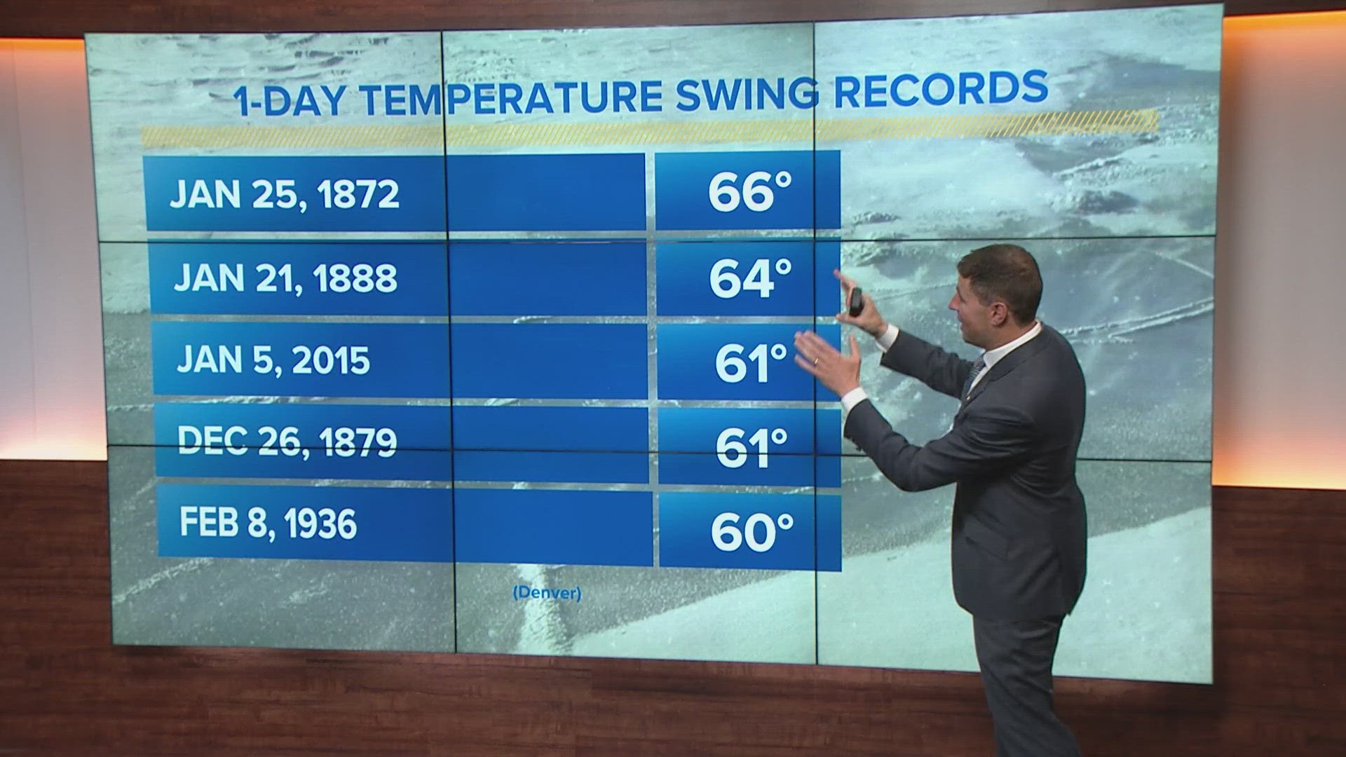
This will be one last chance to get measurable snow in Denver if it doesn't happen with the storm before this. Only twice in Denvers history has there only been a trace amount of snow in January. The last time being 2003. There has never been zero precipitation measured though, and that is where we currently are at, with no rain and only a trace of snow.
-------
Saturday Update:
Jan. 11-15
We are in the middle of Storm One out of three successive storm systems that will take us to Wednesday morning. Mostly this means modest snow totals for the mountains individually, but cumulatively they are resulting in a few winter storm alerts on the mountain passes.
Saturday: Light snow continues into the overnight hours. A few snow showers will make it down from the mountains tonight, but probably not much in the Denver area. The best chance for brief snow showers will be on the Palmer Divide or on the plains to the east of the metro. They'll be fast, so they'll only be capable of bringing about 1/2 inch of snow.
Sunday: 1-2 inches of mountain snow through the day. Maybe a mixed shower on the eastern plains on Sunday morning, but it does not look like the Denver area will get one of these. They'll will also be fast, so they'll only be capable of bringing about a half inch of snow.
Monday: 1-6 inches of mountain snow, mostly west of the Continental Divide. A few quick showers will be possible on the plains this day as well, but they'll be fast, so they'll only be capable of bringing about a half inch of snow.
Tuesday: 1-3 inches of mountain snow. Scattered snow on the Front Range and plains possible on Tuesday night, but not much in the way of accumulation.
Wednesday: As this storm train wraps up there could be another couple inches of snow in the mountains Wednesday morning, and another shot of snow on the Front Range as well, but it will likely be quick and not much in the way of accumulation.
Even though Denver will have a shot at some snow every day for the next 5 days, it is most likely that there will be no snow accumulation in the city or at DIA.
Chance of snow in Denver: 10% (Tuesday likely less than an inch)
Jan. 16-17
Looks like this next storm will come in after about a 24 hour break. So far it's been looking like a decent storm for the San Juans with 6-10 inches possible. Some other mountains areas could do pretty good as well.
Models have also been showing a shot at some snow in and around the Denver area on Friday, but it has only been showing less than a half inch.
Chance of snow in Denver: 0%
Jan. 21-23
Still a few small storm in this window, but not much impact to Colorado is shown.
Jan. 24-25
The GFS just popped a storm into this window in today's modeling. 2 out of the 4 runs has shown snow on the Front Range. The other 2 showed nothing.
Jan. 26-27
Clear.
------
Friday Update:
Jan. 11-14
The next winter storm is already moving our way and will start bringing more snow to the Colorado high country tomorrow morning. There are Winter Weather Advisories out for some areas, and a Winter Storm Warning for Routt County. These are for a 3-day storm period, as the snow will be pretty continuous with little breaks in between. Tuesday's storm may be added or addressed separately by the National Weather Service.

Saturday: 1-3 inches of snow for the mountains mostly west of the Continental Divide.
Sunday: 1-2 inches of mountain snow. Maybe a mixed shower on the eastern plains, but it does not look like the Denver area will get one of these.


Monday: 1-6 inches of mountain snow, mostly west of the Continental Divide.
Tuesday: 2-4 inches of mountain snow. Scattered snow on the Front Range and plains possible, but not much in the way of accumulation. No models showed any snow near Denver in today's runs.
Chance of snow in Denver: 10% (Tuesday likely less than an inch)
Jan. 17-18
This storm system is still showing in the models today, but the timing has sped up a bit. Still looks like 1-6 inches of mountain snow will be possible, with little to no impact to the Front Range.
Chance of snow in Denver: 0%
Jan. 21-23
Still a few small storm in this window, but not much impact to Colorado is shown.
Jan. 24-26
This window is shown as clear.
------
Thursday Update:
Jan. 9-10
Ended up making it into the upper 40's today along the Front Range, even though a weak cold front slipped through. Behind that front, the moisture is starting to build.
Could get a snow shower or a mixed rain/snow shower this evening just after sunset along the Front Range. Then a stronger front moves through very early Friday morning bringing another chance at a snow shower.

Snow totals are holding steady with about 1 inch of snow or less for most of the Denver area, Palmer Divide and Foothills. Best chance to get more than 2 inches would be on the plains to the east and northeast of Denver.

If we get snow during or just before the morning commute on Friday, the temps will be plenty cold enough for it to stick to the streets. Even a quarter inch of snow can make things slick.
No advisories anywhere in Colorado for this storm.
Chance of snow in Denver: 60%
Chance of snow accumulation in Denver: 20% (Likely less than an inch)
Jan. 11-14
This very active storm pattern continues to show one surge of polar air after another, so if you live in the Colorado mountains, it may just feel like several waves of snow over the next six days or so. Minimal impact on the Front Range.
Saturday: 1-3 inches of mountain snow. No advisories expected.
Sunday: 1-2 inches of mountain snow. Maybe a mixed shower on the eastern plains. Nothing for Denver.
Monday: 1-4 inches of mountain snow. No advisories expected.
Tuesday: 1-4 inches of mountain snow. Scattered snow on the Front Range and plains possible, but not much in the way of accumulation.
Chance of snow in Denver: 10% (Tuesday likely less than an inch)
Jan. 18-19
The GFS has refined this storm a little bit and shows 1-6 inches of mountain snow possible. It also shows flurries possible on the Front Range.
Jan. 20-21
And this would be the final trough in this long stretch of storms. Colorado looks like it will just come up on the short end of this pattern with several small mountain hits, and very little to show for on the Front Range.
Jan. 22-25
This window is shown as clear.
------
Wedneday Update:
Jan. 8-10
A winter storm is just moving into Colorado tonight. There are no advisories posted for this very weak system. It is actually comes in two different stages.
Light mountain snow tonight, and then another wave of light mountain snow Thursday night. It probably won't be until Friday until the Front Range can get some snow.

Very early Friday morning for some snow showers on the eastern plains. This is where the best chance at steady snow will be. The Euro is indicating a chance at 2-3 inches of snow in the counties along the Kansas state line.
These snow showers will not likely be too steady Palmer Divide, so less than an inch is expected there.
You may notice on snow accumulation model, that the Front Range snow hole is bigger today, and the over trend of the snowfall is going down.

There is a very high chance that the Denver metro area will not get any snow accumulation, although the Euro does show a quarter of an inch in the west and south metro. A quick shower will be possible anytime on Friday, but the morning and the evening would work best with temperature.
System moves out of the state by late Friday night.
Chance of snow in Denver: 25%
Chance of snow accumulation in Denver: 10% (Likely less than an inch)
Jan. 11-15
The signal for his stretch continues to show several different surges of polar air arriving one right after the other here. None of these disturbances look very interesting for Colorado.
It is quite possible that the Denver metro does not end up getting any snow out of this, and if it does, it will likely be less than an inch.
Chance of snow in Denver: 10% (Most likely less than 1")
Jan. 18-21
GFS is still picking up on a few more troughs in this window, but is only showing a chance for light snow in the Denver area.
Jan. 22-24
Clear in this window today.
------
Tuesday Update:
Jan. 8-10
Some warm temps are likely across the state Wednesday before our next winter storm moves in. The first surge of energy will be focused on the western slope Wednesday night and through the day on Thursday. Then snow will make it onto the Front Range and adjacent plains on Friday morning.
No alerts for the high country at this point, as just 1-4 inches of snow is likely, and winds should not be as big of an issue this time. There should be at least a wave of snow along the I-70 mountain corridor on Wednesday night, and then another one sometime Thursday evening.

Snow may start in the Denver metro just before sunrise on Friday morning. Models are still consistently showing less than an inch of accumulation for most of us, including the Palmer Divide.
Looks a few foothills locations could get a couple inches, but the best chance to go over 2 inches would be the plains to the northeast and east of the Denver area.

This storm should wrap up sometime last Friday night, but the next one will be coming in shortly thereafter.
Chance of snow in Denver: 55% (Mostly likely less than 1" Starting Friday morning)
Jan. 11-16
The signal for his stretch continues to show several different surges of polar air arriving one right after the other. A dominant or more clear signal for one of these days will likely emerge at some point, but that has not happened yet.
Still looks to be pretty low impact to Colorado either way though. Light to moderate mountain snow, with a slight chance at some light snow in the Denver area. Likely Tuesday or Wednesday at this point.
Chance of snow in Denver: 15% (Most likely less than 1")
Jan. 18-20
GFS was picking up on this signal again in today's runs, nothing too significant, but it has been showing another chance for snow in the Denver area with several separate systems.
Jan. 21-23
Clear in this window today.
---------
Monday Update:
Jan. 8-10
Colorado's next storm system moves in on Wednesday evening. Its actually several different surges of troughiness that will sweep down from Canada almost consecutively, but these first two are easy to separate out.
Should be able to deliver some snow to the Front Range but it still doesn't look like much at this point.
Wednesday and Thursdays snow should be contained to the mountains. Looks like 1-4 inches will be possible. Probably no advisories unless blowing snow becomes an issue again.

The snow should move down to the lower elevations by Friday morning. Models have been consistent showing less than an inch for the Denver metro, the rest of the I-25 corridor, the foothills, and the Palmer Divide.
The area with the best chance to get more than 2 inches is the plains just northeast and east of Denver.
Might not be much, but still planning on seeing some snow around here on Friday.
Chance of snow in Denver: 35% (Mostly likely less than 1" Starting Friday morning)
Jan. 12-14
Looks like a pretty short break before a couple more systems move in. Very similar to it's predecessor, it looks like modest mountain snow and very light snow in the metro areas.
Timing has changed with that for the third day in a row. Now showing Tuesday as the best chance in Denver.
Chance of snow in Denver: 20% (Most likely less than 1")
Jan. 18-19
This storm still showing as just mountain impacts.
Jan. 20-22
This window showed as clear yesterday, but has flipped now with the ridge to the east, and a light storm system in the west.
------
Sunday Update:
Jan. 5-6
A weak storm system is moving into Colorado this afternoon. Some modest snowfall is expected in the northern mountains. Mostly between 1 to 4 inches, but there is a Winter Weather Advisory out for parts of the high-elevated areas like Rabbit Ears Pass where 4 to 8 inches is most likely.
The advisory does extend into parts of the central mountains as well, mostly due to the likelihood of brief periods of low visibility from snow squalls and blowing winds Sunday evening.

There will be a few attempts tonight for some showers to slide onto the Front Range after about 6 p.m. These should be very fast and won't amount to much. Even if a few make it down, less than 5 percent of our population will see them.
Chance of snow in Denver: 2%
Jan. 8-10
This system will press further south and have more impact for the metro areas.
It looks like snow may start falling in the mountains on Wednesday evening. So far this system looks very weak, only capable of producing between 1-4 inches of snow in the high country.
Snow might not make it to the Front Range and the plains until Friday. If it comes through on Friday morning, the Denver area could get 1-3 inches of accumulation. If it comes in later in the afternoon, it will likely result in less than an inch of snow.
Either way, not a very impressive system. The models have been very consistent in at least showing some widespread snowfall for the Denver metro, so there's a good chance that many of us get to see some snow later this week.
Chance of snow in Denver: 25% (Mostly likely less than 1" Friday morning)
Jan. 12-15
This system is still showing up today, but it appears to be a longer lasting batch of cold air that could send a couple different waves of storms at us in this window.
Good chance that the Denver area will get at least a small dose of snow during this window. Does not look like a big deal at this point.
Euro has the best chance at metro snow on Monday, Jan 13.
Chance of snow in Denver: 10%
Jan. 18-19
This trough has been shown in the modeling for two consecutive days now. It does not show an impact to the metro areas.
Jan. 20-21
Clear
------
Friday Update:
Jan. 5-6
As light snow winds down in the high country this evening, the next storm will move in on Sunday afternoon. This is still looking like a pretty weak storm, so no winter weather advisories will likely be posted.
The Euro does show a couple of little mixed rain and snow squalls making it onto the plains on Sunday night, but snow accumulation is unlikely. That is the reason though that some snow is showing near Boulder, and out on the plains northeast of Denver.
There may be a high wind advisory issued for the foothills for Saturday as those downsloping westerly winds may get going pretty good. So far there is no indication that the National Weather Service will issue an advisory, but C-DOT will likely have a travel advisory out for the foothills.
Those winds could warm the Front Range up nicely though. A high of 60 degrees is possible for much of the Denver metro Saturday.
Chance of snow in Denver: 5%

Jan. 9-10
This storm system is still showing in the models with little change. Should be more of an impact for Colorado than but still pretty weak.
Looks like another 1-4 inches of snow for parts of the high country, and a slight chance for a quick shower making it down onto the plains.
The Euro and the GFS are both showing some quick snow on and around the Palmer Divide on Thursday night. Less than an inch though as the showers will probably move pretty quick.
Neither model is showing any snow accumulation in the metro area in today's runs.
Chance of snow in Denver: 5%
Jan. 12-14
This storm system is also still showing in today's modeling with little change. Still looks like the best chance for snow accumulation for the Denver metro area, although even that is not too impressive at this point.
Looks like 3-6" potential for the mountains, and 1-3" potential for the metro areas. Mostly likely timing for metro snow would be next Sunday Jan. 12.
Chance of snow in Denver: 5%
Jan. 18-19
Storm system in this window has been showing new in today's modeling.
------
Thursday Update:
Jan. 5-6
The next winter storm to watch comes in on Sunday night. This will be a weak disturbance moving to the north of Colorado. Looks capable of 1-4 inches of snow in the northern mountain passes. Likely no advisories with this storm.
Could send a backdoor cold front into the Front Range but not much impact for us though. Maybe a few scattered showers of mixed rain and snow. This would likely be Sunday night into Monday morning.
Chance of snow in Denver: 5%
Jan. 9-10
This storm system is likely to push deeper south which would increase the chances of snow at the lower elevations.
Doesn't look like it will be a very strong system. Based on today's modeling, there would be no advisories in the mountains or the plains with this storm, but we will have a chance to get a couple inches of snow in the Denver area and Palmer Divide.
Only the GFS is showing enough snow for accumulation in the city. Thursday looks like the most likely day right now for either rain or snow in the metro.
Chance of snow in Denver: 5%
Jan. 12-14
This storm is still shown in the modeling producing some snow in the Denver area on Sunday Jan. 12. So far nothing great, just a couple inches. My be a big enough storm for some advisories in the mountains.
Jan. 17
Nothing else shown until the Jan 17.
------
Tuesday Update:
Jan. 1-3
The New Year's Day storm is set to move into the northern mountains starting early Wednesday morning. Winter Storm Warnings and Advisories are posted for the Central and Northern Mountains.

In the mountain towns listed in the advisory, 5-10 inches of accumulation will be possible. The Euro is still indicating a chance of a little more in Steamboat Springs.
Steamboat Resort could get between 8-18 inches along with other parts of the Park Range, Elkhead Mountains, and Flattops. The bulk of the snow will come through the day on Wednesday but continue Thursday and Friday as well.

On the Front Range, it will be all westerly downsloping winds. It could make it up to 50 degrees in Denver by 2 p.m. with the help of those warm dry winds, but a few waves of showers will likely make it over the mountains.
RELATED: Mild weather to start the new year
The best chance for a mix of rain, sleet, and snow showers in the Denver area will be in the afternoon and evening Wednesday, although passing showers will be possible Thursday morning, and evening as well. They are just less likely.
Snow accumulation is not likely in the metro areas, the foothills, or eastern plains. I could see parts of the Palmer Divide getting between a half inch and an inch of snow on the ground from one of these squalls.
Chance of snow in Denver: 5%
Jan. 5-7
This storm is still shown in the modeling moving to the north of Colorado. It could bring some light snow to the northern mountains Sunday night through Tuesday morning.
Models are also still showing some snow in Denver on Monday afternoon. It does not appear to be a big deal at this point.
Chance of snow in Denver: 15%
Jan. 9-10
There are still a couple of quick storms in this window. Mountain impacts look possible. There are no consistent signals for the metro area. In the most recent runs, the GFS does not show snow in Denver.
Chance of snow in Denver: 0%
Jan. 12-13
Active storm pattern continues to be shown in the modeling. A storm has popped up on Jan. 12 with a little snow in Denver on the last couple runs.
Jan. 14-16
Another storm is shown close to Colorado in this window. No concerns at this point.
-----
Monday Entry:
Jan. 1-3
The next winter storm moves into Colorado on Wednesday morning. The focus will be the northern mountains but there could be some mixed rain and snow showers on the Front Range.

There are no warnings or advisories posted for this storm just yet, but that will happen soon. There are 10-16 inches of snow possible in a 48 hour period for the passes in the Park Range and Flattops.
We could even see a warning in the city of Steamboat Springs with as much as 12 inches being shown possible by the European model. That is also over a 48-hour period, but quite a bit of that could fall on Wednesday.

On the Front Range, it will be mostly westerly downsloping winds. This could even warm us up into the '50s on New Years Day. Those winds should be able to keep most of the snow off the Front Range foothills and metro areas, but modeling does show a few mixed rain and snow showers in the area both days.
The best chance to get snow accumulation in the Denver area would be Wednesday evening or Thursday morning, and then maybe another show on Friday morning. The character of these showers will likely be spotty convective showers as opposed to stratus layer snowfall. That will limit the coverage but could mean a heavy squall is possible in spots if the temps are low enough.
As of today, neither the NAM, Euro, or GFS are showing any showers heavy enough to give Denver snow accumulation, but the surrounding areas could get a little dusting.

A little more favorable wind profile could exist on the eastern plains where snow showers might become a little bit more organized. Most modeling has been showing 1-3 inches of accumulation possible. Same timing, mostly Wednesday night and Thursday morning. No advisories are likely outside of the mountains.
Chance of snow in Denver: 10%
Jan. 6-7
This appears to be a weaker northern storm track with some light mountain snow accumulation, but models have been showing a backing cold front possible which could bring some brief upslope to the Front Range.
So far it looks like just a couple inches will be possible.
Chance of snow in Denver: 10%
Jan. 8-12
The GFS shows a very active storm pattern in this window with several storms coming close to Colorado, but with little impact to the Front Range.
Jan. 13-15
No storms are shown in this window in today's modeling.
SUGGESTED VIDEOS | Science is Cool