VERIFY – YOU’VE GOT QUESTIONS, WE’LL FIND ANSWERS
A 9NEWS project to make sure what you’ve heard is true, accurate, verified. Want us to verify something for you? Email verify@9news.com.
THE QUESTION
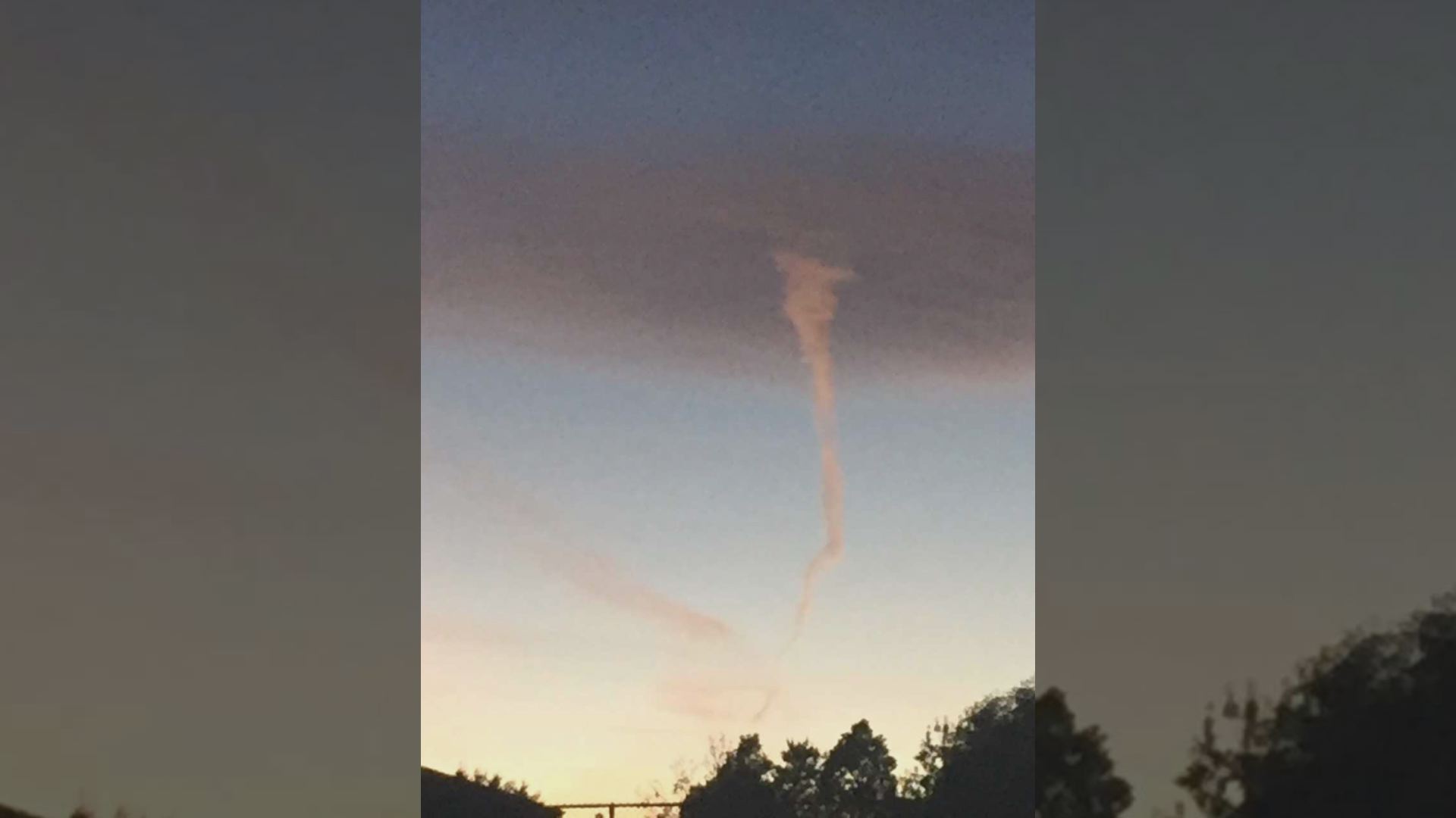
A viewer emailed 9NEWS Tuesday morning about something peculiar looming in the distance of their grandsons’ baseball practice in Aurora Monday night. The picture was taken at the Meadowood Recreation Center baseball field east of Chambers Road.
The following picture was attached to the email, which said the weather was calm at the time – the viewer asked if it could have been a tornado.
The 9NEWS Verify team and meteorologist Cory Reppenhagen determined if the pictured formation was in fact a twister.
WHAT WE FOUND
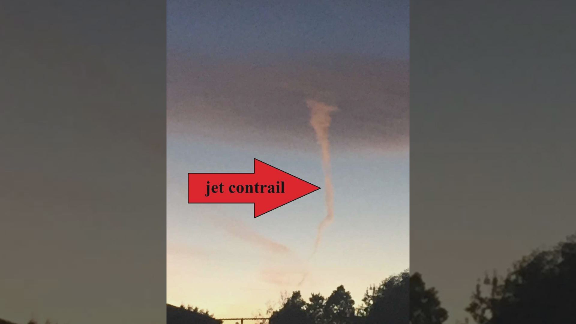
What appears to be a tornado in the picture was just an optical illusion, Reppenhagen said.
The part of the formation that looks like a funnel is actually a fading jet contrail.
The upper part is a lenticular cloud.
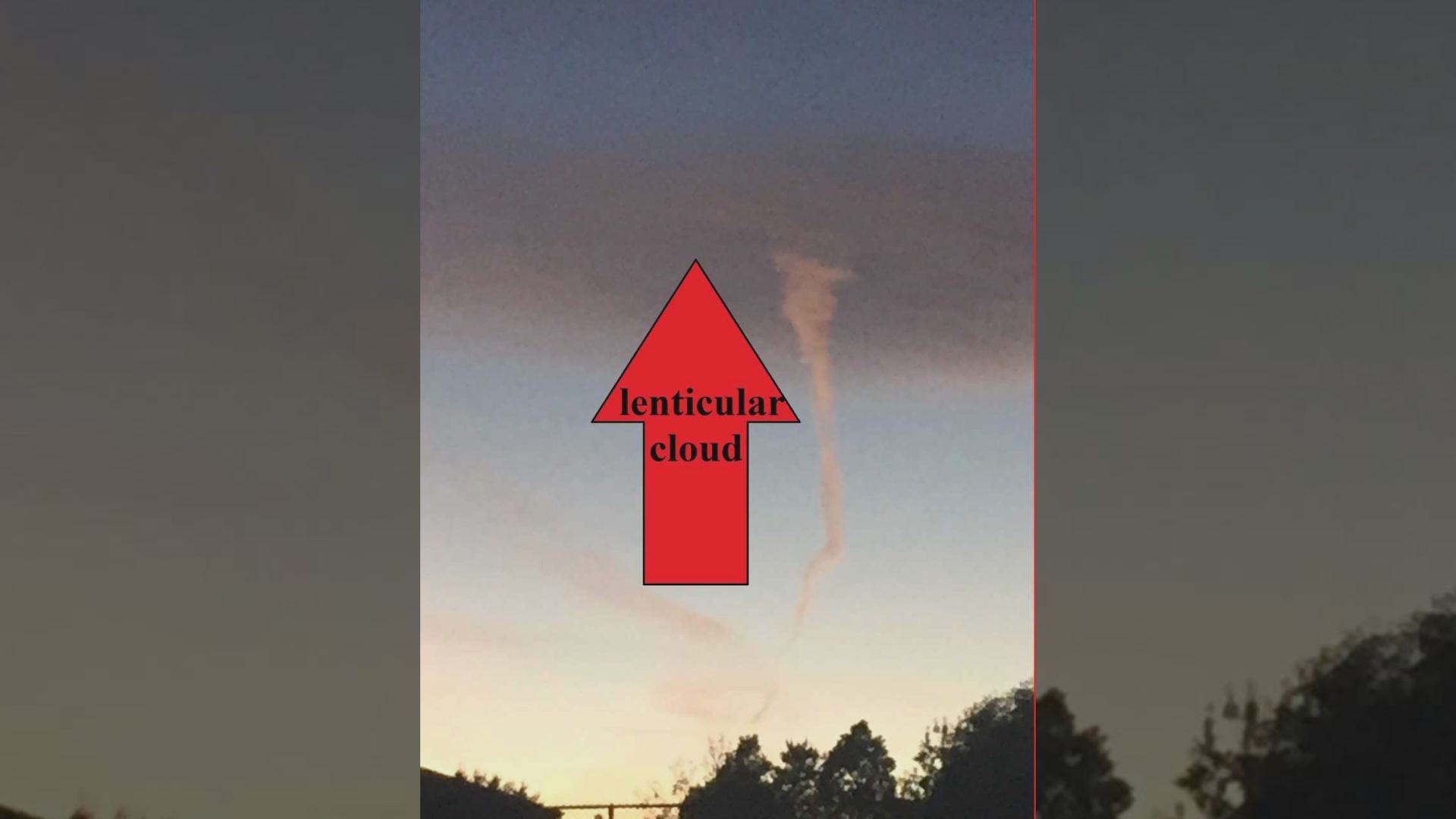
From the viewer’s vantage point, the formations looked like they were attached, but the two clouds were not actually connected.
Todd Dankers with the National Weather Service confirmed Reppenhagen’s explanation of the jet contrail and lenticular cloud creating the illusion of a tornado.
“There were no funnel clouds, no tornadoes in Aurora last night,” Dankers said.
HOW THE FEATURE FORMED
People who have been outside on a cold day know you can sometimes see your breath create a “cloud” – contrails form in a similar way.
“A contrail is the condensation trail that is left behind by a passing jet plane,” according to the National Weather Service. “Contrails form when hot humid air from jet exhaust mixes with environmental air of low vapor pressure and low temperature.”
Contrails become visible when there is condensation.
A lenticular cloud makes up the other part of the picture.
The National Weather Service defines these clouds as, “A very smooth, round or oval, lens-shaped cloud that is often seen, singly or stacked in groups, near or in the lee of a mountain ridge.”
This type of cloud has a history of being mistaken as flying saucers.
“These clouds form when stable air is pushed up by some sort of barrier, whether that’s a mountain or a building or an art installation,” according to the National Weather Service. “The air might cool as it goes up and then begin to sink because colder air is heavier than warm, creating a wave.”
Moisture in the air stacks together into vertical lenticular clouds.
NO RECIPE FOR A TWISTER
The cloud in the picture is not the type of cloud to produce tornadoes, Reppenhagen said.
Cumulonimbus clouds – also known as the thunderstorm cloud – are heavy, dense and can also produce hail and tornadoes.
“Cumulonimbus cloud, characterized by strong vertical development in the form of mountains or huge towers topped at least partially by a smooth, flat, often fibrous anvil,” according to the National Weather Service.
Tornadoes extend from the bottom of thunderstorms, and are attached to the cloud and the ground.
“The most destructive and deadly tornadoes occur from supercells, which are rotating thunderstorms with a well-defined radar circulation called a mesocyclone,” according to the National Severe Storms Laboratory.
HOW TO DISTINGUISH A TORNADO
The Storm Prediction Center listed the most important things to look for when you spot suspicious clouds:
- Rapid cloud-base rotation – if close enough to see cloud movement
- A concentrated, whirling debris or dust cloud at ground level under the thunderstorm base.
“It is common to have one without the other,” according to the Storm Prediction Center. “Many thunderstorms produce dust plumes in their outflow; these tend to move in one direction and not rotate. In gustnadoes, there is spinning motion at ground level but not at cloud base (therefore, not a tornado).”
BOTTOM LINE
The formation in the viewer’s picture was not a tornado, but two separate cloud formations that only appear ominous – ultimately posing no danger.