
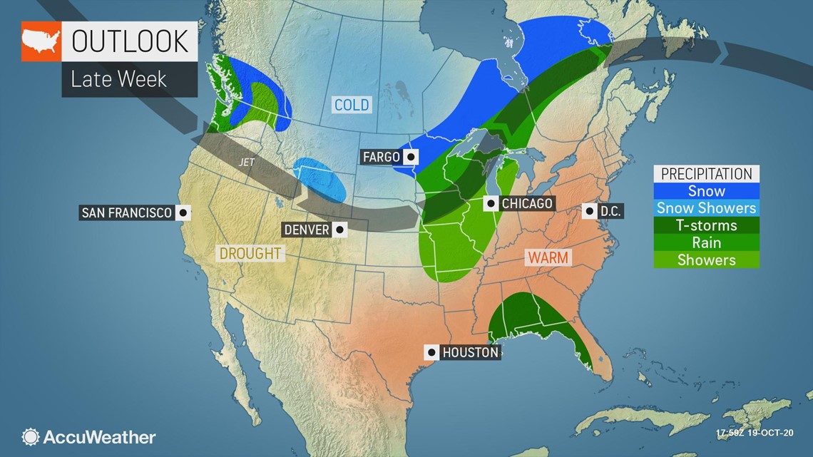
In true fall fashion, a late-week storm will unleash a variety of disruptive weather across the Central states, including more snow for the northern tier and the threat for feisty thunderstorms farther south where Old Man Winter paid an early visit mere days prior.
Multi-faceted storms, such as the one AccuWeather meteorologists are predicting to form and sweep through the nation's midsection Thursday into Friday, are not uncommon during the fall months. October and November can feature frequent and wild weather swings as summer and winter battle it out.
"This will be the type of storm that we often see in autumn and spring. There will be a surge of warm, moist air northward into the central Plains and Midwest and a press of cold air across the northern Plains," said AccuWeather Senior Meteorologist Mike Doll.
"There will be a risk for gusty thunderstorms in the warm portion of the storm and heavy snow in the cold portion, with a chilly, soaking rain in between," Doll said.

Snow to clog roads from Montana to Minnesota
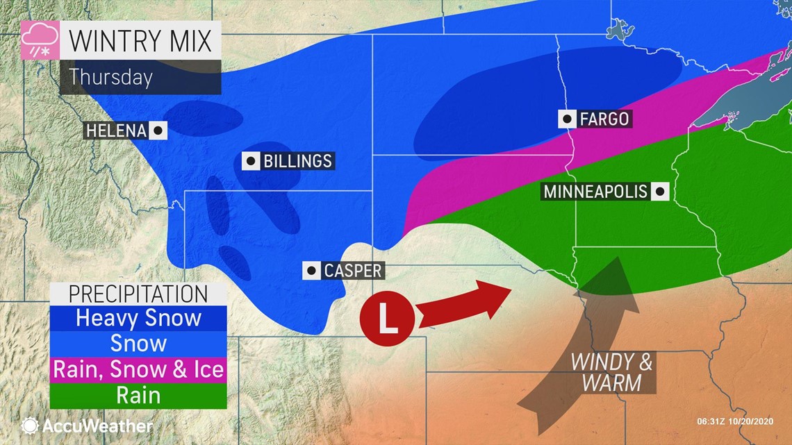
The northern and western fringes of the storm, where Arctic air from Canada will come into play, is where forecasters are expecting a travel-disrupting snow to fall.
A swath of more than 6 inches of snowfall is possible, with these high totals most likely across the northern Rockies, as well as in a corridor from North Dakota into northern Minnesota.
Sections of interstates 15, 29 and 94 may be at greatest risk for hazardous travel conditions due to snow-covered roadways and reduced visibility. Drivers may want to consider a more southern route if possible to avoid the wintry travel.
"Given how cold it's been, most of the snow will accumulate on the roads and make them slippery if untreated," Doll said.
Timing of the snow will be Wednesday into Wednesday night across Montana and Wyoming, and Wednesday night into Thursday night over the Dakotas and northern Minnesota.
Just to the south of the zone of heaviest snowfall, a narrow corridor of a wintry mix can occur.
Some places in the Midwest that received heavy snowfall earlier in the week will be on the rainy side of this storm.
For example, residents of Minneapolis can expect a chilly, soaking rain on Thursday, following a projected snowfall of 6-10 inches into Tuesday night.
Feisty thunderstorms may rumble over central Plains
Warm, humid air surging northward along the southeastern side of the storm may set the stage for heavy, gusty thunderstorms to develop late Thursday into Thursday night from portions of Iowa to Kansas and Oklahoma.

"The August derecho is fresh in the minds of Iowans, but the intensity of any thunderstorms in the state late Thursday and Thursday night will not come close to matching that event," Doll said.
In fact, it could wind up that the best forcing mechanism to produce gustier thunderstorms may wind up being too far to the north and west of the best severe thunderstorm ingredients in the Midwest, according to AccuWeather meteorologists.
In this case, there would likely be a period of drenching rainfall, but little to no severe weather.
"However, even without thunderstorms, there could be wind gusts of 40-50 mph in the Midwest and western Great Lakes, including Chicago," AccuWeather Meteorologist Jake Sojda said.

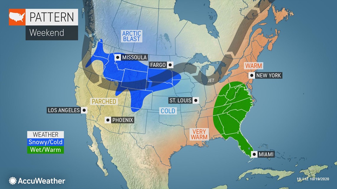
Temperature whiplash behind storm
Highs from Thursday to Friday can plunge by 35 degrees Fahrenheit as cold air rushes in behind the storm.
Omaha, Nebraska, and Des Moines, Iowa, will experience a drop from the upper 70s on Thursday, to the lower to middle 40s on Friday. Kansas City, Missouri, and Oklahoma City will be in the 80s on Thursday, but may only have highs around 50 at the end of the week.
The cooldown will not be quite as drastic farther east, but will still be noticeable for a place like Chicago, where 70s will be traded for 50s.
The core of the cold is expected to set up over Montana, Wyoming and the Dakotas, where highs will struggle to leave the 20s and 30s late this week. Low temperature records may be shattered in the winterlike air as thermometers bottom out in the teens and single digits.
Forecasters are monitoring yet another blast of frigid air with snow across the Rockies and central United States this weekend.