
DENVER — A sizeable snowstorm will bring much of Colorado medium-to-high impacts, starting on Tuesday night.
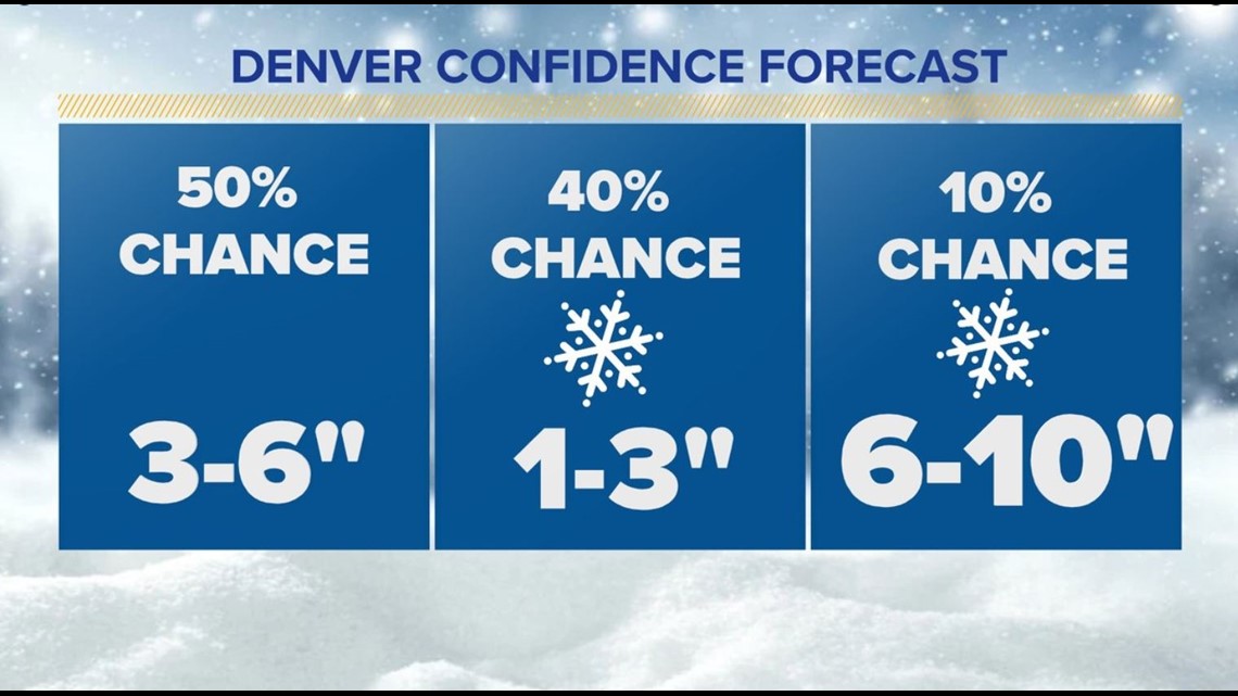
In the Denver area, the heaviest of the snow will probably fall on Tuesday night and Wednesday morning before gradually diminishing throughout the rest of the day. Most of the Denver area will most likely end up with 3-6 inches worth of snowfall, though it appears most areas will probably see closer to the lower end of that range.
Here's the rest of what we know right now.
Timing
Two storm systems will phase together (combine) on Tuesday, setting up one big powerful storm that'll track through the Four Corners and nudge its way in our direction by Tuesday night.
The storm looks a bit more ragged than it did on computer modeling last week, and that may lead to slightly weaker impacts as a result. That said, we're still looking at a decent snowstorm for much of the state.
The snow will move in from southwest to northeast on Tuesday. A cold front pushes through the Denver area on Tuesday evening, helping kick off the snow between 6-10 p.m. on Tuesday night.
The heaviest snow for the Denver area likely falls late on Tuesday night and early Wednesday morning. By dawn on Wednesday, the heaviest snow will probably be done.
If you've got dinner plans on Tuesday night for Valentine's Day, watch out for slick roads, especially by the time you get out of dinner.
Impacts
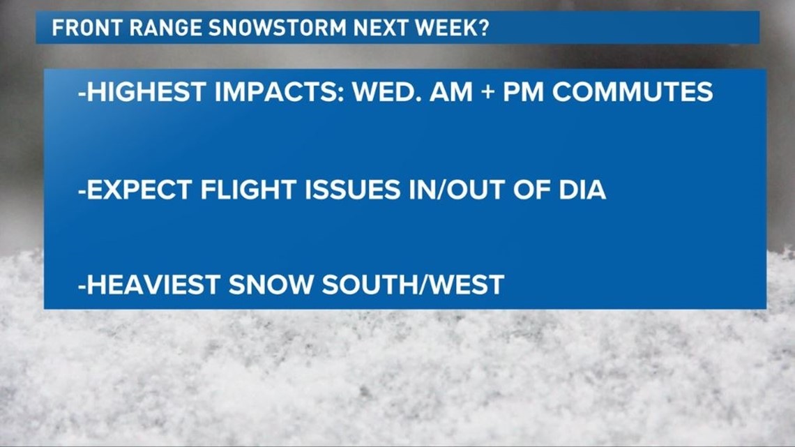
While the majority of the snow probably falls overnight Tuesday into Wednesday, we're still anticipating a slick morning commute on Wednesday with falling snow and some gusty winds in the Denver area. Wednesday morning's commute will probably be the most impacted by this particular storm.

Some lingering impacts probably continue into Wednesday evening. Based on the current look of the storm, it looks like we may end up seeing more school delays than closures in the Denver area, though some schools in higher-impacted spots like the Palmer Divide and the foothills could end up being closed on Wednesday.
Denver International Airport will probably see some delays and perhaps some cancellations late on Tuesday night and especially on Wednesday morning. A combination of gusty winds and falling and blowing snow will reduce visibility, making it difficult for flights to get in or out on Wednesday.
If you have the option to move your flight from Wednesday to Tuesday or Thursday, you'll probably be able to avoid delays or even cancellations.
Impacts will be higher in southern and eastern Colorado, where heavier snow and more wind will make travel especially difficult. Areas from Highway 50 on south will likely see the worst impacts, and La Veta Pass in particular may be next to impossible to travel on Wednesday.
The snow will gradually diminish from west-to-east during the day on Wednesday.
Totals
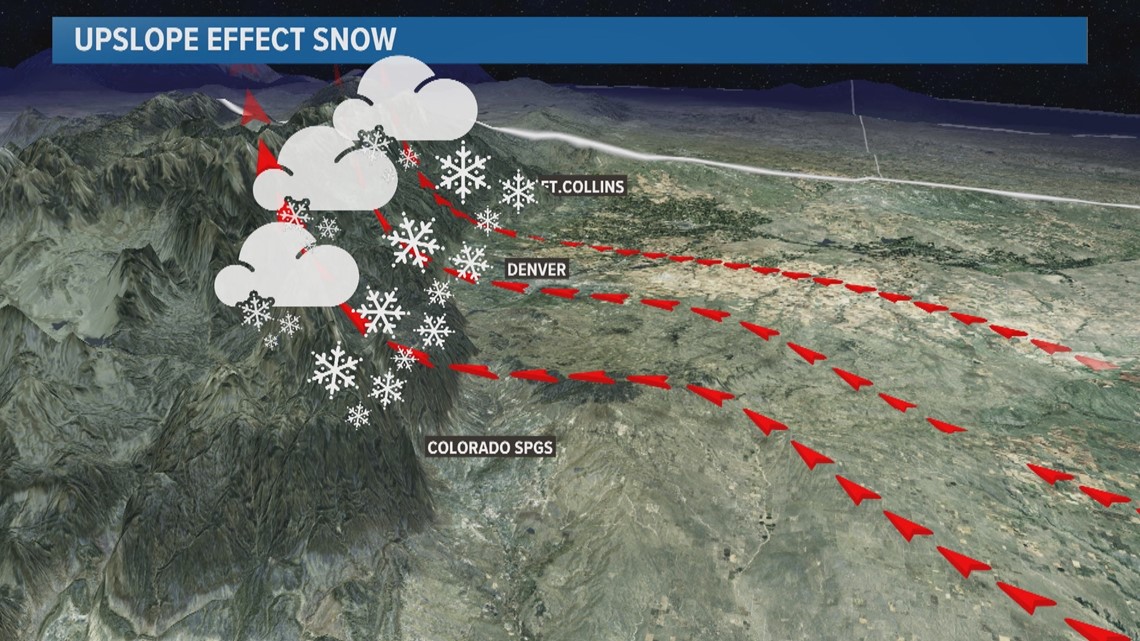
Snowfall totals will vary widely, as they tend to, from one side of the Denver area to the other. The Palmer Divide, and the southern and western foothills (south of I-70) will probably wind up with the highest totals, and a few eight- or nine-inch amounts seem plausible in these areas (especially above 6,000 feet in elevation).
Meanwhile on the north and east sides of the metro area, less than three inches of snow might fall.

Upslope flow will favor the foothills and higher elevation locations, so in general, the further north and east you go from the mountains, the less snow you'll probably see.

Talk nerdy to me
There's still a lot of uncertainty around our Valentine's Day storm, and for those of you so inclined, let's get into the nitty gritty of this. The heaviest snow probably stays over southeastern Colorado from this storm, though it wouldn't take too far of a jog north for our storm system to bring bigger impacts to the Denver area.
As we mentioned earlier, this storm doesn't look as robust as it did in computer modeling just last week and over the weekend. It shears apart too early, meaning it probably won't pack the full punch that it appeared it might.
It's also going to move relatively quickly, making a bigger storm less likely.
But, a good thumping of snow looks likely along the cold front as it first pushes through the metro area overnight Tuesday into Wednesday morning. That's when the heaviest snow probably can and will fall.
Also, relatively high snow-to-liquid ratios (the amount of snow that falls from the same amount of liquid varies, depending on temperature) mean that even just a quarter-inch of precipitation would probably produce four or five inches of snow in the Denver area, and perhaps even more than that.
We'll keep you posted with any forecast adjustments as the storm gets closer. Stay tuned to 9NEWS and 9NEWS Weather for the latest.
SUGGESTED VIDEOS: Latest from 9NEWS