
COLORADO, USA — This blog will be updated once a day as we watch the potential for a weekend snowstorm roll in.
Saturday Update:
Dec. 15
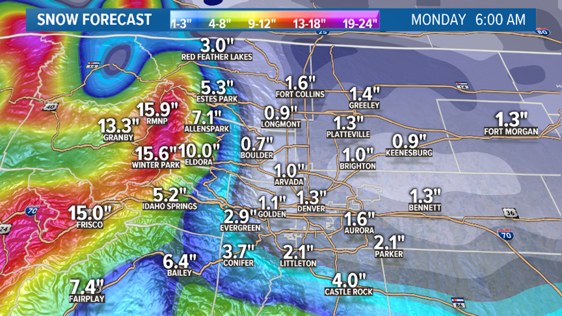
The first three days of this storm systems produced amazing snow totals in the central and northern mountains with close to 40 inches being reported. The final leg of this storm will shift its focus to southern Colorado, and will be almost a complete miss for Denver and the rest of northeastern Colorado.
The storm is just moving ashore over northern California tonight and won't even arrive to the Front Range probably until the afternoon hours.

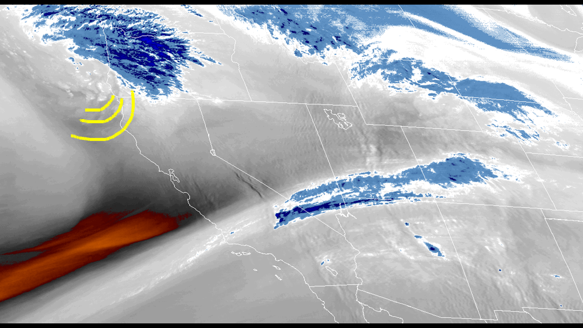
The storm was seen on satellite water vapor imagery as weak and likely taking a more southern trajectory than models were showing yesterday. If you live north of I-70 you might want to go outside an see how much snow you got today, because that will likely be your storm total when this is all over.
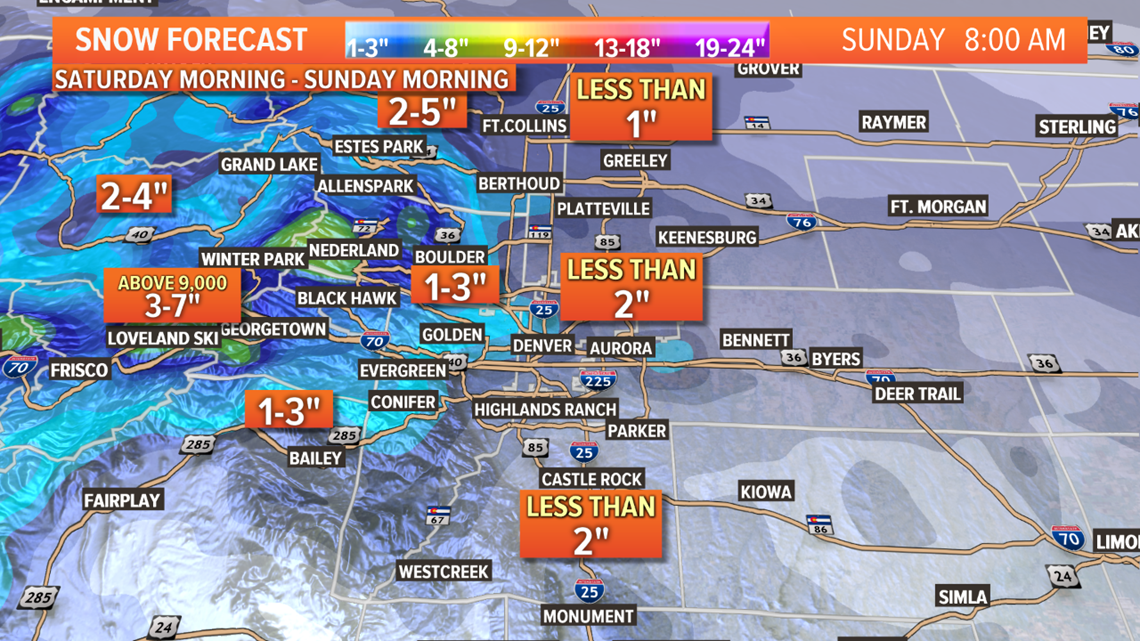
In the Denver metro area, the snow might not arrive until afternoon hours. There should be some snow north of I-70 but it will likely result in less than an inch. It probably won't reach too far north of the Denver metro.
Areas of the metro that are south of I-70 may be able to stay on the outer edge of the storm system and pick up a couple inches. Snow should start a little earlier there too.
Even the light snow will be able to easily stick to the ground and streets.
The Palmer Divide should be able to get mostly 1-3" with a few spots with maybe 4".

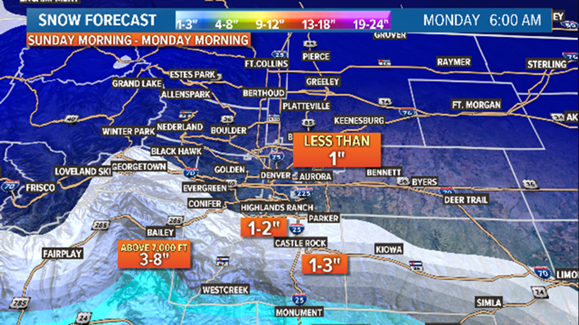
The Colorado Springs area has a Winter Weather Advisory for 3-6" which is still possible, but probably end up closer to the lower end of that spread. Maybe the Cheyenne Mountain or Manitou area could get closer to 6".
Even Teller County may be too far north to get close to 6", still possible but likely lower there as well.
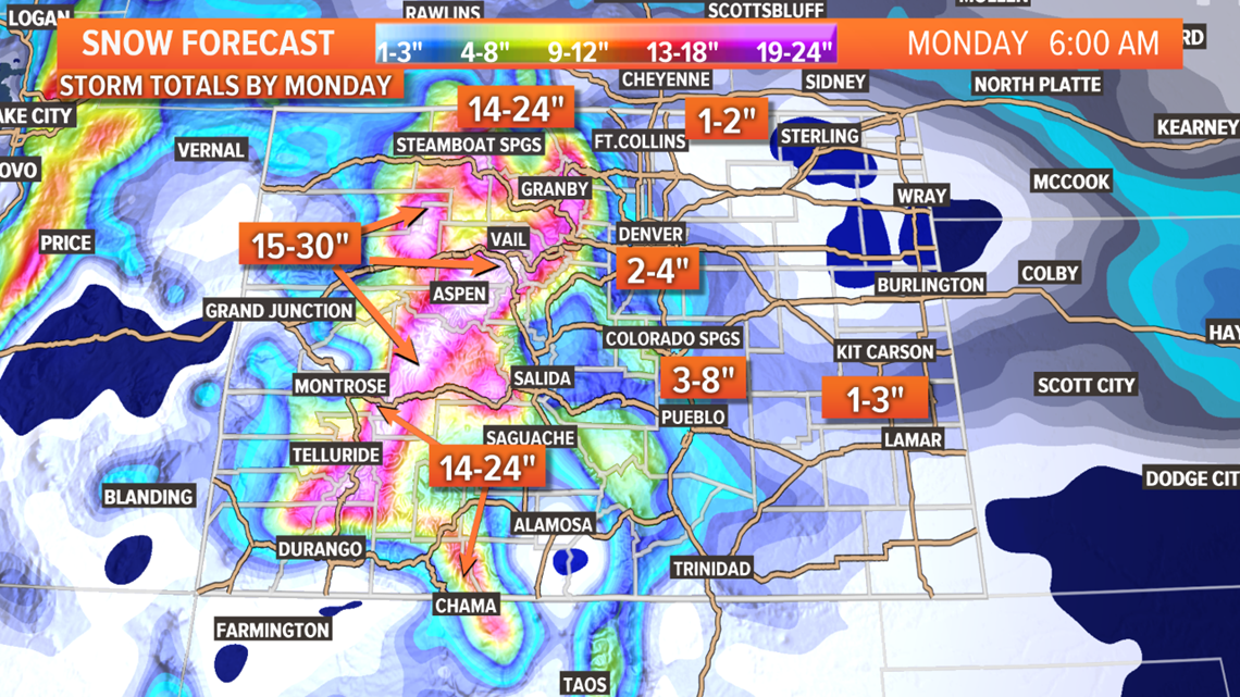
There area's that could still end up getting 6-10" are the Wet Mountains and the Sangres which the models have been focusing on all along. Winter Storm Warnings are in place there.
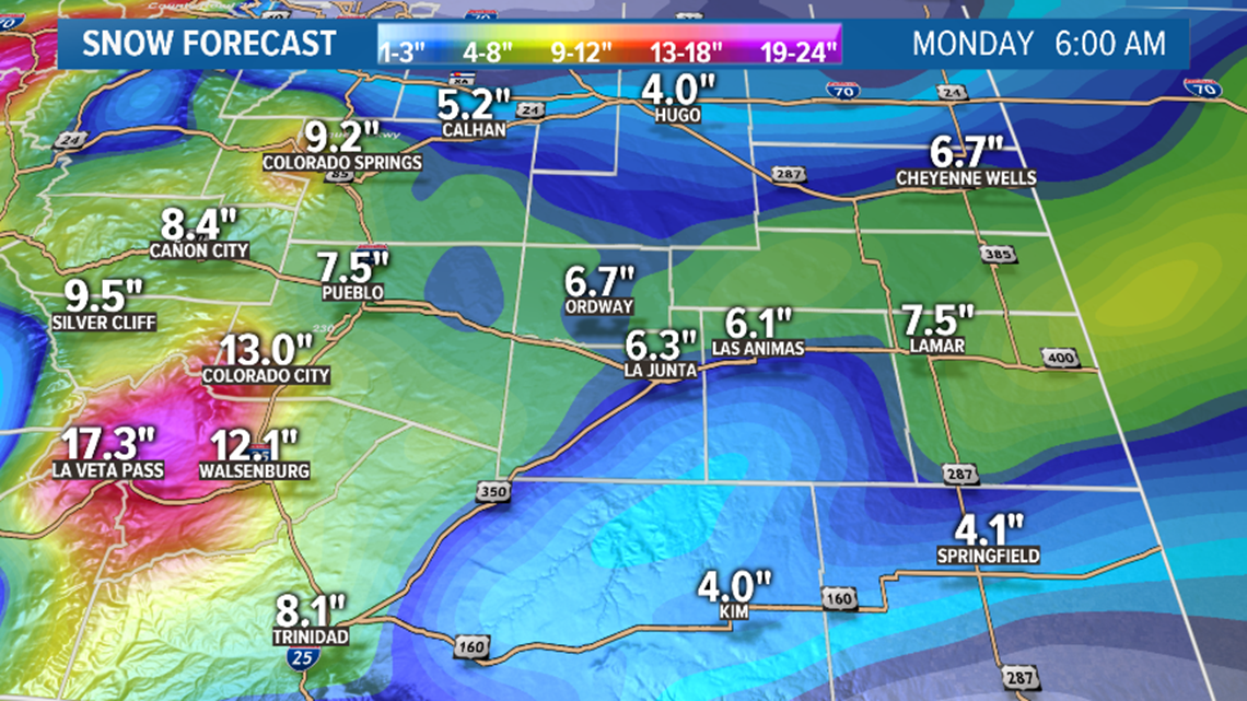
Southeast plains will still get the snow. Pueblo and Las Animas Counties are in the 3-6" which is still possible. East of there will probably be in the 1-3" range.
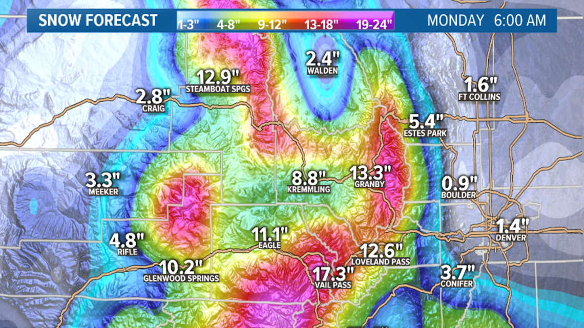
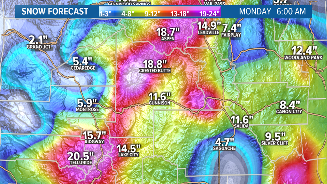
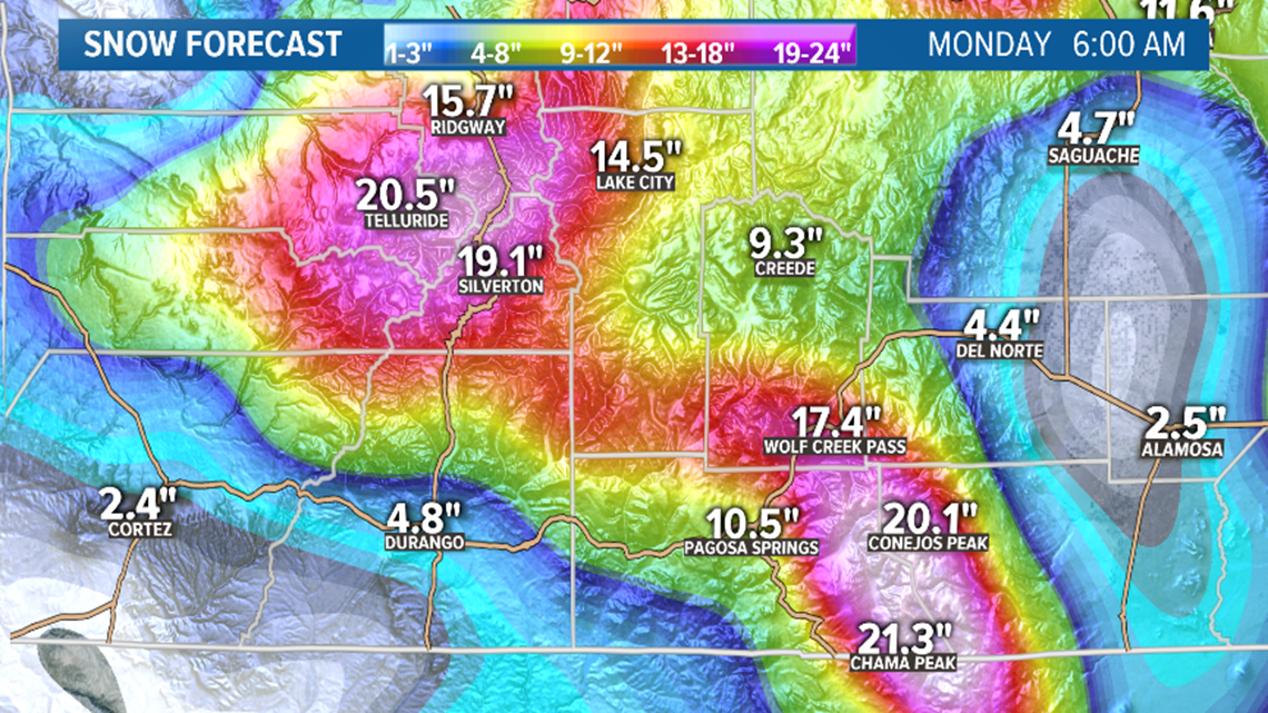
The San Juans will get most of their snow overnight and into the morning. Spots like Wolf Creek Pass could still get a foot of fresh powder.
Because of the late arrival, snow will continue down south into Monday. Probably lightening up around noon, but some snow bands will be possible on the I-25 south corridor and the southeastern plains for most of the day Monday.
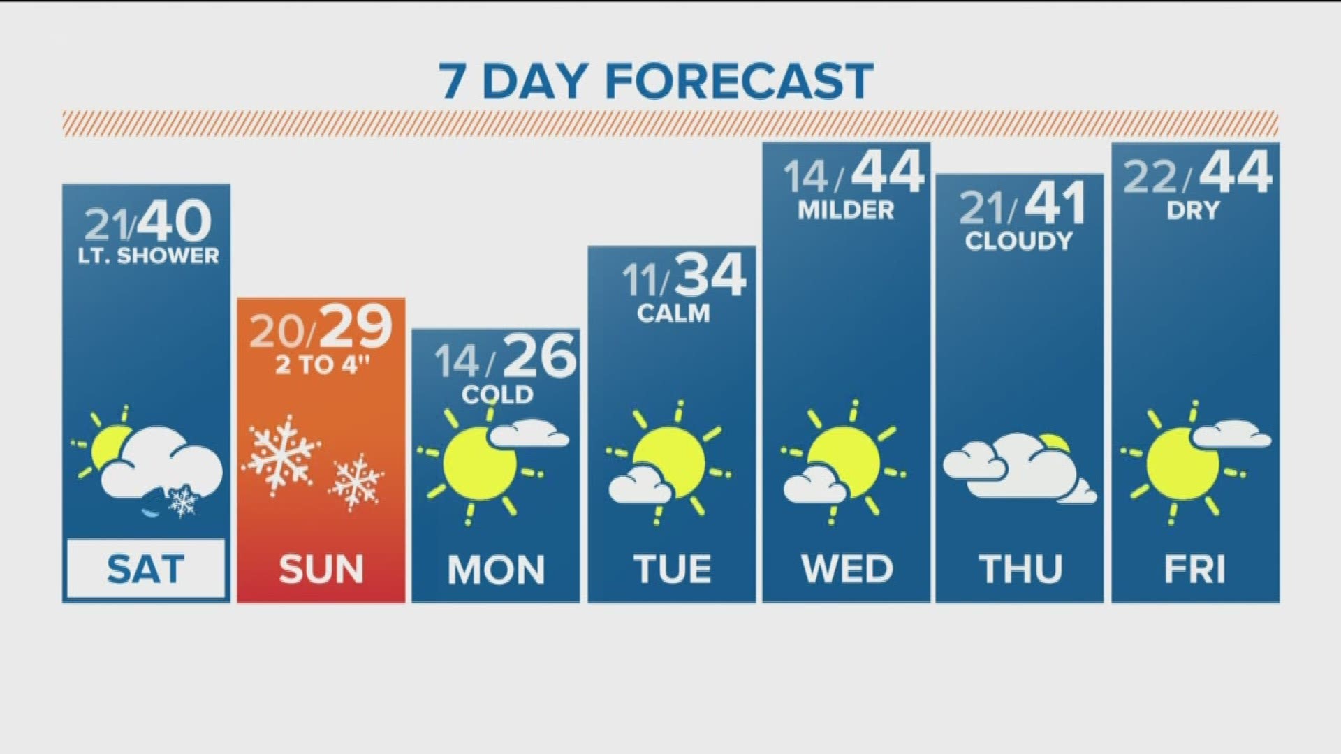
Chance of snow in Denver: 40%
Dec. 19-20
This storm system is still showing up in the modeling as a fast moving and weak storm that brings light snow to the mountains. 1-3" of snow to the high mountain passes.
Chance of snow in Denver: 0%
Dec. 23-27
The GFS has been consistently showing a strong trough diving south along the Pacific coast with some impacts to the Colorado mountains on the way down, and possible coming into prime upslope position by Christmas.
Three out of its last four model runs has shown snow in Denver on Christmas night into Thursday morning Dec 26.
This is not quite in range of the high resolution Euro yet so it will be interesting to see if there is any early agreement. This storm would impact travel for those who have to leave right after Christmas.
Chance of snow in Denver: 0%
Dec. 28-30
No storm action is shown in Colorado for this timeframe at the moment.
-----
Friday Update:
Dec. 14-15
First round was great, and just like Thursday the snow is expected to intensify overnight. Snow will come down to the plains in a few areas tomorrow, but Sunday will have more widespread snow chances.
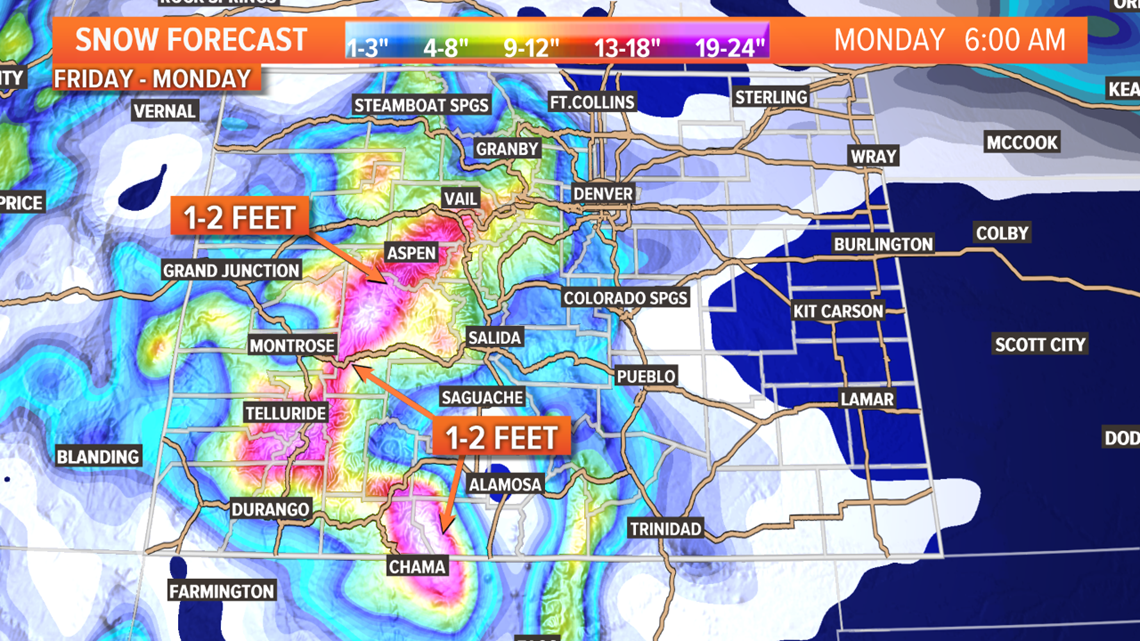
Saturday: The mountains of southwest Colorado have now joined in with a Winter Storm Warning that goes into effect at 11pm tonight. Snow should stay pretty heavy until Monday morning at about sunrise. Still looking at storm totals of 2-3 feet.
The Denver metro could see a wave of snow showers move through sometime between late morning and evening. Could be briefly heavy but won’t last long enough to get much accumulation. Maybe just an inch at best. Most of the day will feature just a cold breeze and some mix of clouds and sunshine.
Should not be any impact to the roads with these snow squalls on Saturday.
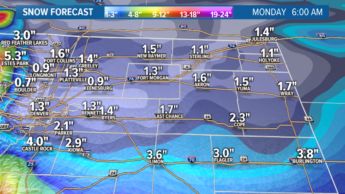
Areas to the north of Denver could also see some snow bands. Probably a little earlier there. Places like Weld, Boulder, and Larimer counties could get an about an inch of snow out of those.
A few of these snow bands will likely hit the northeast plains as well, but probably less than an inch of snow.
Spots in the upper foothills like Blackhawk, Nederland, and Ward could get some more steady snow. Snow totals have been trending down a bit here, but could still get about 5-6 inches. Mountains towns like Vail, Frisco, Silverthorne, and Breckenridge got quite a nice hit Thursday into Friday night, and could get an additional 4-8 inches by midnight Saturday.
Snow is less likely to the south in places like the Palmer Divide, the Pikes Peak Region, and the southeast plains, but some of these bands should be able to make it down that way. I could see some spots getting a half inch or an inch. Until late Saturday night but that will more likely be the very beginning of the Sunday event.
Sunday- Snow continues in the high country with the heaviest snow focused in the central and southern mountains. Some spots could reach 2-3 feet storm total by midnight.
Most of the impacts should be south of Interstate 70. The Winter Storm Watch in southern Colorado has still not been switched to warnings or advisories. That should be coming soo. Parts of Teller, El Paso, Pueblo, and Fremont Counties could still be looking at 3-6”. Recent modeling has been trending down just a tad, but not enough to change that spread yet.
In the Denver metro area, the snow should hit just after midnight and last for the whole day. With temps in the middle 20’s, the snow will be able to stick to the roads.
We’ve been sticking with a range of 2-4 inches for almost all of the Denver metro and I still like these numbers. The GFS and the NAM support this.
The Euro however has a much different solution. It has the snow starting later, ending early, and much lighter in nature, with a spread of 1-3 inches in the metro. With a lot of those places below 2”. A lot of your phone apps like Wunderground which gives a lot of weight to the Euro may be reflecting these low numbers. Preparing for 1-3, is not much different to preparing for a 2-4. Probably would not require a Winter Weather Advisory either way, but just keep in mind that the roads could get icy with those low temps.

Less snow to the north, northeast, and east of Denver but could get another inch or so there.
The Palmer Divide has been trending up to the 3-6" range, but still no indication of any advisories there yet either.
The I-25 corridor between Monument and Colorado City should be a little more interesting. Colorado Springs could fall within the 3-6" range. I wouldn't be surprised to see a Winter Storm Warning issued there, but they will at least get an advisory.
Both the GFS and the Euro are still showing big numbers in the Wet Mountains, and the Sangres where a few spots could hit 10 inches. They are still in a Watch at the moment, but this area should get a warning soon.
On the southeast plains, there will likely be a decent snow band through that region. Could be anywhere south of I-70 down to the state line, but models have frequently been showing it along the Highway 50 corridor from Pueblo on into Kansas. Mostly 2-4" inches in that band with a little more in a few spots. The GFS shows this band quite a bit smaller though. It may not be until early Monday morning for the snow to stop down there.
Chance of snow in Denver: 90%
Dec. 19-20
A light mountains storm looks to bring 1-3" of snow to the high country, with only a slight chance of some flurries in the metro areas.
Chance of snow in Denver: 0%
Dec. 23-27
The GFS seems to think we are flirting with Christmas Greatness in this timeframe. It shows a significant snowstorm on the eastern plains on about every 1 out of 5 or 6 model runs.
It has been very consistent in showing a strong south diving trough that cuts of and swings very near to southern Colorado. The placement of that low is different every time though. This one will be really fun to watch, not only because of it’s potential, but also due to the timing around the holiday.
Chance of snow in Denver: 0%
Dec. 28-29
Currently showing a storm in the Colorado area, but not close enough for impact.
-----
Thursday Update:
Dec. 13-15
Snow is picking up intensity Thursday night in just the first day of a four-day storm. There is actually a separate system on Saturday and Sunday that will bring the snow down to the plains.
Friday: The bulk of the snow will be in the central and northern mountains where there are Winter Storm Warnings already in place.
There won't be too much action down in the Denver metro area although there is a storm system over us, so some snow showers might be able to make it down. The most likely spot for this will be the west and northeast metro. No impact from these though, as they will be short-lived. The downsloping winds that will help prevent snow showers from lasting will also get the air temperatures up into the 40's and bring a few strong wind gusts at times.
A few quick snow showers will be possible on and around the Palmer Divide as well.
Saturday: Snow showers will be heavier and more widespread in the mountains. The heavier stuff will make it down to southwest Colorado too. A Winter Storm Watch is in place at the moment that could soon become a warning.

The Denver metro area has a better chance of getting hit by one of those fast-moving snow bands -- probably nothing too steady though. It would probably take getting hit with more than one band to get much more than a half inch of accumulation.
Areas to the north of Denver have a better chance of getting a long lasting snow band. Places like Weld, Boulder, and Larimer counties could get an inch or two if this happens.
A few of these snow bands will likely hit the northeast plains as well, so an inch or two of snow will be possible in select locations.
Spots in the upper foothills like Blackhawk, Nederland, and Ward could have 8-10" of accumulation by midnight. Mountains towns like Vail, Frisco, Silverthorne, and Breckenridge could have more than a foot at this time.
Snow is less likely to the south in places like the Palmer Divide, the Pikes Peak Region, and the southeast plains, but some of these bands should be able to make it down that way. I could see some spots getting a half inch or an inch.
Sunday- Snow continues in the high country with the heaviest snow focused in the central and southern mountains. Some spots could reach 2-3 feet storm total by midnight.


More of an impact to the Eastern Plains is possible on this day but there is quite a difference in where this storm system may end up tracking. So another day of modeling will be needed. There is a higher chance of most of the impacts being south of Interstate 70 though. If fact there is a Winter Storm Watch for some counties in southern Colorado including Teller, and El Paso. That will switch to either a warning or an advisory depending on where the storm ends up coming through.
In the Denver metro area the snow should set in steady just after midnight or even a little before on Saturday night, but I would expect snow during most of the day. Not anticipation an advisory here but it is still possible. The GFS is still indicating the possibility of 2-5 " widespread in the metro, while the Euro has 1-4" with mostly 2's. The GFS is showing all that snow coming before noon, so that would probably require an advisory.
Less snow to the north, northeast, and east of Denver but could get another inch or so there.
The Palmer Divide could end up between 1-4" but no advisories indicated there yet.
The I-25 corridor between Monument and Colorado City should be a little more interesting. Colorado Springs has been trending up again in today's modeling. Roughly 3-6" seems very doable there. With most of that coming in a short amount of time on Sunday, I wouldn't be surprised to see a Winter Storm Warning issued there, but they will at least get an advisory.
The bulls eye of Sundays event continues to be the Wet Mountains, and the Sangres where a few spots could hit 10 inches. They are still in a Watch at the moment.

Another interesting spot is the southeast plains. There will likely be a decent snow band through that region. Could be anywhere south of I-70 down to the state line, but models have frequently been showing it along the Highway 50 corridor from Pueblo on into Kansas. Mostly 2-4" inches in that band with a little more in a few spots.
Chance of snow in Denver: 85%
Dec. 19-20
A light mountains storm looks to bring 1-3" of snow to the high country, with only a slight chance of some flurries in the metro areas.
Chance of snow in Denver: 0%
Dec. 21-22
This system has not shown up in the last two days of modeling and is likely dead.
Dec. 23-26
This has been shown as a big southern diving storm. In recent modeling it shows some impacts to Colorado on the way down and on the way out as well. This would mean places in Colorado are likely to get a White Christmas.
On the latest GFS it shows snow in the Denver metro on Christmas eve night into Christmas morning. The run before that showed a significant amount of snow, and the run before that showed none. So obviously not a strong signal, but it is gaining some momentum as of late.
Chance of snow in Denver: 0%
Dec. 27-28
Currently showing a storm in the Colorado area, but not close enough for impact.
----
Wednesday Update:
Dec. 12-15
There are essentially two storm systems headed our way. The main impact will be in the mountains as the flow from the Pacific Ocean sets up a river of upper level moisture. The mountain peaks will intercept that moisture, but there will also be a few upslope opportunities on the eastern side of the mountains as well.
The first part of the storm on Thursday and Friday, looks like it will stay in the mountains. Snow showers begin on Thursday morning in the northern mountains and gradually spread south.
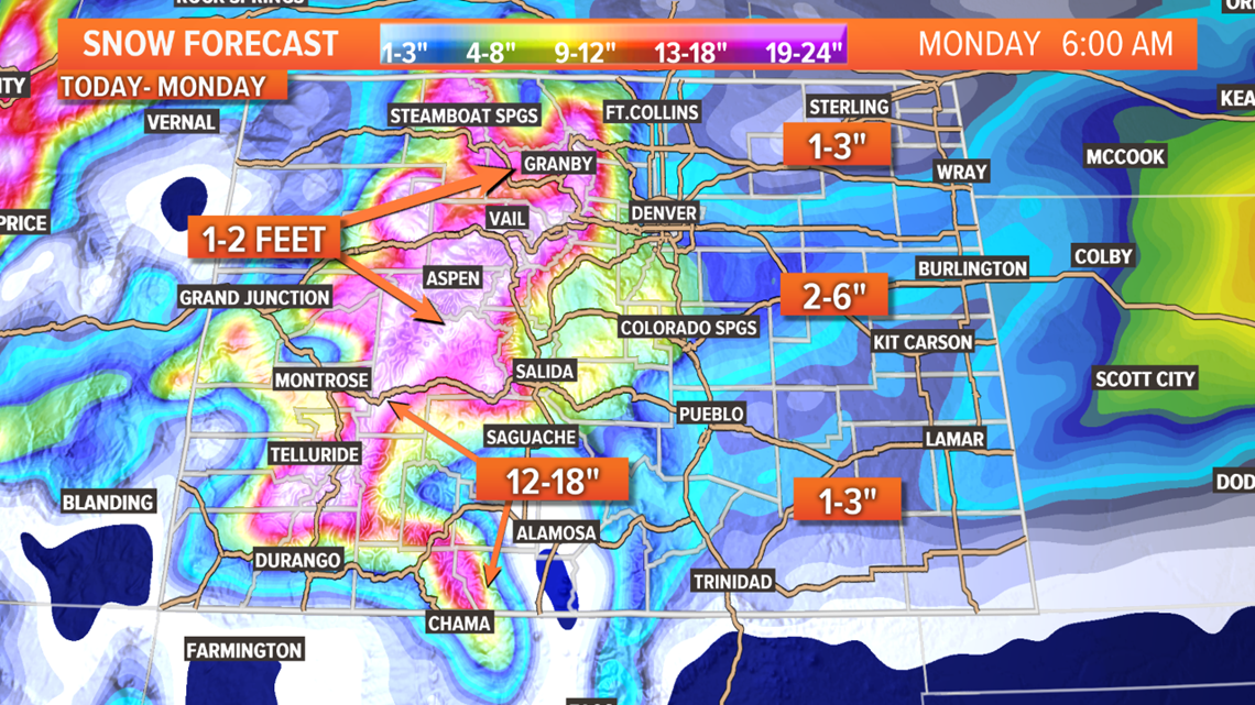
Still looks like Friday and Saturday will likely have the heaviest waves of snow. 12-18 inches of snow could fall in areas above 9,000ft by Sunday morning.

At the lower elevations, it may feel like a few different waves of storms. There may even be a few surges of small cells that overcome the downsloping flow off the mountains as early as Thursday or Friday, but those will be short-lived and pretty dry overall.
The main impacts will come on Saturday and Sunday. The Euro like Saturday and the GFS likes Sunday. It is quite possible that we get a little snow both days.
It is possible that we get just enough snow in the Denver metro, and the Colorado Springs metro to get a Winter Weather Advisory, as both areas are showing between 1-4"

The foothills are split in the modeling. The GFS has mostly the southern foothills from Teller County to Costilla County with 3-6", but the Euro also brings the foothills north of I-70 into play with a little more snow.
The plains to the east of I-25 will also get some snow, although the trend as bend downward. As of now I wouldn't expect to see any advisories out there. The southeastern plains might have a chance at some banding that could get some spots over 3 inches, but at the moment that doesn't seem too widespread.
Chance of snow in Denver: 55%
Dec. 19-20
The storm in this window is showing up as mostly a weak mountain storm with 1-4" possible in some areas. It has been showing just enough snow in the Denver metro late Thursday night (Dec19), into Friday morning (Dec20) to get some accumulation, but so far it is indicating less than an inch.
Chance of snow in Denver: 0%
Dec. 21-22
This storm has lost it's signal in recent modeling.
Chance of snow in Denver: 0%
Dec. 23-24
A little bit of momentum with a small storm that could bring a little snow to Denver on Christmas Eve. So far models are showing light snow in the mountains, and a dusting along I-25.
Dec. 25-27
The GFS has been hinting at a large ridge building sometime around Christmas. This would deliver some warm temperatures. Maybe even up to 60 degrees. This will probably ensure that December finishes well above average on temperature, as places like Denver are already running 3.5 degrees warmer than usual 11 days into the month. Not record breaking territory, but unusually warm.
----
Tuesday Update:
Dec. 11
A very fast-moving and weak storm system will move through Colorado tomorrow. Just light snow expected in some of the mountains with no precipitation on the plains.
It is possible there will be no accumulation with this, but a couple of the mountain passes could pick up an inch or two. No advisories with this storm
Chance of snow in Denver: 0%
Dec. 12-15
A couple separate bends in the jet stream will impact Colorado starting Thursday evening. In the Denver area, it will probably feel like a few different waves of storms during this time, with the most impact on Sunday.

Snow should startup in the mountains before 5pm on Thursday. I would expect some Winter Storm Watches to go up sometime Wednesday as advisories and warnings will probably be needed in the mountains for this 4-day snow event. 12-18 inches of snow could fall be Monday morning.

Travel on the mountain passes could be difficult at many times over the weekend, as heavy waves of snow should hit from north to south.

Snowpack is holding above average statewide, and the coverage of this snow will keep all zones up. These are all 4-day totals from the GFS.

On the plains, the bulk of the snow appears to be focused south of I-70, with the most in the southern foothills from Teller Country to Costilla County.

For the Denver area, Palmer Divide, and northern foothills, the chances for major snow impacts are much lower. Models are showing mostly between 1-2 inches of snow accumulation for most spots there.
The first chance at snow will probably come on Saturday morning. So far it doesn't look to heavy with no accumulation in Denver but maybe a dusting to the west and south.
Then, on Sunday, the snow is more likely to stick. It will even be cold enough to stick to the roads if we get enough. The chances of that are just low at the moment. Two inches over a whole day usually doesn't amount to any impact to people.

The northeast plains will also see low impacts from this snow.
Chance of snow in Denver: 40%
Dec. 19-20
This weak and mostly mountain storm is still showing up in the modeling. None of the recent runs have shown it getting any closer to having a big impact on Colorado. The timing has changed several times, but is keeping centered around Dec 19.
Chance of snow in Denver: 0%
Dec. 21-22
The storm in this window is still showing as a weak storm with mostly only mountain impacts.
Chance of snow in Denver: 0%
Dec. 23-26
The solution from the GFS has changed for this window. It has switched the ridge to the east and the trough to the west. That is normal this far out. This is the storm that we will be watching for a White Christmas somewhere. The Euro weeklies has been showing more to the west, and now the GFS is showing the better chances to the west as well.
----
Dec. 10-11
There are still some mountain showers going overnight Monday into Tuesday, and even a quick shot of snow possible in the northeast corner on Tuesday morning, but no impact to anyone with those.

A quick and weak storm system will roll through the Colorado high country on Wednesday. There will be no impact to the Denver metro area, but some mountain passes could get a couple of inches out of it.
No advisories are anticipated.
Chance of snow in Denver: 0%
Dec. 12-15
A pair of storm systems appear likely in this window, with some impact to the Denver area possible on Saturday or Sunday.
The GFS has stepped up its timetable on these storms to match closer to what the Euro model has been showing.
They show a mostly mountain storm to start with on Thursday night and through the day on Friday. By Saturday afternoon, the storm may try to move down into the metro areas along Interstate 25.
The models are only showing snow accumulation on 2 of the last 4 runs though, and when they did show snow, it was only in the 1- to 4-inch range.
What I take out of the recent modeling is a weak signal due to inconsistency with timing, and low snow totals on the Front Range. It has been just consistent enough though to mean the odds are good for some wintery impacts on the Front Range this weekend.
Chance of snow in Denver: 10%
Dec. 18-19
The GFS has been showing a weak southern storm track here, but with some impact to the Denver area. So far it's only showing less than an inch of snow -- not really a big storm for the mountains either.
Chance of snow in Denver: 0%
Dec. 21-22
Another quick and weak signal here, mostly some light mountain impacts shown so far.
Chance of snow in Denver: 0%
Dec. 23-25
The modeling is not showing a lot of love right now in support of a white Christmas. In fact, they show the complete opposite. The GFS is hinting at our first strong ridge of high pressure since early November. If this solution plays out, we could be looking at 60-degree temperatures on Christmas Day. This is the first run the Holiday has been in range of the GFS though, so really really early.
SUGGESTED VIDEOS | Science is cool