DENVER — Parts of the Denver area picked up as much as eight inches of snow on Tuesday morning, and while Blizzard Warnings were up for some, this morning's snow came as quite the surprise for most.
So what caused Tuesday morning's surprise snowstorm? Let's start by looking at the basics.
A highly localized snow band spanning about 20-25 miles led to some ridiculously heavy snow before dawn on Tuesday morning. It's quite likely that 2-3 inches of snow fell in a single hour in parts of Aurora, Centennial, and Englewood, perhaps even in south Denver.
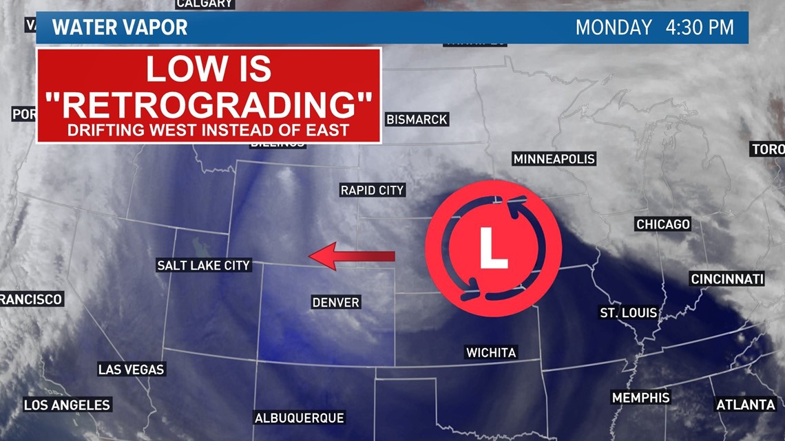
This came from a rare "retrograding" area of low pressure that slowly spun from east-to-west on Monday over central Nebraska. A retrograding low means it's moving in a direction against the climatological normal. Simply put, the low was moving in a weird direction.
Due in part to the fact that this is a relatively rare direction for lows to travel (our weather almost always moves in a west-to-east direction), computer forecast models didn't show the low moving quite as far west as it ended up going. That meant the low was just close enough to bring us stronger winds and more instability than forecast. Based on surface observations on Tuesday morning, it looked like the low was about 50-100 miles further west than most computer forecast models showed. And that seems to have made all the difference.

The closer low brought in stronger winds and colder temperatures from the north, helping create instability. Instability is a term we often use more in the summer months for severe weather setups, but in this case, we had both temperature and wind variation with height.
The instability can help the air rapidly rise and create heavy precipitation in localized areas.
Finally, it appeared that the strong winds may have created a localize "barrier jet". When the wind is forced against mountain terrain, it can create a localized perpendicular wind to the mountain terrain. When north winds (with perhaps a slight northeasterly tilt to them) backed against the southern foothills and the Palmer Divide, it could well have helped create an extra boundary that forced the air to rapidly rise and condense into the snow band that we saw this morning.
Snow rates may have been as high as 2-3 inches per hour within Tuesday morning's band in a few locations, and it was likely caused by a combination of highly localized factors like instability and a barrier jet. And all of that likely was helped by the main area of low pressure spinning further west than anticipated.
But not everyone saw the snow. Areas along and north of I-70 saw little or no snow from Tuesday's snow band, and that goes to show just how challenging forecasting in a place like Denver can be. Thirty miles made the difference between zero and eight inches of snow.
There are likely a few other factors that played in as well, but hopefully, this helps show why we saw such a surprisingly big snow in parts of the Denver area on Tuesday morning.
SUGGESTED VIDEOS: Colorado Climate