

COLORADO, USA — With the first one out of the way, there may be a little less interest in the next few winter storms, unless they are forecast to be big. Which is not out of the question.
RELATED: BLOG | First Snow Watch 2019
I like to watch computer modeling, so follow along if you like. I will update this blog every afternoon until the next storm, and then create a new blog entry.
TUESDAY OCT. 22 UPDATE:
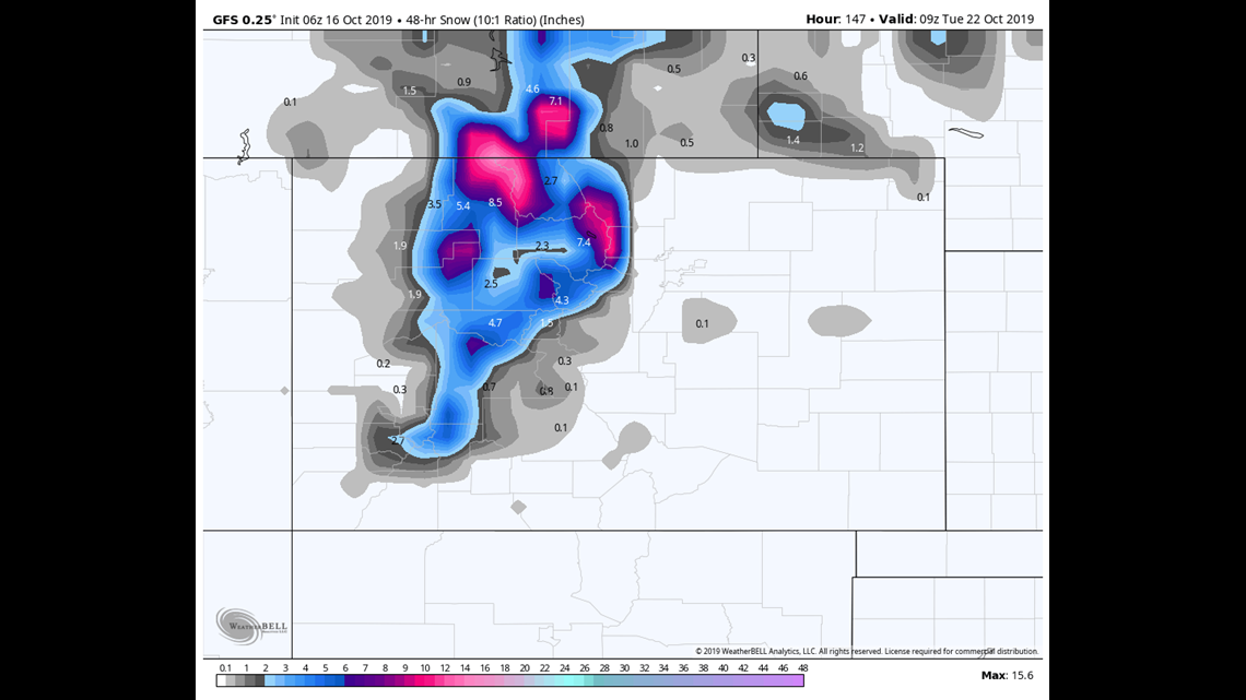
October 23-24
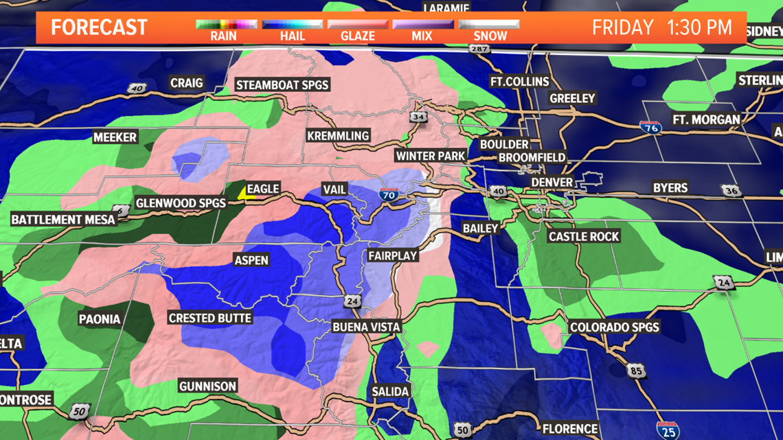
Looks like this will be the last entry in this feed as there is an extremely high probability of Denver getting measurable snow tomorrow. There is still a slight bust potential, but not a single model shows a total shutout. There is a higher chance of it busting over forecast than under.
The models unanimously show the storm front arriving by about 2 or 3 pm Wednesday, with snow starting in the metro shortly thereafter. There is a favorable setup for large snowflake growth which should lead to some very heavy snowfall rates. The bulk of the impact in the Denver area should be between 5pm and midnight. The evening commute around town will likely be difficult and slow.
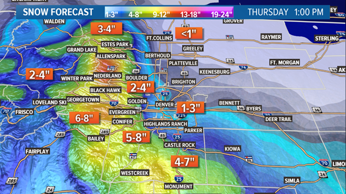
This is an upslope storm. That means not too much precipitation west of the Continental Divide. It also means a large snowfall spread. Modeling is in good agreement of a 1-5 inch spread in the metro with the 1's to the east like Bennett, DIA, and the 5's to the west in places like Boulder, Golden, and Ken Caryl.
Only the Euro shows the snow lasting until through the morning drive on Thursday. There is a good chance the bulk of the snowfall will be over by 5am in Denver. There are no advisories out for Denver at this time, but the National Weather Service does have the option of issuing one of the new Snow Squall Warnings for short term bursts of heavy blinding snow if that situation should arise on Wednesday night.

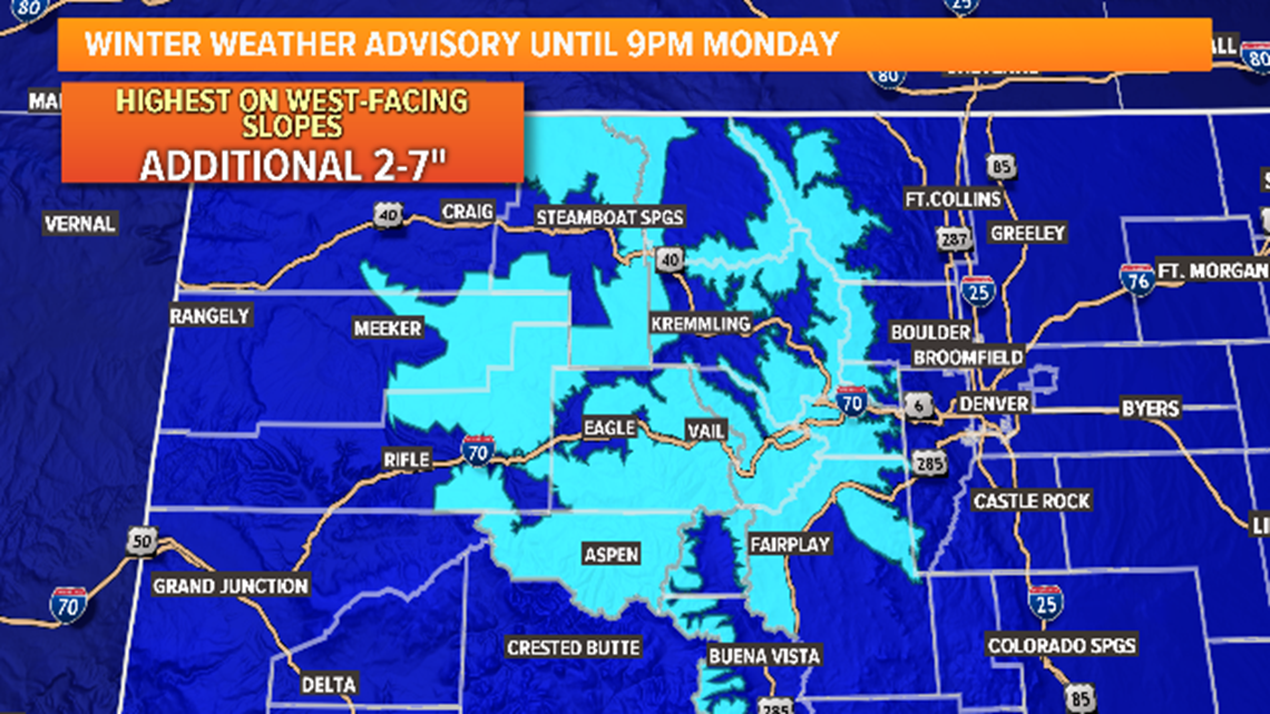
The bullseyes for this storm are the south Jefferson, Douglas, El Paso, and Teller County foothills, with 6-12 inches possible there. A Winter Storm Watch is in place which could turn to a Warning, or an Advisory this evening.
The Palmer Divide is also included in the Winter Storm Watch. With 4-8 inches possible along I-25 from Castle Pines to the Air Force Academy. Much better chance for the storm lasting through the morning commute on Thursday in these areas.
Chance of snow in Denver = 90%
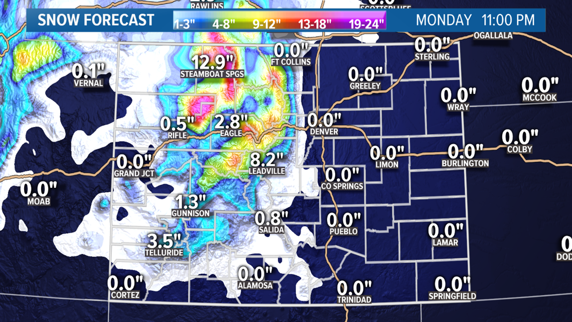
October 27-30
The next storm is becoming more clear, and also will have a high chance of snow in Denver, although it doesn't look very big either. There is some disagreement still on duration. This will likely be separated into two separate storms.
The GFS shows a 1-3 inch snow storm in Denver on Sunday, and not much impact from a system on the 29-30 of October. It's solution has snow just after sunrise Sunday and lasting through most of the day.
The Euro also has a similar timing and intensity of Sunday's storm, but also shows snow in the Denver metro with a system a couple days later on the 29th and 30th.
Chance of snow in Denver = 15%
Modeling still shows Halloween as cool and breezy. No snow on the day, but if there is snow on the 29th, there could still be some on the ground.
MONDAY OCT. 21 UPDATE:
October 21
A storm system has just about moved out of Colorado, but more mountain snow and even scattered snow showers at the lower elevations are possible today. The storm is well off to the east, but the jet stream is still situated directly above Colorado.
This will lead to one last wave of mountain snow showers. There is a Winter Weather Advisory in place until 9pm for an additional 2-7 inches.
A strong jet still overhead will lead to banded showers despite the downsloping northwest winds. They should be widely scattered and brief, but there is a chance none the less. Mesoscale models show a few bands in the Denver metro this afternoon and evening, and also out near the eastern part of the Palmer Divide near Limon. These might not be strong enough to lead to actual snow accumulation however.
Chance of snow in Denver = 5%
October 23-24
The next storm will bring a higher chance of snow in Denver. It will be moving into Colorado on Wednesday and lasting into Thursday.
This mornings run of the GFS shows the bulk of the snow hitting between 6pm and midnight on Wednesday, but lingering into Thursday morning as well. Most of the GFS members show between 1-3 inches of snow in the Denver area with the higher amounts in the west and south metro.
Last nights Euro also shows a similar scenario, but with it a little longer lasting into Thursday afternoon.
Some of the foothills are shown in the 3-6 inch range, while mountain areas could get up to 10 inches.
This snow brings a higher chance of snow in the metro and foothills due to the likelyhood of upslope winds, but there may not be enough of it along with the moisture for a major snow event.
Chance of snow in Denver = 40%
October 27-30
Another winter storm is likely in this time-frame.
It could start its Colorado impacts on Sunday morning, and last for a few days due to a secondary surge of cold air swirling in right behind the first.
So far both models show some snow in the metro as well as the mountains.
Inconsistency and low snow totals shown will leave the chance of snow still pretty low for Denver.
Chance of snow in Denver = 5%
Modeling still shows Halloween as cool and breezy. No snow on the day, but if there is snow on the 29th, there could still be some on the ground.
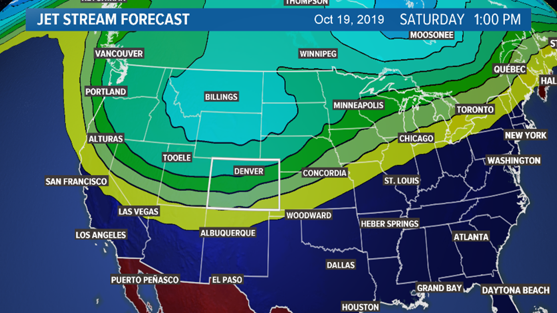
SATURDAY UPDATE:
October 19-21
Our next storm system is just entering the state at the time of this update. This is mainly a mountain storm, with a slight chance of snow pushing down onto the plains.
A Winter Weather Advisory is in place in the central and northern mountains for 4 to 10 inches of snow. The biggest surge of snow will be between midnight tonight and about 6am Sunday, but snow showers should continue a through the day and into Monday.
I-70 between Georgetown and Vail will probably be pretty messy in the morning.

Early morning about sunrise will probably be the metro areas best shot at seeing some flakes, although there may be a backdoor surge of air in the evening as well.
The RPM model shown here does have some snow and mixed showers pushing into part of the Denver metro between 5 and 7am. Looks like Manitou Springs has a shot at some snow as well. If these showers do materialize, it will likely yield less than an inch on the grass.
This storm may not completely leave the grasp of the state until Tuesday morning.
Chance of snow in Denver = 5%
October 23-24
Things are still looking good for an impactful snow storm next Wednesday. And the most interesting part of this one is that it looks to be more of an upslope storm affecting the foothills and the plains.
Both the GFS and the Euro have the storm moving in Wednesday evening or night, and lasting through the day Thursday. The Euro is a little less enthusiastic about the snow coverage but does have accumulation at DIA.
Because of the consistency over the past 24 hours of modeling I am comfortably doubling the chance of snow in Denver for this storm.
Chance of snow in Denver = 30%
October 27-30
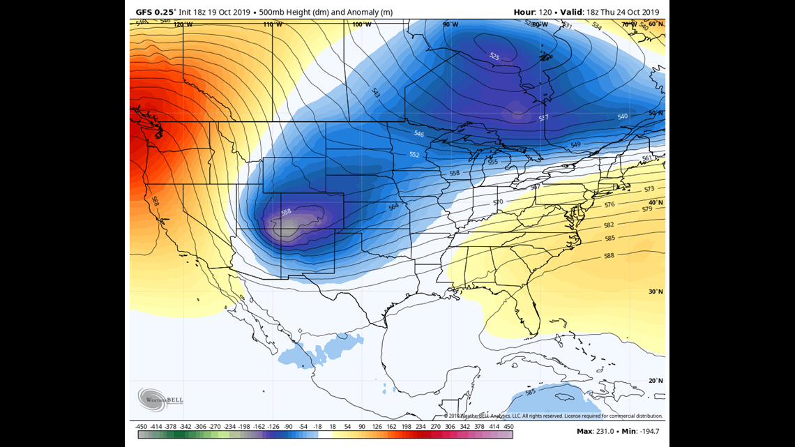
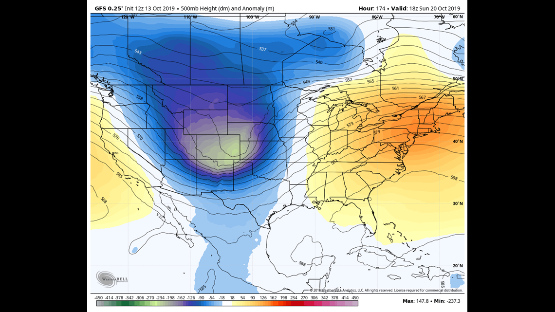
Due to recent consistency, I'm bringing back the last October storm system. There is still some wonky solutions going on though. The GFS shows a long lasting bend in the jet stream setting up in the middle of the country.
It is likely the models are picking up on something coming down the pipe, but maybe just doesn't know how to interpret it yet.
If the current solution does verify, it would mean an extended cold period with several chances at snow. A few days ago, the models were also hinting at a storm in this time-frame but it was shown as more of a traditional swipe from a passing low northeast of Colorado.
We better keep an eye on this one because it would not only mean more snow in Denver, but it would make Halloween night much colder with likely some snow on the ground at the time.
Chance of snow in Denver = 5%
FRIDAY UPDATE:
October 19-21
With no snow in Denver Friday, this blog feed continues. Next chance will be Sunday and Monday. There is a little better than a 1% chance with this storm but it's not much higher.
Expect it to enter the state late Saturday night. Models are showing a little different position and moisture content with recent solutions. Trending downward.
This storm could reach a little farther into the Front Range foothills, but will mainly be a mountain storm again.
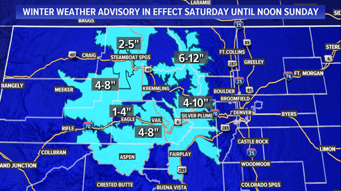
There is a Winter Weather Advisory out for 4 to 10 inches of snow in the central and northern mountains. It starts Saturday night at 9pm and goes to noon Sunday. The higher totals are for the passes and the lower are for the mountain towns. Steamboats forecast has come down to the 3-6 range. Winter Park, Leadville, and Vail are also in that range.
The best chance for snow down in the lower elevations will be Sunday morning. The Euro is the only model left that shows the possibility of getting enough flakes for accumulation. It shows a tenth of an inch in some spots, mostly the west metro.
Light snow will probably continue in the mountains all day Monday. Almost to the point the next system moves in.
Chance of snow in Denver = 5%
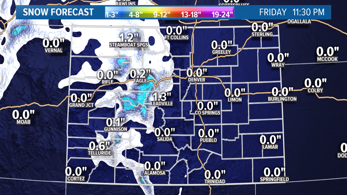
October 23-24
Both the GFS and the Euro have a storm system moving in on Wednesday. This may be our last chance to get snow in the metro during October. Models have been inconsistent with anything after next Thursday.
They are still showing a 1-3 inch storm in the metro overnight Wednesday into Thursday morning.
Chance of snow in Denver = 15%
Keeping an eye on Halloween. Still looks warm, dry, and windy. The GFS shows a daytime high temp of 61 degrees, with it in the low 50's for trick-or-treating.
THURSDAY UPDATE:
October 17-18
There is a cold front just starting to enter the state of Colorado this evening, and that will spread scattered rain and snow showers across the area. Mostly west of the Continental Divide.
The snow showers should reach Vail Pass by about 11pm or midnight. Not too much snow accumulation expected with this system. There may be 1-3 inches of snow on Vail Pass and the Eisenhower/Johnson Tunnels by 4pm Friday afternoon. Same with Berthoud and Rabbit Ears Passes.
There are no winter travel advisories expected.
Mostly dry downsloping winds on the Front Range, but as the front pushes across the area, there will likely be a brief amount of upslope winds to get some showers going on this side of the Divide.
They will likely be rain showers, and likely widely scattered as well. If you are lucky enough to catch one of these showers, there could be a wintry mix in them. I could see the Pikes Peak area getting some snow, or maybe the southern Jefferson and Douglas County foothills, but accumulation is unlikely.
Snow accumulation in Denver is almost zero.
Chance of snow in Denver = 1%
October 19-21
Could see some sunshine on Saturday between storms. The next one moves into the state on Saturday night.
This storm should be quite a bit more potent, with some very heavy snow expected in the northern mountains. The biggest part of the storm will be overnight Saturday into about noon on Sunday.
Steamboat Springs could get between 4 and 8 inches of snow.
Travel advisories are very possible in parts of the mountains, but mostly a rain and snow mix down in the lower elevations. The snow continues in the mountains through Monday night.
Both the GFS and the Euro show snow showers in the Denver area on Sunday, as well as the I-25 corridor from Castle Rock to Ft. Collins, and parts of the eastern plains. So a few of us are very likely to get enough for some accumulation. The Euro actually shows a tenth of an inch at DIA in the latest run.
The morning would be the best chance but the air will be borderline cold enough throughout the day on Sunday to bring a little snow. Just don't expect to be too impressed with it.
Since two models are showing snow in the metro, that should raise the chances. They do look widely scattered and borderline on temps tho, so we'll still have to get pretty lucky.
Chance of snow in Denver = 25%
October 23-24
Confidence is growing in a storm system next Wednesday and Thursday. As it is within that 7-day window now, it appears very likely to come our way. Good chance it will bring the mountains some more snow, but impacts at the lower elevations are still up in the air.
The GFS and the Euro have been consistent in showing a 1-3 inch snow for the metro though. This is developing into a stronger signal at least. That raises our chances just a bit.
The storm around Oct 28, still appears to be a miss for Colorado.
Chance of snow in Denver = 15%
The storm around Oct 28, still appears to be a miss for Colorado.
A storm may be in the area on Halloween as well, but the forecast is still for it to be windy and dry in the metro areas.
WEDNESDAY UPDATE:
October 17-18
Not too much has changed with the next storm. Rain and snow showers are expected to develop on the western slope after 6pm tomorrow (Thursday). The bulk of the heaviest mountain snow should be in the overnight hours, from midnight to 10am Friday.
Modeling shows an average of 2-4 inches of accumulation on the I-70 mountain passes, with higher amounts above 11,000 feet. Might be too low of an impact for a Winter Weather Advisory in the mountains, but wouldn't be shocked to see one.
The precipitation should remain mostly on the west side of the Continental Divide. The showers that do come over to the Front Range will likely be rain, or maybe a sleety mix. The NAM has some of those showers in the area of the Palmer Divide, but it doesn't look like much.
Snowflakes in the metro is unlikely, because the temps should be in the 50's when the precipitation comes. I'll leave a small chance in case some showers make it down to the metro in the early morning hours Friday. This impulse should completely exit the state to the east on Friday night.
Chance of snow in Denver = 1%
October 19-22
It won't be much of a break as the next surge of northern air arrives Saturday night. Snow should start back up in the northern mountains first, before midnight. This could be a extended period of snowfall for the mountains with chances of snow showers from Saturday night to Tuesday morning. The snow totals will likely not reflect that time length though.
Some areas could do pretty well and I would say there is a better chance of seeing some advisories or even warnings for this timeframe.
The high mountains passes could get up to 10 inches, with a little less down in the mountain towns. Looks like Steamboat Springs is in position to get the most with 4-6 inches.
As for the Front Range, there will be a couple opportunities to see snowflakes with this air. The first will be early Sunday morning. That will be a little more likely in the west metro than at DIA, but won't be much if it does happen.
Then another shot for snow after sunset on Sunday. That will include more area like the east metro, and even parts of the northeast plains. Could be a wintry mix of snow, sleet and graupel. Small hail with some convection can't be ruled out either. This will likely be less than 2 inches in isolated areas, while most spots get nothing.
With the jet stream overhead, some scattered showers will be possible on Monday as well.
I think I'll raise the chance for snow accumulation on Sunday just a bit under the guidance of the European model. If the NAM shows a goose egg when it gets in range, maybe then drop it back down.
Chance of snow in Denver = 20%
October 23-24
Models have been gaining confidence in a storm in the time-frame as well. It looks like this might be the metros best chance at snow accumulation. Looks like snow could start in the mountains on Wednesday Oct 23, and move down to the Front Range on Thursday Oct 24.
The last couple runs of the GFS and Euro have show a couple inches widespread in the metro.
It is within the 7-day forecast range, but it has not yet been consistent enough to raise the snow chances.
Chance of snow in Denver = 10%
October 28-29
Dropping this storm solution due to inconsistency in the last 4 runs. Halloween signal still looks dry.
TUESDAY UPDATE:
October 17-18
There are clearly two separate surges of cold air coming so I will address them as such. Starting with the system coming into the state from the west on Thursday. Modeling unanimously shows scattered rain and snow showers on the western slope starting Thursday night, probably after 6pm.
Snow should be able to continue overnight, into Friday evening. Both the GFS and the Euro show the I-70 mountain corridor getting mostly just 1-3 inches of accumulation, and a little more on the northern passes.
The GFS shows some showers spilling over onto the lower Front Range in the afternoon Friday, likely as light rain and scattered in nature. The Euro shows even less rain on the Front Range Friday.
The chance of snow accumulation in Denver will be very low. The lowest temp show by any model Friday night is only 40 degrees. It's not completely impossible so maybe just put in a small chance just because there is always a glimmer of hope when you have a cold front moving through the state.
Chance of snow in Denver = 2%
October 19-21
The next surge of polar air is cruising in right behind Friday's. Some snow showers could re-fire in the northern mountains by late Saturday night.
The snow will continue with few breaks in the mountains through the day on Sunday and even into Monday afternoon, but totals are not expected to be very high. Perhaps another 1-3 inches on the I-70 mountains corridor, with larger amounts in the higher elevations, and northern passes. The Park Range probably has the highest chance of getting more than 6 inches.

Winds out of the west usually means sinking and drying air on the Lee Side of the mountains on the Front Range. The GFS shows mostly dry conditions down low as a result. The Euro however, does show some showers on the Front Range, mostly early Sunday morning. Temperature will be close enough for those showers to be snow, but accumulation is unlikely.
With temps into the low 30's in Denver on Sunday morning, I would say there is a chance to see some snow flakes in the air, but accumulation, if it happens will be very low. All you need is a tenth of an inch tough, so I'll keep a chance in there.
Chance of snow in Denver = 10%
October 23-24
Models still consistently showing a storm nearby Colorado around Oct 23. They both show snow in the mountains and the Front Range with little to no accumulation. The timing on the GFS is more Thursday morning (Oct 24), and the Euro more on Wednesday night (Oct 23). Nothing alarming here yet but worth watching.
Chance of snow in Denver = 10%
October 28-29
Models have been very inconsistent on another storm around Oct 28. On some run completely dropping the solution. When they are in favor of a storm, they are also in favor of snow in the metro. So far Halloween looks dry and windy.
Chance of snow in Denver = 5%
SUNDAY UPDATE:
October 15
There is a weak trough moving towards Colorado, but will stay well to the north of the state. It will however drag a dry cold front across the Front Range overnight Monday into Tuesday morning. Tuesday will feel a little cooler as a result, but no precipitation is expected on the Front Range or on the mountain roads. Just a dusting on the high mountain peaks.
Chance of snow in Denver = 0%
October 18-20
The computer models are in disagreement on timing, location, and temperature, so I would say this remains a very weak signal. It is now only seven days out though, so there will likely be a trough with some impact during this time-frame, however the details are vague.
It really appears to be two separate surges of cold air.
The first storm looks to impact the mountains on Friday Oct 18. Models are not showing the cold front bringing much precipitation to the lower elevations. The GFS has some decent snow on the mountain passes, while the Euro does not show so much of an impact.
Then the more interesting storm hits on Saturday night and lasting through the day on Sunday. The models have been consistent on showing snow and rain on the Front Range with this one. It does not look as cold as our first storm with the GFS showing low temps in the 33-35 degree range. The Euro shows less impact with warmer temperatures, which could mean more of a rain and slush event. The Euro does however agree with some mountain impacts.
Because of the amazing performance by the GFS on the first storm, completely nailing the timing and intensity, I will raise the snow chances in Denver here just a bit, but with all the inconsistencies still remaining, it just won't go up much.
Chance of snow in Denver = 15%
More winter storms to follow
Nothing too consistent, but models continue to show a trend for more storm systems impacting the Denver area after next weekends.
One around Oct 25.
And another one around Oct 29.
FRIDAY UPDATE:
October 15
The next bend in the jet stream looks like it will be on Tuesday of next week (Oct 15). It should be weak and well to the north of Colorado. We will likely get a little surge of cold air, but little precip. The mountains could get a dusting but probably just on the higher northern peaks.
Chance of snow in Denver = 0%
October 18-20
There has been some consistency starting to show for a stronger system to move in around Oct 18. The GFS trough moving down that gets mixed into a tropical type system moving in off the east Pacific. That could boost the moisture content of a mainly arctic airmass.
It shows snow spreading into the Colorado mountains on Friday night (Oct 18), and then into the Denver area the afternoon of Oct 19.
This solution has held for 4 runs in a row now as a more significant storm than our first one. At least snow wise. It shows low temperatures in the 32-35 degree
The Euro has also been picking up on this storm system with similar characteristics.
Chance of snow in Denver = 10%
More winter storms
And the models are not done with October at that point. They are showing more winter storms coming before Halloween. One on Oct 24, and another around Oct 27-28. Not too much consistency though.
SUGGESTED VIDEOS | Science is Cool